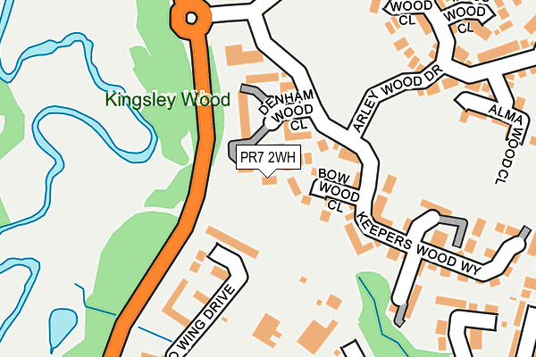
PR7 2WH lies on Denham Wood Close in Chorley. PR7 2WH is located in the Chorley South West electoral ward, within the local authority district of Chorley and the English Parliamentary constituency of Chorley. The Sub Integrated Care Board (ICB) Location is NHS Lancashire and South Cumbria ICB - 00X and the police force is Lancashire. This postcode has been in use since March 2005.


GetTheData
Source: OS OpenMap – Local (Ordnance Survey)
Source: OS VectorMap District (Ordnance Survey)
Licence: Open Government Licence (requires attribution)
| Easting | 356932 |
| Northing | 416595 |
| Latitude | 53.644097 |
| Longitude | -2.652942 |
GetTheData
Source: Open Postcode Geo
Licence: Open Government Licence
| Street | Denham Wood Close |
| Town/City | Chorley |
| Country | England |
| Postcode District | PR7 |
➜ See where PR7 is on a map ➜ Where is Chorley? | |
GetTheData
Source: Land Registry Price Paid Data
Licence: Open Government Licence
Elevation or altitude of PR7 2WH as distance above sea level:
| Metres | Feet | |
|---|---|---|
| Elevation | 50m | 164ft |
Elevation is measured from the approximate centre of the postcode, to the nearest point on an OS contour line from OS Terrain 50, which has contour spacing of ten vertical metres.
➜ How high above sea level am I? Find the elevation of your current position using your device's GPS.
GetTheData
Source: Open Postcode Elevation
Licence: Open Government Licence
| Ward | Chorley South West |
| Constituency | Chorley |
GetTheData
Source: ONS Postcode Database
Licence: Open Government Licence
| Keepers Wood Drive | Gillibrand | 105m |
| Nightingale Way (Yarrow Valley Way) | Gillibrand | 228m |
| Burghwood Way (Gillibrand Link Road) | Gillibrand | 237m |
| Arley Wood Drive | Gillibrand | 283m |
| Burgh Wood Way | Gillibrand | 295m |
| Chorley Station | 2km |
| Euxton Balshaw Lane Station | 2.2km |
| Buckshaw Parkway Station | 3.3km |
GetTheData
Source: NaPTAN
Licence: Open Government Licence
| Percentage of properties with Next Generation Access | 100.0% |
| Percentage of properties with Superfast Broadband | 100.0% |
| Percentage of properties with Ultrafast Broadband | 0.0% |
| Percentage of properties with Full Fibre Broadband | 0.0% |
Superfast Broadband is between 30Mbps and 300Mbps
Ultrafast Broadband is > 300Mbps
| Percentage of properties unable to receive 2Mbps | 0.0% |
| Percentage of properties unable to receive 5Mbps | 0.0% |
| Percentage of properties unable to receive 10Mbps | 0.0% |
| Percentage of properties unable to receive 30Mbps | 0.0% |
GetTheData
Source: Ofcom
Licence: Ofcom Terms of Use (requires attribution)
GetTheData
Source: ONS Postcode Database
Licence: Open Government Licence


➜ Get more ratings from the Food Standards Agency
GetTheData
Source: Food Standards Agency
Licence: FSA terms & conditions
| Last Collection | |||
|---|---|---|---|
| Location | Mon-Fri | Sat | Distance |
| Common Bank Industrial Estate | 17:45 | 1,151m | |
| Common Bank Industrial Estate | 17:45 | 11:30 | 1,155m |
| Hornchurch Drive | 17:30 | 11:30 | 1,233m |
GetTheData
Source: Dracos
Licence: Creative Commons Attribution-ShareAlike
The below table lists the International Territorial Level (ITL) codes (formerly Nomenclature of Territorial Units for Statistics (NUTS) codes) and Local Administrative Units (LAU) codes for PR7 2WH:
| ITL 1 Code | Name |
|---|---|
| TLD | North West (England) |
| ITL 2 Code | Name |
| TLD4 | Lancashire |
| ITL 3 Code | Name |
| TLD47 | Chorley and West Lancashire |
| LAU 1 Code | Name |
| E07000118 | Chorley |
GetTheData
Source: ONS Postcode Directory
Licence: Open Government Licence
The below table lists the Census Output Area (OA), Lower Layer Super Output Area (LSOA), and Middle Layer Super Output Area (MSOA) for PR7 2WH:
| Code | Name | |
|---|---|---|
| OA | E00170497 | |
| LSOA | E01024945 | Chorley 012D |
| MSOA | E02005200 | Chorley 012 |
GetTheData
Source: ONS Postcode Directory
Licence: Open Government Licence
| PR7 2WG | Denham Wood Close | 27m |
| PR7 2WF | Denham Wood Close | 30m |
| PR7 2WE | Denham Wood Close | 33m |
| PR7 2WJ | Hunters Wood Court | 49m |
| PR7 2WL | Hunters Wood Court | 52m |
| PR7 2WD | Denham Wood Close | 76m |
| PR7 2WA | Denham Wood Close | 103m |
| PR7 2WB | Denham Wood Close | 114m |
| PR7 2RH | Redwing Drive | 120m |
| PR7 2FU | Keepers Wood Way | 161m |
GetTheData
Source: Open Postcode Geo; Land Registry Price Paid Data
Licence: Open Government Licence