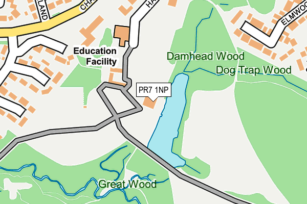
PR7 1NP is located in the Chorley North West electoral ward, within the local authority district of Chorley and the English Parliamentary constituency of Chorley. The Sub Integrated Care Board (ICB) Location is NHS Lancashire and South Cumbria ICB - 00X and the police force is Lancashire. This postcode has been in use since January 1980.


GetTheData
Source: OS OpenMap – Local (Ordnance Survey)
Source: OS VectorMap District (Ordnance Survey)
Licence: Open Government Licence (requires attribution)
| Easting | 357455 |
| Northing | 418297 |
| Latitude | 53.659437 |
| Longitude | -2.645265 |
GetTheData
Source: Open Postcode Geo
Licence: Open Government Licence
| Country | England |
| Postcode District | PR7 |
➜ See where PR7 is on a map ➜ Where is Chorley? | |
GetTheData
Source: Land Registry Price Paid Data
Licence: Open Government Licence
Elevation or altitude of PR7 1NP as distance above sea level:
| Metres | Feet | |
|---|---|---|
| Elevation | 60m | 197ft |
Elevation is measured from the approximate centre of the postcode, to the nearest point on an OS contour line from OS Terrain 50, which has contour spacing of ten vertical metres.
➜ How high above sea level am I? Find the elevation of your current position using your device's GPS.
GetTheData
Source: Open Postcode Elevation
Licence: Open Government Licence
| Ward | Chorley North West |
| Constituency | Chorley |
GetTheData
Source: ONS Postcode Database
Licence: Open Government Licence
| Village Centre (Chancery Road) | Astley Village | 229m |
| Buckshaw Cps (Chancery Road) | Astley Village | 264m |
| Chancery Road North (Chancery Road) | Astley Village | 372m |
| Chancery Road | Astley Village | 377m |
| Deer Fold (Chancery Road) | Astley Village | 418m |
| Chorley Station | 1.4km |
| Euxton Balshaw Lane Station | 1.8km |
| Buckshaw Parkway Station | 1.9km |
GetTheData
Source: NaPTAN
Licence: Open Government Licence
GetTheData
Source: ONS Postcode Database
Licence: Open Government Licence


➜ Get more ratings from the Food Standards Agency
GetTheData
Source: Food Standards Agency
Licence: FSA terms & conditions
| Last Collection | |||
|---|---|---|---|
| Location | Mon-Fri | Sat | Distance |
| Astley Village Post Office | 17:00 | 11:30 | 226m |
| 88 Hamilton Road | 17:15 | 11:30 | 644m |
| Common Bank Industrial Estate | 17:45 | 812m | |
GetTheData
Source: Dracos
Licence: Creative Commons Attribution-ShareAlike
The below table lists the International Territorial Level (ITL) codes (formerly Nomenclature of Territorial Units for Statistics (NUTS) codes) and Local Administrative Units (LAU) codes for PR7 1NP:
| ITL 1 Code | Name |
|---|---|
| TLD | North West (England) |
| ITL 2 Code | Name |
| TLD4 | Lancashire |
| ITL 3 Code | Name |
| TLD47 | Chorley and West Lancashire |
| LAU 1 Code | Name |
| E07000118 | Chorley |
GetTheData
Source: ONS Postcode Directory
Licence: Open Government Licence
The below table lists the Census Output Area (OA), Lower Layer Super Output Area (LSOA), and Middle Layer Super Output Area (MSOA) for PR7 1NP:
| Code | Name | |
|---|---|---|
| OA | E00126578 | |
| LSOA | E01024934 | Chorley 008C |
| MSOA | E02005196 | Chorley 008 |
GetTheData
Source: ONS Postcode Directory
Licence: Open Government Licence
| PR7 1UP | Merefield | 250m |
| PR7 1UX | Elmwood | 302m |
| PR7 1UU | Elmwood | 311m |
| PR7 1RU | Millwood Glade | 323m |
| PR7 1UR | Merefield | 342m |
| PR7 1XJ | Judeland | 366m |
| PR7 1NA | Hampton Close | 379m |
| PR7 1TY | Browns Hey | 402m |
| PR7 1XX | Woodmancote | 422m |
| PR7 1LZ | Chatsworth Close | 426m |
GetTheData
Source: Open Postcode Geo; Land Registry Price Paid Data
Licence: Open Government Licence