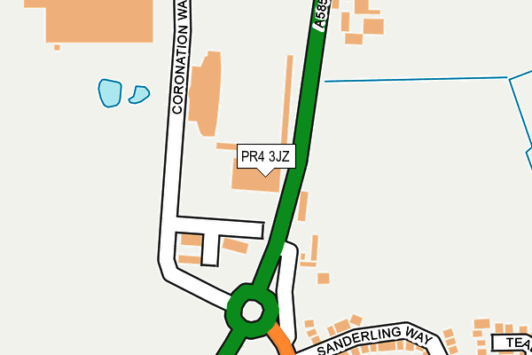
PR4 3JZ is located in the Medlar-with-Wesham electoral ward, within the local authority district of Fylde and the English Parliamentary constituency of Fylde. The Sub Integrated Care Board (ICB) Location is NHS Lancashire and South Cumbria ICB - 02M and the police force is Lancashire. This postcode has been in use since June 2016.


GetTheData
Source: OS OpenMap – Local (Ordnance Survey)
Source: OS VectorMap District (Ordnance Survey)
Licence: Open Government Licence (requires attribution)
| Easting | 341525 |
| Northing | 433727 |
| Latitude | 53.796563 |
| Longitude | -2.889212 |
GetTheData
Source: Open Postcode Geo
Licence: Open Government Licence
| Country | England |
| Postcode District | PR4 |
➜ See where PR4 is on a map ➜ Where is Wesham? | |
GetTheData
Source: Land Registry Price Paid Data
Licence: Open Government Licence
Elevation or altitude of PR4 3JZ as distance above sea level:
| Metres | Feet | |
|---|---|---|
| Elevation | 20m | 66ft |
Elevation is measured from the approximate centre of the postcode, to the nearest point on an OS contour line from OS Terrain 50, which has contour spacing of ten vertical metres.
➜ How high above sea level am I? Find the elevation of your current position using your device's GPS.
GetTheData
Source: Open Postcode Elevation
Licence: Open Government Licence
| Ward | Medlar-with-wesham |
| Constituency | Fylde |
GetTheData
Source: ONS Postcode Database
Licence: Open Government Licence
| Afc Fylde (Fleetwood Road) | Wesham | 33m |
| Afc Fylde (Fleetwood Road) | Wesham | 42m |
| Wesham Recreation Ground (Garstang Road North) | Wesham | 307m |
| St Josephs Rcps (Fleetwood Road) | Wesham | 404m |
| St. Josephs Church (Garstang Road North) | Wesham | 520m |
| Kirkham & Wesham Station | 1.1km |
| Moss Side Station | 5km |
| Salwick Station | 5km |
GetTheData
Source: NaPTAN
Licence: Open Government Licence
GetTheData
Source: ONS Postcode Database
Licence: Open Government Licence


➜ Get more ratings from the Food Standards Agency
GetTheData
Source: Food Standards Agency
Licence: FSA terms & conditions
| Last Collection | |||
|---|---|---|---|
| Location | Mon-Fri | Sat | Distance |
| Wesham Cross | 17:00 | 09:45 | 452m |
| Wesham Post Office | 17:00 | 09:45 | 819m |
| Sunnybank | 17:30 | 09:45 | 1,467m |
GetTheData
Source: Dracos
Licence: Creative Commons Attribution-ShareAlike
The below table lists the International Territorial Level (ITL) codes (formerly Nomenclature of Territorial Units for Statistics (NUTS) codes) and Local Administrative Units (LAU) codes for PR4 3JZ:
| ITL 1 Code | Name |
|---|---|
| TLD | North West (England) |
| ITL 2 Code | Name |
| TLD4 | Lancashire |
| ITL 3 Code | Name |
| TLD45 | Mid Lancashire |
| LAU 1 Code | Name |
| E07000119 | Fylde |
GetTheData
Source: ONS Postcode Directory
Licence: Open Government Licence
The below table lists the Census Output Area (OA), Lower Layer Super Output Area (LSOA), and Middle Layer Super Output Area (MSOA) for PR4 3JZ:
| Code | Name | |
|---|---|---|
| OA | E00126952 | |
| LSOA | E01025012 | Fylde 002E |
| MSOA | E02005204 | Fylde 002 |
GetTheData
Source: ONS Postcode Directory
Licence: Open Government Licence
| PR4 3HD | Fleetwood Road | 227m |
| PR4 3EP | Fairfield Way | 281m |
| PR4 3JL | Sanderling Way | 347m |
| PR4 3EN | Forest Gate | 350m |
| PR4 3JT | Teal Close | 351m |
| PR4 3EG | Woodland View | 399m |
| PR4 3BX | Queens Place | 409m |
| PR4 3BY | Fleetwood Road | 421m |
| PR4 3DW | Green Bank | 424m |
| PR4 3DY | Douglas Avenue | 426m |
GetTheData
Source: Open Postcode Geo; Land Registry Price Paid Data
Licence: Open Government Licence