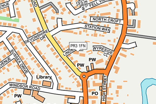
PR3 1FN lies on Linden Grove in Garstang, Preston. PR3 1FN is located in the Garstang electoral ward, within the local authority district of Wyre and the English Parliamentary constituency of Wyre and Preston North. The Sub Integrated Care Board (ICB) Location is NHS Lancashire and South Cumbria ICB - 02M and the police force is Lancashire. This postcode has been in use since January 1980.


GetTheData
Source: OS OpenMap – Local (Ordnance Survey)
Source: OS VectorMap District (Ordnance Survey)
Licence: Open Government Licence (requires attribution)
| Easting | 349145 |
| Northing | 445519 |
| Latitude | 53.903325 |
| Longitude | -2.775503 |
GetTheData
Source: Open Postcode Geo
Licence: Open Government Licence
| Street | Linden Grove |
| Locality | Garstang |
| Town/City | Preston |
| Country | England |
| Postcode District | PR3 |
➜ See where PR3 is on a map ➜ Where is Garstang? | |
GetTheData
Source: Land Registry Price Paid Data
Licence: Open Government Licence
Elevation or altitude of PR3 1FN as distance above sea level:
| Metres | Feet | |
|---|---|---|
| Elevation | 20m | 66ft |
Elevation is measured from the approximate centre of the postcode, to the nearest point on an OS contour line from OS Terrain 50, which has contour spacing of ten vertical metres.
➜ How high above sea level am I? Find the elevation of your current position using your device's GPS.
GetTheData
Source: Open Postcode Elevation
Licence: Open Government Licence
| Ward | Garstang |
| Constituency | Wyre And Preston North |
GetTheData
Source: ONS Postcode Database
Licence: Open Government Licence
1, LINDEN GROVE, GARSTANG, PRESTON, PR3 1FN 2009 1 JUL £242,500 |
2, LINDEN GROVE, GARSTANG, PRESTON, PR3 1FN 1996 30 DEC £58,000 |
GetTheData
Source: HM Land Registry Price Paid Data
Licence: Contains HM Land Registry data © Crown copyright and database right 2025. This data is licensed under the Open Government Licence v3.0.
| Council Offices (High Street) | Garstang | 126m |
| Council Offices (High Street) | Garstang | 140m |
| Post Office (High Street) | Garstang | 171m |
| Windsor Road | Garstang | 182m |
| Park Hill Road | Garstang | 192m |
GetTheData
Source: NaPTAN
Licence: Open Government Licence
| Percentage of properties with Next Generation Access | 100.0% |
| Percentage of properties with Superfast Broadband | 100.0% |
| Percentage of properties with Ultrafast Broadband | 0.0% |
| Percentage of properties with Full Fibre Broadband | 0.0% |
Superfast Broadband is between 30Mbps and 300Mbps
Ultrafast Broadband is > 300Mbps
| Median download speed | 21.7Mbps |
| Average download speed | 34.6Mbps |
| Maximum download speed | 65.42Mbps |
| Median upload speed | 1.2Mbps |
| Average upload speed | 7.0Mbps |
| Maximum upload speed | 19.88Mbps |
| Percentage of properties unable to receive 2Mbps | 0.0% |
| Percentage of properties unable to receive 5Mbps | 0.0% |
| Percentage of properties unable to receive 10Mbps | 0.0% |
| Percentage of properties unable to receive 30Mbps | 0.0% |
GetTheData
Source: Ofcom
Licence: Ofcom Terms of Use (requires attribution)
Estimated total energy consumption in PR3 1FN by fuel type, 2015.
| Consumption (kWh) | 166,046 |
|---|---|
| Meter count | 9 |
| Mean (kWh/meter) | 18,450 |
| Median (kWh/meter) | 18,652 |
| Consumption (kWh) | 36,709 |
|---|---|
| Meter count | 8 |
| Mean (kWh/meter) | 4,589 |
| Median (kWh/meter) | 4,642 |
GetTheData
Source: Postcode level gas estimates: 2015 (experimental)
Source: Postcode level electricity estimates: 2015 (experimental)
Licence: Open Government Licence
GetTheData
Source: ONS Postcode Database
Licence: Open Government Licence


➜ Get more ratings from the Food Standards Agency
GetTheData
Source: Food Standards Agency
Licence: FSA terms & conditions
| Last Collection | |||
|---|---|---|---|
| Location | Mon-Fri | Sat | Distance |
| Garstang Post Office | 17:30 | 11:45 | 290m |
| Croston Road | 17:15 | 11:15 | 305m |
| High Street | 17:30 | 11:45 | 318m |
GetTheData
Source: Dracos
Licence: Creative Commons Attribution-ShareAlike
The below table lists the International Territorial Level (ITL) codes (formerly Nomenclature of Territorial Units for Statistics (NUTS) codes) and Local Administrative Units (LAU) codes for PR3 1FN:
| ITL 1 Code | Name |
|---|---|
| TLD | North West (England) |
| ITL 2 Code | Name |
| TLD4 | Lancashire |
| ITL 3 Code | Name |
| TLD44 | Lancaster and Wyre |
| LAU 1 Code | Name |
| E07000128 | Wyre |
GetTheData
Source: ONS Postcode Directory
Licence: Open Government Licence
The below table lists the Census Output Area (OA), Lower Layer Super Output Area (LSOA), and Middle Layer Super Output Area (MSOA) for PR3 1FN:
| Code | Name | |
|---|---|---|
| OA | E00129697 | |
| LSOA | E01025558 | Wyre 007C |
| MSOA | E02005325 | Wyre 007 |
GetTheData
Source: ONS Postcode Directory
Licence: Open Government Licence
| PR3 1EN | Croston Road | 80m |
| PR3 1FB | Wyreside Close | 80m |
| PR3 1DN | Station Way | 82m |
| PR3 1FL | Croston Road | 102m |
| PR3 1EZ | Park Hill Court | 127m |
| PR3 1FE | Dorchester Road | 144m |
| PR3 1EX | Windsor Road | 145m |
| PR3 1EB | High Street | 155m |
| PR3 1DL | Smithy Close | 165m |
| PR3 1HG | North Croft | 170m |
GetTheData
Source: Open Postcode Geo; Land Registry Price Paid Data
Licence: Open Government Licence