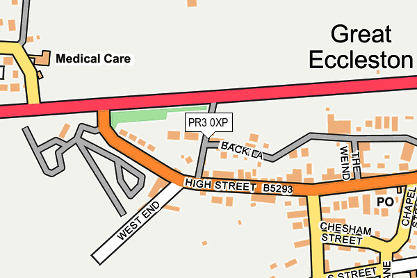
PR3 0XP lies on Butts Lane in Great Eccleston, Preston. PR3 0XP is located in the Great Eccleston electoral ward, within the local authority district of Wyre and the English Parliamentary constituency of Wyre and Preston North. The Sub Integrated Care Board (ICB) Location is NHS Lancashire and South Cumbria ICB - 02M and the police force is Lancashire. This postcode has been in use since January 1980.


GetTheData
Source: OS OpenMap – Local (Ordnance Survey)
Source: OS VectorMap District (Ordnance Survey)
Licence: Open Government Licence (requires attribution)
| Easting | 342526 |
| Northing | 440259 |
| Latitude | 53.855376 |
| Longitude | -2.875240 |
GetTheData
Source: Open Postcode Geo
Licence: Open Government Licence
| Street | Butts Lane |
| Locality | Great Eccleston |
| Town/City | Preston |
| Country | England |
| Postcode District | PR3 |
➜ See where PR3 is on a map ➜ Where is Great Eccleston? | |
GetTheData
Source: Land Registry Price Paid Data
Licence: Open Government Licence
Elevation or altitude of PR3 0XP as distance above sea level:
| Metres | Feet | |
|---|---|---|
| Elevation | 10m | 33ft |
Elevation is measured from the approximate centre of the postcode, to the nearest point on an OS contour line from OS Terrain 50, which has contour spacing of ten vertical metres.
➜ How high above sea level am I? Find the elevation of your current position using your device's GPS.
GetTheData
Source: Open Postcode Elevation
Licence: Open Government Licence
| Ward | Great Eccleston |
| Constituency | Wyre And Preston North |
GetTheData
Source: ONS Postcode Database
Licence: Open Government Licence
THORNFIELD, BUTTS LANE, GREAT ECCLESTON, PRESTON, PR3 0XP 2023 15 SEP £415,000 |
HAWTHORN COTTAGE, BUTTS LANE, GREAT ECCLESTON, PRESTON, PR3 0XP 2019 11 OCT £141,000 |
➜ Great Eccleston house prices
GetTheData
Source: HM Land Registry Price Paid Data
Licence: Contains HM Land Registry data © Crown copyright and database right 2025. This data is licensed under the Open Government Licence v3.0.
| Square (High Street) | Great Eccleston | 138m |
| White Bull (Back Lane) | Great Eccleston | 183m |
| Square (The Square) | Great Eccleston | 198m |
| Chesham Lodge (Copp Lane) | Great Eccleston | 249m |
| Chesham Lodge (Copp Lane) | Great Eccleston | 260m |
GetTheData
Source: NaPTAN
Licence: Open Government Licence
| Percentage of properties with Next Generation Access | 100.0% |
| Percentage of properties with Superfast Broadband | 100.0% |
| Percentage of properties with Ultrafast Broadband | 0.0% |
| Percentage of properties with Full Fibre Broadband | 0.0% |
Superfast Broadband is between 30Mbps and 300Mbps
Ultrafast Broadband is > 300Mbps
| Percentage of properties unable to receive 2Mbps | 0.0% |
| Percentage of properties unable to receive 5Mbps | 0.0% |
| Percentage of properties unable to receive 10Mbps | 0.0% |
| Percentage of properties unable to receive 30Mbps | 0.0% |
GetTheData
Source: Ofcom
Licence: Ofcom Terms of Use (requires attribution)
Estimated total energy consumption in PR3 0XP by fuel type, 2015.
| Consumption (kWh) | 65,157 |
|---|---|
| Meter count | 6 |
| Mean (kWh/meter) | 10,859 |
| Median (kWh/meter) | 10,344 |
GetTheData
Source: Postcode level gas estimates: 2015 (experimental)
Source: Postcode level electricity estimates: 2015 (experimental)
Licence: Open Government Licence
GetTheData
Source: ONS Postcode Database
Licence: Open Government Licence


➜ Get more ratings from the Food Standards Agency
GetTheData
Source: Food Standards Agency
Licence: FSA terms & conditions
| Last Collection | |||
|---|---|---|---|
| Location | Mon-Fri | Sat | Distance |
| Great Singleton | 17:30 | 12:00 | 4,906m |
GetTheData
Source: Dracos
Licence: Creative Commons Attribution-ShareAlike
The below table lists the International Territorial Level (ITL) codes (formerly Nomenclature of Territorial Units for Statistics (NUTS) codes) and Local Administrative Units (LAU) codes for PR3 0XP:
| ITL 1 Code | Name |
|---|---|
| TLD | North West (England) |
| ITL 2 Code | Name |
| TLD4 | Lancashire |
| ITL 3 Code | Name |
| TLD44 | Lancaster and Wyre |
| LAU 1 Code | Name |
| E07000128 | Wyre |
GetTheData
Source: ONS Postcode Directory
Licence: Open Government Licence
The below table lists the Census Output Area (OA), Lower Layer Super Output Area (LSOA), and Middle Layer Super Output Area (MSOA) for PR3 0XP:
| Code | Name | |
|---|---|---|
| OA | E00129711 | |
| LSOA | E01025562 | Wyre 009B |
| MSOA | E02005327 | Wyre 009 |
GetTheData
Source: ONS Postcode Directory
Licence: Open Government Licence
| PR3 0YL | West End | 52m |
| PR3 0ZL | West End | 89m |
| PR3 0XJ | Back Lane | 189m |
| PR3 0ZD | Leckonby Street | 206m |
| PR3 0ZB | The Square | 216m |
| PR3 0YD | Chesham Street | 253m |
| PR3 0ZG | Chesham Lodge | 268m |
| PR3 0YB | High Street | 282m |
| PR3 0YE | Halsall Square | 294m |
| PR3 0YH | South Street | 300m |
GetTheData
Source: Open Postcode Geo; Land Registry Price Paid Data
Licence: Open Government Licence