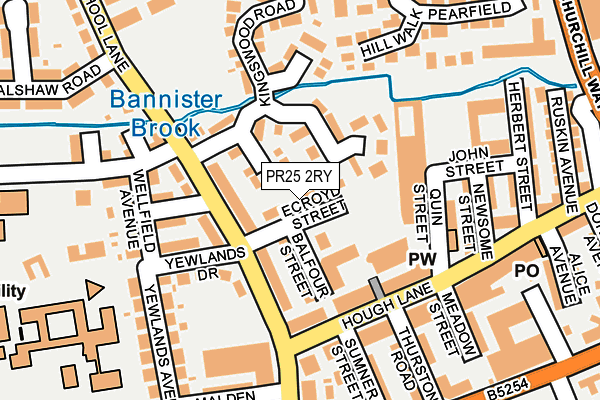
PR25 2RY lies on Ecroyd Street in Leyland. PR25 2RY is located in the Leyland Central electoral ward, within the local authority district of South Ribble and the English Parliamentary constituency of South Ribble. The Sub Integrated Care Board (ICB) Location is NHS Lancashire and South Cumbria ICB - 00X and the police force is Lancashire. This postcode has been in use since June 2001.


GetTheData
Source: OS OpenMap – Local (Ordnance Survey)
Source: OS VectorMap District (Ordnance Survey)
Licence: Open Government Licence (requires attribution)
| Easting | 354146 |
| Northing | 422388 |
| Latitude | 53.695908 |
| Longitude | -2.695942 |
GetTheData
Source: Open Postcode Geo
Licence: Open Government Licence
| Street | Ecroyd Street |
| Town/City | Leyland |
| Country | England |
| Postcode District | PR25 |
➜ See where PR25 is on a map ➜ Where is Leyland? | |
GetTheData
Source: Land Registry Price Paid Data
Licence: Open Government Licence
Elevation or altitude of PR25 2RY as distance above sea level:
| Metres | Feet | |
|---|---|---|
| Elevation | 30m | 98ft |
Elevation is measured from the approximate centre of the postcode, to the nearest point on an OS contour line from OS Terrain 50, which has contour spacing of ten vertical metres.
➜ How high above sea level am I? Find the elevation of your current position using your device's GPS.
GetTheData
Source: Open Postcode Elevation
Licence: Open Government Licence
| Ward | Leyland Central |
| Constituency | South Ribble |
GetTheData
Source: ONS Postcode Database
Licence: Open Government Licence
| Yewlands Drive (School Lane) | Leyland Town Centre | 102m |
| Gables Hotel (Hough Lane) | Leyland Town Centre | 124m |
| Gables Hotel (Hough Lane) | Leyland Town Centre | 137m |
| Royal British Legion (School Lane) | Leyland Town Centre | 166m |
| King Street (Towngate) | Leyland Town Centre | 213m |
| Leyland Station | 0.7km |
| Lostock Hall Station | 3.2km |
| Buckshaw Parkway Station | 3.4km |
GetTheData
Source: NaPTAN
Licence: Open Government Licence
| Percentage of properties with Next Generation Access | 100.0% |
| Percentage of properties with Superfast Broadband | 100.0% |
| Percentage of properties with Ultrafast Broadband | 100.0% |
| Percentage of properties with Full Fibre Broadband | 0.0% |
Superfast Broadband is between 30Mbps and 300Mbps
Ultrafast Broadband is > 300Mbps
| Percentage of properties unable to receive 2Mbps | 0.0% |
| Percentage of properties unable to receive 5Mbps | 0.0% |
| Percentage of properties unable to receive 10Mbps | 0.0% |
| Percentage of properties unable to receive 30Mbps | 0.0% |
GetTheData
Source: Ofcom
Licence: Ofcom Terms of Use (requires attribution)
GetTheData
Source: ONS Postcode Database
Licence: Open Government Licence


➜ Get more ratings from the Food Standards Agency
GetTheData
Source: Food Standards Agency
Licence: FSA terms & conditions
| Last Collection | |||
|---|---|---|---|
| Location | Mon-Fri | Sat | Distance |
| Hough Lane (Kwik Save) | 17:30 | 12:30 | 150m |
| Leyland Post Office | 18:00 | 12:30 | 172m |
| Leyland Post Office | 18:00 | 12:30 | 173m |
GetTheData
Source: Dracos
Licence: Creative Commons Attribution-ShareAlike
The below table lists the International Territorial Level (ITL) codes (formerly Nomenclature of Territorial Units for Statistics (NUTS) codes) and Local Administrative Units (LAU) codes for PR25 2RY:
| ITL 1 Code | Name |
|---|---|
| TLD | North West (England) |
| ITL 2 Code | Name |
| TLD4 | Lancashire |
| ITL 3 Code | Name |
| TLD45 | Mid Lancashire |
| LAU 1 Code | Name |
| E07000126 | South Ribble |
GetTheData
Source: ONS Postcode Directory
Licence: Open Government Licence
The below table lists the Census Output Area (OA), Lower Layer Super Output Area (LSOA), and Middle Layer Super Output Area (MSOA) for PR25 2RY:
| Code | Name | |
|---|---|---|
| OA | E00129020 | |
| LSOA | E01025422 | South Ribble 013B |
| MSOA | E02005299 | South Ribble 013 |
GetTheData
Source: ONS Postcode Directory
Licence: Open Government Licence
| PR25 2UN | Kingswood Road | 52m |
| PR25 2TD | Balfour Street | 67m |
| PR25 2TT | School Lane | 73m |
| PR25 2TS | School Lane | 82m |
| PR25 2SB | Hough Lane | 110m |
| PR25 2TR | Chatsworth Road | 138m |
| PR25 2TN | Yewlands Drive | 142m |
| PR25 2SD | Hough Lane | 154m |
| PR25 2SY | Newsome Street | 167m |
| PR25 2TQ | Wellfield Avenue | 171m |
GetTheData
Source: Open Postcode Geo; Land Registry Price Paid Data
Licence: Open Government Licence