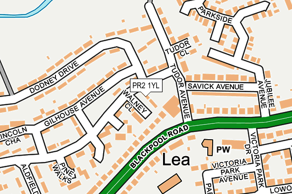
PR2 1YL lies on Hardwen Avenue in Lea, Preston. PR2 1YL is located in the Lea & Larches electoral ward, within the local authority district of Preston and the English Parliamentary constituency of Fylde. The Sub Integrated Care Board (ICB) Location is NHS Lancashire and South Cumbria ICB - 01E and the police force is Lancashire. This postcode has been in use since January 1980.


GetTheData
Source: OS OpenMap – Local (Ordnance Survey)
Source: OS VectorMap District (Ordnance Survey)
Licence: Open Government Licence (requires attribution)
| Easting | 349453 |
| Northing | 430379 |
| Latitude | 53.767291 |
| Longitude | -2.768320 |
GetTheData
Source: Open Postcode Geo
Licence: Open Government Licence
| Street | Hardwen Avenue |
| Locality | Lea |
| Town/City | Preston |
| Country | England |
| Postcode District | PR2 |
➜ See where PR2 is on a map ➜ Where is Preston? | |
GetTheData
Source: Land Registry Price Paid Data
Licence: Open Government Licence
Elevation or altitude of PR2 1YL as distance above sea level:
| Metres | Feet | |
|---|---|---|
| Elevation | 10m | 33ft |
Elevation is measured from the approximate centre of the postcode, to the nearest point on an OS contour line from OS Terrain 50, which has contour spacing of ten vertical metres.
➜ How high above sea level am I? Find the elevation of your current position using your device's GPS.
GetTheData
Source: Open Postcode Elevation
Licence: Open Government Licence
| Ward | Lea & Larches |
| Constituency | Fylde |
GetTheData
Source: ONS Postcode Database
Licence: Open Government Licence
| Tudor Ave (Blackpool Road) | Lea | 78m |
| Tudor Avenue | Lea | 79m |
| Greenside Avenue (Dodney Drive) | Lea | 113m |
| The Pig & Whistle (Blackpool Road) | Lea | 199m |
| The Pig & Whistle (Blackpool Road) | Lea | 205m |
| Salwick Station | 3.6km |
| Preston Station | 4.1km |
GetTheData
Source: NaPTAN
Licence: Open Government Licence
| Percentage of properties with Next Generation Access | 100.0% |
| Percentage of properties with Superfast Broadband | 100.0% |
| Percentage of properties with Ultrafast Broadband | 100.0% |
| Percentage of properties with Full Fibre Broadband | 0.0% |
Superfast Broadband is between 30Mbps and 300Mbps
Ultrafast Broadband is > 300Mbps
| Percentage of properties unable to receive 2Mbps | 0.0% |
| Percentage of properties unable to receive 5Mbps | 0.0% |
| Percentage of properties unable to receive 10Mbps | 0.0% |
| Percentage of properties unable to receive 30Mbps | 0.0% |
GetTheData
Source: Ofcom
Licence: Ofcom Terms of Use (requires attribution)
GetTheData
Source: ONS Postcode Database
Licence: Open Government Licence


➜ Get more ratings from the Food Standards Agency
GetTheData
Source: Food Standards Agency
Licence: FSA terms & conditions
| Last Collection | |||
|---|---|---|---|
| Location | Mon-Fri | Sat | Distance |
| Lea School | 16:00 | 08:00 | 1,632m |
| Navigation Way, Ashton | 17:30 | 11:30 | 1,742m |
| Victoria Mansions | 17:00 | 11:00 | 1,942m |
GetTheData
Source: Dracos
Licence: Creative Commons Attribution-ShareAlike
The below table lists the International Territorial Level (ITL) codes (formerly Nomenclature of Territorial Units for Statistics (NUTS) codes) and Local Administrative Units (LAU) codes for PR2 1YL:
| ITL 1 Code | Name |
|---|---|
| TLD | North West (England) |
| ITL 2 Code | Name |
| TLD4 | Lancashire |
| ITL 3 Code | Name |
| TLD45 | Mid Lancashire |
| LAU 1 Code | Name |
| E07000123 | Preston |
GetTheData
Source: ONS Postcode Directory
Licence: Open Government Licence
The below table lists the Census Output Area (OA), Lower Layer Super Output Area (LSOA), and Middle Layer Super Output Area (MSOA) for PR2 1YL:
| Code | Name | |
|---|---|---|
| OA | E00128265 | |
| LSOA | E01025270 | Preston 010A |
| MSOA | E02005262 | Preston 010 |
GetTheData
Source: ONS Postcode Directory
Licence: Open Government Licence
| PR2 1WL | Walney Close | 42m |
| PR2 1YN | Greenside Avenue | 71m |
| PR2 1WD | Rosebank | 94m |
| PR2 1XS | Dodney Drive | 128m |
| PR2 1YP | Tudor Avenue | 130m |
| PR2 1YD | Oxhey Avenue | 144m |
| PR2 1YE | Gilhouse Avenue | 149m |
| PR2 1YQ | Tudor Close | 155m |
| PR2 1YH | Fulford Avenue | 158m |
| PR2 1XN | Blackpool Road | 159m |
GetTheData
Source: Open Postcode Geo; Land Registry Price Paid Data
Licence: Open Government Licence