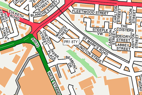
PR1 8TY lies on Spa Street in Preston. PR1 8TY is located in the City Centre electoral ward, within the local authority district of Preston and the English Parliamentary constituency of Preston. The Sub Integrated Care Board (ICB) Location is NHS Lancashire and South Cumbria ICB - 01E and the police force is Lancashire. This postcode has been in use since January 1980.


GetTheData
Source: OS OpenMap – Local (Ordnance Survey)
Source: OS VectorMap District (Ordnance Survey)
Licence: Open Government Licence (requires attribution)
| Easting | 352593 |
| Northing | 429898 |
| Latitude | 53.763264 |
| Longitude | -2.720614 |
GetTheData
Source: Open Postcode Geo
Licence: Open Government Licence
| Street | Spa Street |
| Town/City | Preston |
| Country | England |
| Postcode District | PR1 |
➜ See where PR1 is on a map ➜ Where is Preston? | |
GetTheData
Source: Land Registry Price Paid Data
Licence: Open Government Licence
Elevation or altitude of PR1 8TY as distance above sea level:
| Metres | Feet | |
|---|---|---|
| Elevation | 20m | 66ft |
Elevation is measured from the approximate centre of the postcode, to the nearest point on an OS contour line from OS Terrain 50, which has contour spacing of ten vertical metres.
➜ How high above sea level am I? Find the elevation of your current position using your device's GPS.
GetTheData
Source: Open Postcode Elevation
Licence: Open Government Licence
| Ward | City Centre |
| Constituency | Preston |
GetTheData
Source: ONS Postcode Database
Licence: Open Government Licence
| Water Lane | Ashton-on-ribble | 145m |
| Water Lane Viaduct (Water Lane) | Ashton-on-ribble | 168m |
| Water Lane (Wyre Street) | Ashton-on-ribble | 225m |
| Water Lane (Tulketh Brow) | Ashton-on-ribble | 228m |
| Swansea Street (Watery Lane) | Ashton-on-ribble | 248m |
| Preston Station | 1.1km |
| Lostock Hall Station | 4.9km |
| Bamber Bridge Station | 5.7km |
GetTheData
Source: NaPTAN
Licence: Open Government Licence
| Percentage of properties with Next Generation Access | 100.0% |
| Percentage of properties with Superfast Broadband | 100.0% |
| Percentage of properties with Ultrafast Broadband | 0.0% |
| Percentage of properties with Full Fibre Broadband | 0.0% |
Superfast Broadband is between 30Mbps and 300Mbps
Ultrafast Broadband is > 300Mbps
| Percentage of properties unable to receive 2Mbps | 0.0% |
| Percentage of properties unable to receive 5Mbps | 0.0% |
| Percentage of properties unable to receive 10Mbps | 0.0% |
| Percentage of properties unable to receive 30Mbps | 0.0% |
GetTheData
Source: Ofcom
Licence: Ofcom Terms of Use (requires attribution)
GetTheData
Source: ONS Postcode Database
Licence: Open Government Licence


➜ Get more ratings from the Food Standards Agency
GetTheData
Source: Food Standards Agency
Licence: FSA terms & conditions
| Last Collection | |||
|---|---|---|---|
| Location | Mon-Fri | Sat | Distance |
| Marsh Lane | 18:30 | 11:30 | 503m |
| Tulketh Road | 17:00 | 11:30 | 750m |
| St Peters | 17:30 | 11:30 | 755m |
GetTheData
Source: Dracos
Licence: Creative Commons Attribution-ShareAlike
The below table lists the International Territorial Level (ITL) codes (formerly Nomenclature of Territorial Units for Statistics (NUTS) codes) and Local Administrative Units (LAU) codes for PR1 8TY:
| ITL 1 Code | Name |
|---|---|
| TLD | North West (England) |
| ITL 2 Code | Name |
| TLD4 | Lancashire |
| ITL 3 Code | Name |
| TLD45 | Mid Lancashire |
| LAU 1 Code | Name |
| E07000123 | Preston |
GetTheData
Source: ONS Postcode Directory
Licence: Open Government Licence
The below table lists the Census Output Area (OA), Lower Layer Super Output Area (LSOA), and Middle Layer Super Output Area (MSOA) for PR1 8TY:
| Code | Name | |
|---|---|---|
| OA | E00128479 | |
| LSOA | E01025314 | Preston 012G |
| MSOA | E02005264 | Preston 012 |
GetTheData
Source: ONS Postcode Directory
Licence: Open Government Licence
| PR1 8TS | Wellington Street | 34m |
| PR1 8UA | West View Terrace | 71m |
| PR1 8TL | St Marks Road | 76m |
| PR1 8TR | Wellington Street | 81m |
| PR1 8UE | Cheviot Street | 89m |
| PR1 8UN | Beamont Drive | 94m |
| PR1 8TU | St Marks Place West | 106m |
| PR1 8UW | Kerr Place | 111m |
| PR1 8TQ | Wellington Street | 112m |
| PR2 2NL | Water Lane | 135m |
GetTheData
Source: Open Postcode Geo; Land Registry Price Paid Data
Licence: Open Government Licence