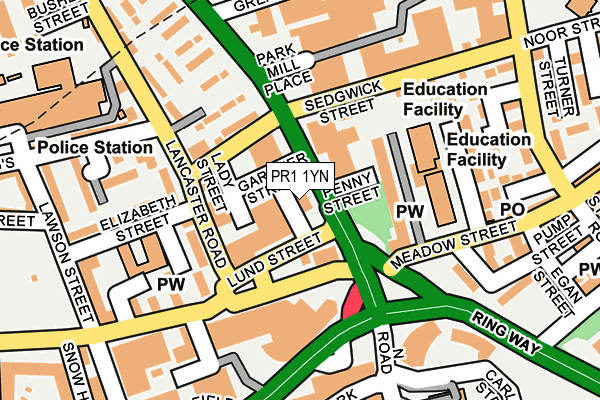
PR1 1YN is located in the City Centre electoral ward, within the local authority district of Preston and the English Parliamentary constituency of Preston. The Sub Integrated Care Board (ICB) Location is NHS Lancashire and South Cumbria ICB - 01E and the police force is Lancashire. This postcode has been in use since June 1997.


GetTheData
Source: OS OpenMap – Local (Ordnance Survey)
Source: OS VectorMap District (Ordnance Survey)
Licence: Open Government Licence (requires attribution)
| Easting | 354031 |
| Northing | 429928 |
| Latitude | 53.763663 |
| Longitude | -2.698807 |
GetTheData
Source: Open Postcode Geo
Licence: Open Government Licence
| Country | England |
| Postcode District | PR1 |
➜ See where PR1 is on a map ➜ Where is Preston? | |
GetTheData
Source: Land Registry Price Paid Data
Licence: Open Government Licence
Elevation or altitude of PR1 1YN as distance above sea level:
| Metres | Feet | |
|---|---|---|
| Elevation | 40m | 131ft |
Elevation is measured from the approximate centre of the postcode, to the nearest point on an OS contour line from OS Terrain 50, which has contour spacing of ten vertical metres.
➜ How high above sea level am I? Find the elevation of your current position using your device's GPS.
GetTheData
Source: Open Postcode Elevation
Licence: Open Government Licence
| Ward | City Centre |
| Constituency | Preston |
GetTheData
Source: ONS Postcode Database
Licence: Open Government Licence
| Gardner Street (North Road) | Preston City Centre | 18m |
| Gardner Street (North Road) | Preston City Centre | 30m |
| Gt George Street (North Road) | Preston City Centre | 179m |
| Gt Georges Street (North Road) | Preston City Centre | 250m |
| Ring Way | Preston City Centre | 272m |
| Preston Station | 1km |
| Lostock Hall Station | 4.4km |
| Bamber Bridge Station | 4.8km |
GetTheData
Source: NaPTAN
Licence: Open Government Licence
| Percentage of properties with Next Generation Access | 100.0% |
| Percentage of properties with Superfast Broadband | 100.0% |
| Percentage of properties with Ultrafast Broadband | 0.0% |
| Percentage of properties with Full Fibre Broadband | 0.0% |
Superfast Broadband is between 30Mbps and 300Mbps
Ultrafast Broadband is > 300Mbps
| Percentage of properties unable to receive 2Mbps | 0.0% |
| Percentage of properties unable to receive 5Mbps | 0.0% |
| Percentage of properties unable to receive 10Mbps | 0.0% |
| Percentage of properties unable to receive 30Mbps | 0.0% |
GetTheData
Source: Ofcom
Licence: Ofcom Terms of Use (requires attribution)
GetTheData
Source: ONS Postcode Database
Licence: Open Government Licence


➜ Get more ratings from the Food Standards Agency
GetTheData
Source: Food Standards Agency
Licence: FSA terms & conditions
| Last Collection | |||
|---|---|---|---|
| Location | Mon-Fri | Sat | Distance |
| Birley Street | 18:15 | 11:30 | 442m |
| Birley Street | 18:15 | 11:30 | 443m |
| Birley Street | 449m | ||
GetTheData
Source: Dracos
Licence: Creative Commons Attribution-ShareAlike
The below table lists the International Territorial Level (ITL) codes (formerly Nomenclature of Territorial Units for Statistics (NUTS) codes) and Local Administrative Units (LAU) codes for PR1 1YN:
| ITL 1 Code | Name |
|---|---|
| TLD | North West (England) |
| ITL 2 Code | Name |
| TLD4 | Lancashire |
| ITL 3 Code | Name |
| TLD45 | Mid Lancashire |
| LAU 1 Code | Name |
| E07000123 | Preston |
GetTheData
Source: ONS Postcode Directory
Licence: Open Government Licence
The below table lists the Census Output Area (OA), Lower Layer Super Output Area (LSOA), and Middle Layer Super Output Area (MSOA) for PR1 1YN:
| Code | Name | |
|---|---|---|
| OA | E00171996 | |
| LSOA | E01033223 | Preston 017F |
| MSOA | E02005269 | Preston 017 |
GetTheData
Source: ONS Postcode Directory
Licence: Open Government Licence
| PR1 1YD | Beckett Court | 100m |
| PR1 2PY | Lancaster Road North | 114m |
| PR1 1TT | St Ignatius Square | 120m |
| PR1 1TP | Sedgwick Street | 176m |
| PR1 2RR | Walker Street | 179m |
| PR1 2RX | Elizabeth Street | 192m |
| PR1 1TU | St Ignatius Place | 193m |
| PR1 1TR | Meadow Street | 196m |
| PR1 1UB | Shaw Street | 201m |
| PR1 2QP | Ormskirk Road | 208m |
GetTheData
Source: Open Postcode Geo; Land Registry Price Paid Data
Licence: Open Government Licence