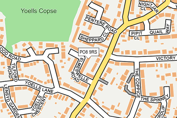
PO8 9RS lies on Elmeswelle Road in Waterlooville. PO8 9RS is located in the Horndean Catherington electoral ward, within the local authority district of East Hampshire and the English Parliamentary constituency of Meon Valley. The Sub Integrated Care Board (ICB) Location is NHS Hampshire and Isle of Wight ICB - D9Y0V and the police force is Hampshire. This postcode has been in use since January 1980.


GetTheData
Source: OS OpenMap – Local (Ordnance Survey)
Source: OS VectorMap District (Ordnance Survey)
Licence: Open Government Licence (requires attribution)
| Easting | 469095 |
| Northing | 112774 |
| Latitude | 50.910308 |
| Longitude | -1.018598 |
GetTheData
Source: Open Postcode Geo
Licence: Open Government Licence
| Street | Elmeswelle Road |
| Town/City | Waterlooville |
| Country | England |
| Postcode District | PO8 |
➜ See where PO8 is on a map ➜ Where is Horndean? | |
GetTheData
Source: Land Registry Price Paid Data
Licence: Open Government Licence
Elevation or altitude of PO8 9RS as distance above sea level:
| Metres | Feet | |
|---|---|---|
| Elevation | 70m | 230ft |
Elevation is measured from the approximate centre of the postcode, to the nearest point on an OS contour line from OS Terrain 50, which has contour spacing of ten vertical metres.
➜ How high above sea level am I? Find the elevation of your current position using your device's GPS.
GetTheData
Source: Open Postcode Elevation
Licence: Open Government Licence
| Ward | Horndean Catherington |
| Constituency | Meon Valley |
GetTheData
Source: ONS Postcode Database
Licence: Open Government Licence
| Victory Avenue (Frogmore Lane) | Causeway | 84m |
| Victory Avenue (Frogmore Lane) | Causeway | 103m |
| Yoells Lane (Frogmore Lane) | Lovedean | 144m |
| Elaine Gardens (Frogmore Lane) | Lovedean | 353m |
| Falcon Road (Stonechat Road) | Causeway | 395m |
| Rowlands Castle Station | 4.7km |
GetTheData
Source: NaPTAN
Licence: Open Government Licence
| Percentage of properties with Next Generation Access | 100.0% |
| Percentage of properties with Superfast Broadband | 100.0% |
| Percentage of properties with Ultrafast Broadband | 100.0% |
| Percentage of properties with Full Fibre Broadband | 0.0% |
Superfast Broadband is between 30Mbps and 300Mbps
Ultrafast Broadband is > 300Mbps
| Percentage of properties unable to receive 2Mbps | 0.0% |
| Percentage of properties unable to receive 5Mbps | 0.0% |
| Percentage of properties unable to receive 10Mbps | 0.0% |
| Percentage of properties unable to receive 30Mbps | 0.0% |
GetTheData
Source: Ofcom
Licence: Ofcom Terms of Use (requires attribution)
GetTheData
Source: ONS Postcode Database
Licence: Open Government Licence


➜ Get more ratings from the Food Standards Agency
GetTheData
Source: Food Standards Agency
Licence: FSA terms & conditions
| Last Collection | |||
|---|---|---|---|
| Location | Mon-Fri | Sat | Distance |
| Frogmore Lane | 17:30 | 12:15 | 153m |
| Stonechat Road | 17:15 | 12:00 | 450m |
| James Copse | 17:30 | 12:25 | 487m |
GetTheData
Source: Dracos
Licence: Creative Commons Attribution-ShareAlike
The below table lists the International Territorial Level (ITL) codes (formerly Nomenclature of Territorial Units for Statistics (NUTS) codes) and Local Administrative Units (LAU) codes for PO8 9RS:
| ITL 1 Code | Name |
|---|---|
| TLJ | South East (England) |
| ITL 2 Code | Name |
| TLJ3 | Hampshire and Isle of Wight |
| ITL 3 Code | Name |
| TLJ36 | Central Hampshire |
| LAU 1 Code | Name |
| E07000085 | East Hampshire |
GetTheData
Source: ONS Postcode Directory
Licence: Open Government Licence
The below table lists the Census Output Area (OA), Lower Layer Super Output Area (LSOA), and Middle Layer Super Output Area (MSOA) for PO8 9RS:
| Code | Name | |
|---|---|---|
| OA | E00114924 | |
| LSOA | E01022606 | East Hampshire 014A |
| MSOA | E02004710 | East Hampshire 014 |
GetTheData
Source: ONS Postcode Directory
Licence: Open Government Licence
| PO8 9RR | Elmeswelle Road | 53m |
| PO8 9SA | Eperston Road | 60m |
| PO8 9RB | Frogmore Lane | 77m |
| PO8 9HQ | Sheppard Close | 85m |
| PO8 9GH | Applegate Place | 110m |
| PO8 9SR | Yoells Lane | 112m |
| PO8 9TU | Loxwood Road | 153m |
| PO8 9HG | Pentere Road | 165m |
| PO8 9PX | Churchill Court | 166m |
| PO8 9YW | Pipit Close | 166m |
GetTheData
Source: Open Postcode Geo; Land Registry Price Paid Data
Licence: Open Government Licence