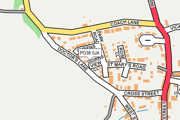
PO36 0JA lies on Downs View Close in Brading, Sandown. PO36 0JA is located in the Brading & St Helens electoral ward, within the unitary authority of Isle of Wight and the English Parliamentary constituency of Isle of Wight. The Sub Integrated Care Board (ICB) Location is NHS Hampshire and Isle of Wight ICB - D9Y0V and the police force is Hampshire. This postcode has been in use since January 1980.


GetTheData
Source: OS OpenMap – Local (Ordnance Survey)
Source: OS VectorMap District (Ordnance Survey)
Licence: Open Government Licence (requires attribution)
| Easting | 460372 |
| Northing | 87361 |
| Latitude | 50.682771 |
| Longitude | -1.146813 |
GetTheData
Source: Open Postcode Geo
Licence: Open Government Licence
| Street | Downs View Close |
| Locality | Brading |
| Town/City | Sandown |
| Country | England |
| Postcode District | PO36 |
➜ See where PO36 is on a map ➜ Where is Brading? | |
GetTheData
Source: Land Registry Price Paid Data
Licence: Open Government Licence
Elevation or altitude of PO36 0JA as distance above sea level:
| Metres | Feet | |
|---|---|---|
| Elevation | 20m | 66ft |
Elevation is measured from the approximate centre of the postcode, to the nearest point on an OS contour line from OS Terrain 50, which has contour spacing of ten vertical metres.
➜ How high above sea level am I? Find the elevation of your current position using your device's GPS.
GetTheData
Source: Open Postcode Elevation
Licence: Open Government Licence
| Ward | Brading & St Helens |
| Constituency | Isle Of Wight |
GetTheData
Source: ONS Postcode Database
Licence: Open Government Licence
2017 19 MAY £234,000 |
2017 13 FEB £235,000 |
2015 1 MAY £171,000 |
2008 20 MAR £210,000 |
2006 12 OCT £199,950 |
2001 15 OCT £125,000 |
2000 27 OCT £90,000 |
1998 30 APR £75,000 |
GetTheData
Source: HM Land Registry Price Paid Data
Licence: Contains HM Land Registry data © Crown copyright and database right 2025. This data is licensed under the Open Government Licence v3.0.
| Church (High Street) | Brading | 257m |
| Church (High Street) | Brading | 274m |
| Bull Ring (High Street) | Brading | 369m |
| Bull Ring (New Road) | Brading | 423m |
| Cricket Club (Rowborough Lane) | Brading | 521m |
| Brading Station | 0.8km |
| Sandown Station | 3.1km |
| Smallbrook Junction Station | 3.2km |
GetTheData
Source: NaPTAN
Licence: Open Government Licence
| Percentage of properties with Next Generation Access | 100.0% |
| Percentage of properties with Superfast Broadband | 100.0% |
| Percentage of properties with Ultrafast Broadband | 0.0% |
| Percentage of properties with Full Fibre Broadband | 0.0% |
Superfast Broadband is between 30Mbps and 300Mbps
Ultrafast Broadband is > 300Mbps
| Percentage of properties unable to receive 2Mbps | 0.0% |
| Percentage of properties unable to receive 5Mbps | 0.0% |
| Percentage of properties unable to receive 10Mbps | 0.0% |
| Percentage of properties unable to receive 30Mbps | 0.0% |
GetTheData
Source: Ofcom
Licence: Ofcom Terms of Use (requires attribution)
GetTheData
Source: ONS Postcode Database
Licence: Open Government Licence


➜ Get more ratings from the Food Standards Agency
GetTheData
Source: Food Standards Agency
Licence: FSA terms & conditions
| Last Collection | |||
|---|---|---|---|
| Location | Mon-Fri | Sat | Distance |
| Park Road | 16:30 | 10:45 | 58m |
| Brading Post Office | 16:30 | 11:00 | 379m |
| Lower Furlongs | 16:30 | 10:45 | 526m |
GetTheData
Source: Dracos
Licence: Creative Commons Attribution-ShareAlike
The below table lists the International Territorial Level (ITL) codes (formerly Nomenclature of Territorial Units for Statistics (NUTS) codes) and Local Administrative Units (LAU) codes for PO36 0JA:
| ITL 1 Code | Name |
|---|---|
| TLJ | South East (England) |
| ITL 2 Code | Name |
| TLJ3 | Hampshire and Isle of Wight |
| ITL 3 Code | Name |
| TLJ34 | Isle of Wight |
| LAU 1 Code | Name |
| E06000046 | Isle of Wight |
GetTheData
Source: ONS Postcode Directory
Licence: Open Government Licence
The below table lists the Census Output Area (OA), Lower Layer Super Output Area (LSOA), and Middle Layer Super Output Area (MSOA) for PO36 0JA:
| Code | Name | |
|---|---|---|
| OA | E00087321 | |
| LSOA | E01017289 | Isle of Wight 014A |
| MSOA | E02003594 | Isle of Wight 014 |
GetTheData
Source: ONS Postcode Directory
Licence: Open Government Licence
| PO36 0HU | Park Road | 59m |
| PO36 0JB | Queens Drive | 61m |
| PO36 0JE | Coach Lane | 84m |
| PO36 0JF | Kyngs Close | 128m |
| PO36 0HY | Rose Close | 128m |
| PO36 0HZ | Hawkins Close | 130m |
| PO36 0HT | Coach Lane | 145m |
| PO36 0HX | St Marys Road | 157m |
| PO36 0DN | West Street | 174m |
| PO36 0DL | Cross Street | 184m |
GetTheData
Source: Open Postcode Geo; Land Registry Price Paid Data
Licence: Open Government Licence