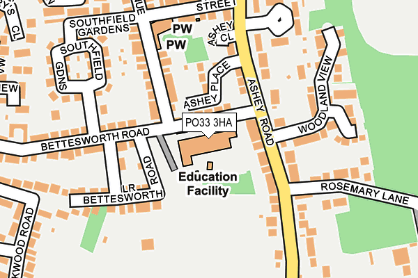
PO33 3HA is located in the Haylands & Swanmore electoral ward, within the unitary authority of Isle of Wight and the English Parliamentary constituency of Isle of Wight. The Sub Integrated Care Board (ICB) Location is NHS Hampshire and Isle of Wight ICB - D9Y0V and the police force is Hampshire. This postcode has been in use since November 2012.


GetTheData
Source: OS OpenMap – Local (Ordnance Survey)
Source: OS VectorMap District (Ordnance Survey)
Licence: Open Government Licence (requires attribution)
| Easting | 458843 |
| Northing | 91226 |
| Latitude | 50.717692 |
| Longitude | -1.167848 |
GetTheData
Source: Open Postcode Geo
Licence: Open Government Licence
| Country | England |
| Postcode District | PO33 |
➜ See where PO33 is on a map ➜ Where is Ryde? | |
GetTheData
Source: Land Registry Price Paid Data
Licence: Open Government Licence
Elevation or altitude of PO33 3HA as distance above sea level:
| Metres | Feet | |
|---|---|---|
| Elevation | 30m | 98ft |
Elevation is measured from the approximate centre of the postcode, to the nearest point on an OS contour line from OS Terrain 50, which has contour spacing of ten vertical metres.
➜ How high above sea level am I? Find the elevation of your current position using your device's GPS.
GetTheData
Source: Open Postcode Elevation
Licence: Open Government Licence
| Ward | Haylands & Swanmore |
| Constituency | Isle Of Wight |
GetTheData
Source: ONS Postcode Database
Licence: Open Government Licence
| Swanmore Middle School (Bettesworth Road) | Swanmore | 48m |
| Bettesworth Road | Haylands | 209m |
| Ashey Road Stores (Ashey Road) | Swanmore | 220m |
| Lake Huron (Bettesworth Road) | Haylands | 369m |
| Ryde Community Clinic (Pellhurst Road) | Ryde | 414m |
| Smallbrook Junction (Isle Of Wight Steam Railway | Westridge | 1,207m |
| Ryde St Johns Road Station | 1.1km |
| Smallbrook Junction Station | 1.2km |
| Ryde Esplanade Station | 1.8km |
GetTheData
Source: NaPTAN
Licence: Open Government Licence
GetTheData
Source: ONS Postcode Database
Licence: Open Government Licence


➜ Get more ratings from the Food Standards Agency
GetTheData
Source: Food Standards Agency
Licence: FSA terms & conditions
| Last Collection | |||
|---|---|---|---|
| Location | Mon-Fri | Sat | Distance |
| Upton Road | 17:45 | 12:00 | 376m |
| West Street Post Office | 17:45 | 11:45 | 532m |
| Haylands Post Office | 17:00 | 12:00 | 705m |
GetTheData
Source: Dracos
Licence: Creative Commons Attribution-ShareAlike
The below table lists the International Territorial Level (ITL) codes (formerly Nomenclature of Territorial Units for Statistics (NUTS) codes) and Local Administrative Units (LAU) codes for PO33 3HA:
| ITL 1 Code | Name |
|---|---|
| TLJ | South East (England) |
| ITL 2 Code | Name |
| TLJ3 | Hampshire and Isle of Wight |
| ITL 3 Code | Name |
| TLJ34 | Isle of Wight |
| LAU 1 Code | Name |
| E06000046 | Isle of Wight |
GetTheData
Source: ONS Postcode Directory
Licence: Open Government Licence
The below table lists the Census Output Area (OA), Lower Layer Super Output Area (LSOA), and Middle Layer Super Output Area (MSOA) for PO33 3HA:
| Code | Name | |
|---|---|---|
| OA | E00087285 | |
| LSOA | E01017282 | Isle of Wight 006A |
| MSOA | E02003586 | Isle of Wight 006 |
GetTheData
Source: ONS Postcode Directory
Licence: Open Government Licence
| PO33 2UY | Ashey Road | 79m |
| PO33 2WA | Ashey Place | 87m |
| PO33 3EJ | Bettesworth Road | 110m |
| PO33 2UT | Ashey Road | 128m |
| PO33 3EH | St Michaels Avenue | 132m |
| PO33 3EQ | Lower Bettesworth Road | 142m |
| PO33 2UU | Ashey Close | 143m |
| PO33 3EG | Lower Bettesworth Road | 148m |
| PO33 2UZ | Ashey Road | 183m |
| PO33 2UX | Rosemary Lane | 190m |
GetTheData
Source: Open Postcode Geo; Land Registry Price Paid Data
Licence: Open Government Licence