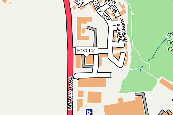
PO33 1QT lies on Cothey Way in Ryde. PO33 1QT is located in the Nettlestone & Seaview electoral ward, within the unitary authority of Isle of Wight and the English Parliamentary constituency of Isle of Wight. The Sub Integrated Care Board (ICB) Location is NHS Hampshire and Isle of Wight ICB - D9Y0V and the police force is Hampshire. This postcode has been in use since June 1999.


GetTheData
Source: OS OpenMap – Local (Ordnance Survey)
Source: OS VectorMap District (Ordnance Survey)
Licence: Open Government Licence (requires attribution)
| Easting | 460430 |
| Northing | 90677 |
| Latitude | 50.712581 |
| Longitude | -1.145450 |
GetTheData
Source: Open Postcode Geo
Licence: Open Government Licence
| Street | Cothey Way |
| Town/City | Ryde |
| Country | England |
| Postcode District | PO33 |
➜ See where PO33 is on a map ➜ Where is Ryde? | |
GetTheData
Source: Land Registry Price Paid Data
Licence: Open Government Licence
Elevation or altitude of PO33 1QT as distance above sea level:
| Metres | Feet | |
|---|---|---|
| Elevation | 40m | 131ft |
Elevation is measured from the approximate centre of the postcode, to the nearest point on an OS contour line from OS Terrain 50, which has contour spacing of ten vertical metres.
➜ How high above sea level am I? Find the elevation of your current position using your device's GPS.
GetTheData
Source: Open Postcode Elevation
Licence: Open Government Licence
| Ward | Nettlestone & Seaview |
| Constituency | Isle Of Wight |
GetTheData
Source: ONS Postcode Database
Licence: Open Government Licence
| Busy Bee Garden Centre (Brading Road) | Westridge | 321m |
| Westridge Cross (Great Preston Road) | Westridge | 326m |
| Westridge Cross (Great Preston Road) | Westridge | 327m |
| Busy Bee Garden Centre (Brading Road) | Westridge | 327m |
| Tesco (Store Approach Road) | Westridge | 364m |
| Smallbrook Junction (Isle Of Wight Steam Railway | Westridge | 657m |
| Smallbrook Junction Station | 0.6km |
| Ryde St Johns Road Station | 1.5km |
| Ryde Esplanade Station | 2.5km |
GetTheData
Source: NaPTAN
Licence: Open Government Licence
| Median download speed | 66.7Mbps |
| Average download speed | 63.7Mbps |
| Maximum download speed | 79.98Mbps |
| Median upload speed | 20.0Mbps |
| Average upload speed | 16.5Mbps |
| Maximum upload speed | 20.00Mbps |
GetTheData
Source: Ofcom
Licence: Ofcom Terms of Use (requires attribution)
GetTheData
Source: ONS Postcode Database
Licence: Open Government Licence


➜ Get more ratings from the Food Standards Agency
GetTheData
Source: Food Standards Agency
Licence: FSA terms & conditions
| Last Collection | |||
|---|---|---|---|
| Location | Mon-Fri | Sat | Distance |
| Pennyfeathers | 16:45 | 11:00 | 365m |
| Elmfield Post Office | 17:00 | 11:00 | 805m |
| High Park Road | 16:45 | 11:00 | 850m |
GetTheData
Source: Dracos
Licence: Creative Commons Attribution-ShareAlike
The below table lists the International Territorial Level (ITL) codes (formerly Nomenclature of Territorial Units for Statistics (NUTS) codes) and Local Administrative Units (LAU) codes for PO33 1QT:
| ITL 1 Code | Name |
|---|---|
| TLJ | South East (England) |
| ITL 2 Code | Name |
| TLJ3 | Hampshire and Isle of Wight |
| ITL 3 Code | Name |
| TLJ34 | Isle of Wight |
| LAU 1 Code | Name |
| E06000046 | Isle of Wight |
GetTheData
Source: ONS Postcode Directory
Licence: Open Government Licence
The below table lists the Census Output Area (OA), Lower Layer Super Output Area (LSOA), and Middle Layer Super Output Area (MSOA) for PO33 1QT:
| Code | Name | |
|---|---|---|
| OA | E00087636 | |
| LSOA | E01017351 | Isle of Wight 010D |
| MSOA | E02003590 | Isle of Wight 010 |
GetTheData
Source: ONS Postcode Directory
Licence: Open Government Licence
| PO33 1QW | Mulberry Way | 165m |
| PO33 1RF | Hornbeam Square | 179m |
| PO33 1QY | Cothey Way | 192m |
| PO33 1QN | Coppice End | 222m |
| PO33 1RE | Aspen Gardens | 237m |
| PO33 1AU | Bullen Road | 311m |
| PO33 1BB | Smallbrook Lane | 338m |
| PO33 1AT | Marlborough Road | 365m |
| PO33 1AY | Great Preston Road | 407m |
| PO33 1AS | Hayward Avenue | 449m |
GetTheData
Source: Open Postcode Geo; Land Registry Price Paid Data
Licence: Open Government Licence