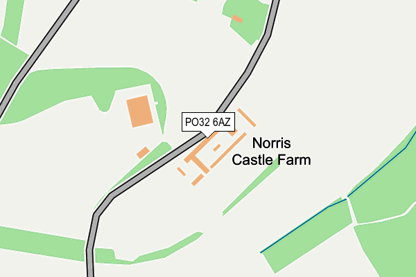
PO32 6AZ is located in the East Cowes electoral ward, within the unitary authority of Isle of Wight and the English Parliamentary constituency of Isle of Wight. The Sub Integrated Care Board (ICB) Location is NHS Hampshire and Isle of Wight ICB - D9Y0V and the police force is Hampshire. This postcode has been in use since January 1980.


GetTheData
Source: OS OpenMap – Local (Ordnance Survey)
Source: OS VectorMap District (Ordnance Survey)
Licence: Open Government Licence (requires attribution)
| Easting | 451484 |
| Northing | 95868 |
| Latitude | 50.760119 |
| Longitude | -1.271423 |
GetTheData
Source: Open Postcode Geo
Licence: Open Government Licence
| Country | England |
| Postcode District | PO32 |
➜ See where PO32 is on a map | |
GetTheData
Source: Land Registry Price Paid Data
Licence: Open Government Licence
Elevation or altitude of PO32 6AZ as distance above sea level:
| Metres | Feet | |
|---|---|---|
| Elevation | 40m | 131ft |
Elevation is measured from the approximate centre of the postcode, to the nearest point on an OS contour line from OS Terrain 50, which has contour spacing of ten vertical metres.
➜ How high above sea level am I? Find the elevation of your current position using your device's GPS.
GetTheData
Source: Open Postcode Elevation
Licence: Open Government Licence
| Ward | East Cowes |
| Constituency | Isle Of Wight |
GetTheData
Source: ONS Postcode Database
Licence: Open Government Licence
| John Nash Avenue | East Cowes | 940m |
| Connaught Road (York Avenue) | East Cowes | 941m |
| Connaught Road (York Avenue) | East Cowes | 965m |
| Osborne Cottage (York Avenue) | Osborne House | 978m |
| Osborne Cottage (York Avenue) | Osborne House | 996m |
GetTheData
Source: NaPTAN
Licence: Open Government Licence
GetTheData
Source: ONS Postcode Database
Licence: Open Government Licence


➜ Get more ratings from the Food Standards Agency
GetTheData
Source: Food Standards Agency
Licence: FSA terms & conditions
| Last Collection | |||
|---|---|---|---|
| Location | Mon-Fri | Sat | Distance |
| Old Road | 16:45 | 11:15 | 595m |
| York Avenue | 16:45 | 11:15 | 854m |
| Sylvan Avenue | 17:30 | 11:45 | 904m |
GetTheData
Source: Dracos
Licence: Creative Commons Attribution-ShareAlike
The below table lists the International Territorial Level (ITL) codes (formerly Nomenclature of Territorial Units for Statistics (NUTS) codes) and Local Administrative Units (LAU) codes for PO32 6AZ:
| ITL 1 Code | Name |
|---|---|
| TLJ | South East (England) |
| ITL 2 Code | Name |
| TLJ3 | Hampshire and Isle of Wight |
| ITL 3 Code | Name |
| TLJ34 | Isle of Wight |
| LAU 1 Code | Name |
| E06000046 | Isle of Wight |
GetTheData
Source: ONS Postcode Directory
Licence: Open Government Licence
The below table lists the Census Output Area (OA), Lower Layer Super Output Area (LSOA), and Middle Layer Super Output Area (MSOA) for PO32 6AZ:
| Code | Name | |
|---|---|---|
| OA | E00087409 | |
| LSOA | E01017307 | Isle of Wight 003A |
| MSOA | E02003583 | Isle of Wight 003 |
GetTheData
Source: ONS Postcode Directory
Licence: Open Government Licence
| PO32 6FH | Osborne Heights | 427m |
| PO32 6AY | New Barn Road | 454m |
| PO32 6EH | Oaks Close | 469m |
| PO32 6FE | Osborne Heights | 508m |
| PO32 6FF | Osborne Heights | 521m |
| PO32 6AS | Millfield Avenue | 537m |
| PO32 6EJ | Denton Gardens | 548m |
| PO32 6FR | Millfield Avenue | 571m |
| PO32 6AU | Old Road | 606m |
| PO32 6AR | Millfield Avenue | 628m |
GetTheData
Source: Open Postcode Geo; Land Registry Price Paid Data
Licence: Open Government Licence