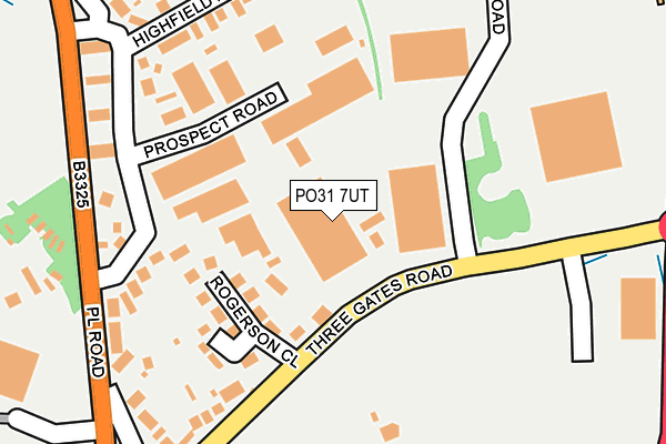
PO31 7UT is located in the Cowes South & Northwood electoral ward, within the unitary authority of Isle of Wight and the English Parliamentary constituency of Isle of Wight. The Sub Integrated Care Board (ICB) Location is NHS Hampshire and Isle of Wight ICB - D9Y0V and the police force is Hampshire. This postcode has been in use since January 1983.


GetTheData
Source: OS OpenMap – Local (Ordnance Survey)
Source: OS VectorMap District (Ordnance Survey)
Licence: Open Government Licence (requires attribution)
| Easting | 448818 |
| Northing | 94701 |
| Latitude | 50.749866 |
| Longitude | -1.309382 |
GetTheData
Source: Open Postcode Geo
Licence: Open Government Licence
| Country | England |
| Postcode District | PO31 |
➜ See where PO31 is on a map ➜ Where is Cowes? | |
GetTheData
Source: Land Registry Price Paid Data
Licence: Open Government Licence
Elevation or altitude of PO31 7UT as distance above sea level:
| Metres | Feet | |
|---|---|---|
| Elevation | 50m | 164ft |
Elevation is measured from the approximate centre of the postcode, to the nearest point on an OS contour line from OS Terrain 50, which has contour spacing of ten vertical metres.
➜ How high above sea level am I? Find the elevation of your current position using your device's GPS.
GetTheData
Source: Open Postcode Elevation
Licence: Open Government Licence
| Ward | Cowes South & Northwood |
| Constituency | Isle Of Wight |
GetTheData
Source: ONS Postcode Database
Licence: Open Government Licence
| Aldi (Three Gate Road) | Cowes | 184m |
| Aldi (Three Gates Road) | Cowes | 218m |
| Place Road (Three Gates Road) | Cowes | 247m |
| Three Gates Road (Place Road) | Cowes | 251m |
| Three Gates Road (Place Road) | Cowes | 255m |
GetTheData
Source: NaPTAN
Licence: Open Government Licence
Estimated total energy consumption in PO31 7UT by fuel type, 2015.
| Consumption (kWh) | 35,449 |
|---|---|
| Meter count | 6 |
| Mean (kWh/meter) | 5,908 |
| Median (kWh/meter) | 3,690 |
GetTheData
Source: Postcode level gas estimates: 2015 (experimental)
Source: Postcode level electricity estimates: 2015 (experimental)
Licence: Open Government Licence
GetTheData
Source: ONS Postcode Database
Licence: Open Government Licence


➜ Get more ratings from the Food Standards Agency
GetTheData
Source: Food Standards Agency
Licence: FSA terms & conditions
| Last Collection | |||
|---|---|---|---|
| Location | Mon-Fri | Sat | Distance |
| Seaview Road | 16:45 | 11:30 | 434m |
| Somerton | 17:15 | 10:30 | 458m |
| Pallance Road Post Office | 16:15 | 11:00 | 621m |
GetTheData
Source: Dracos
Licence: Creative Commons Attribution-ShareAlike
The below table lists the International Territorial Level (ITL) codes (formerly Nomenclature of Territorial Units for Statistics (NUTS) codes) and Local Administrative Units (LAU) codes for PO31 7UT:
| ITL 1 Code | Name |
|---|---|
| TLJ | South East (England) |
| ITL 2 Code | Name |
| TLJ3 | Hampshire and Isle of Wight |
| ITL 3 Code | Name |
| TLJ34 | Isle of Wight |
| LAU 1 Code | Name |
| E06000046 | Isle of Wight |
GetTheData
Source: ONS Postcode Directory
Licence: Open Government Licence
The below table lists the Census Output Area (OA), Lower Layer Super Output Area (LSOA), and Middle Layer Super Output Area (MSOA) for PO31 7UT:
| Code | Name | |
|---|---|---|
| OA | E00087387 | |
| LSOA | E01017302 | Isle of Wight 002B |
| MSOA | E02003582 | Isle of Wight 002 |
GetTheData
Source: ONS Postcode Directory
Licence: Open Government Licence
| PO31 7UJ | Rogerson Close | 132m |
| PO31 7UH | Three Gates Road | 170m |
| PO31 7AD | Prospect Road | 171m |
| PO31 7AE | Place Road | 200m |
| PO31 7BB | Place Side | 229m |
| PO31 7UF | Highfield Road | 251m |
| PO31 7US | Seaview Road | 270m |
| PO31 7UE | Place Road | 274m |
| PO31 7FG | The Chandlers | 348m |
| PO31 7UD | Broadfields Avenue | 353m |
GetTheData
Source: Open Postcode Geo; Land Registry Price Paid Data
Licence: Open Government Licence