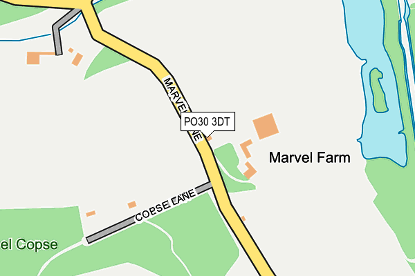
PO30 3DT lies on Marvel Lane in Newport. PO30 3DT is located in the Mountjoy & Shide electoral ward, within the unitary authority of Isle of Wight and the English Parliamentary constituency of Isle of Wight. The Sub Integrated Care Board (ICB) Location is NHS Hampshire and Isle of Wight ICB - D9Y0V and the police force is Hampshire. This postcode has been in use since January 1980.


GetTheData
Source: OS OpenMap – Local (Ordnance Survey)
Source: OS VectorMap District (Ordnance Survey)
Licence: Open Government Licence (requires attribution)
| Easting | 449965 |
| Northing | 87067 |
| Latitude | 50.681123 |
| Longitude | -1.294156 |
GetTheData
Source: Open Postcode Geo
Licence: Open Government Licence
| Street | Marvel Lane |
| Town/City | Newport |
| Country | England |
| Postcode District | PO30 |
➜ See where PO30 is on a map | |
GetTheData
Source: Land Registry Price Paid Data
Licence: Open Government Licence
Elevation or altitude of PO30 3DT as distance above sea level:
| Metres | Feet | |
|---|---|---|
| Elevation | 30m | 98ft |
Elevation is measured from the approximate centre of the postcode, to the nearest point on an OS contour line from OS Terrain 50, which has contour spacing of ten vertical metres.
➜ How high above sea level am I? Find the elevation of your current position using your device's GPS.
GetTheData
Source: Open Postcode Elevation
Licence: Open Government Licence
| Ward | Mountjoy & Shide |
| Constituency | Isle Of Wight |
GetTheData
Source: ONS Postcode Database
Licence: Open Government Licence
| Standen House (Blackwater Road) | Blackwater | 481m |
| Standen House (Blackwater Road) | Blackwater | 510m |
| West Standen (Blackwater Road) | Shide | 638m |
| West Standen (Blackwater Road) | Shide | 683m |
| Blackwater Corner (Blackwater Road) | Blackwater | 884m |
GetTheData
Source: NaPTAN
Licence: Open Government Licence
| Percentage of properties with Next Generation Access | 100.0% |
| Percentage of properties with Superfast Broadband | 50.0% |
| Percentage of properties with Ultrafast Broadband | 0.0% |
| Percentage of properties with Full Fibre Broadband | 0.0% |
Superfast Broadband is between 30Mbps and 300Mbps
Ultrafast Broadband is > 300Mbps
| Percentage of properties unable to receive 2Mbps | 0.0% |
| Percentage of properties unable to receive 5Mbps | 0.0% |
| Percentage of properties unable to receive 10Mbps | 0.0% |
| Percentage of properties unable to receive 30Mbps | 50.0% |
GetTheData
Source: Ofcom
Licence: Ofcom Terms of Use (requires attribution)
GetTheData
Source: ONS Postcode Database
Licence: Open Government Licence


➜ Get more ratings from the Food Standards Agency
GetTheData
Source: Food Standards Agency
Licence: FSA terms & conditions
| Last Collection | |||
|---|---|---|---|
| Location | Mon-Fri | Sat | Distance |
| Watergate Road | 17:00 | 12:00 | 1,063m |
| Blackwater | 16:45 | 10:15 | 1,124m |
| Whitecroft | 17:00 | 10:00 | 1,151m |
GetTheData
Source: Dracos
Licence: Creative Commons Attribution-ShareAlike
The below table lists the International Territorial Level (ITL) codes (formerly Nomenclature of Territorial Units for Statistics (NUTS) codes) and Local Administrative Units (LAU) codes for PO30 3DT:
| ITL 1 Code | Name |
|---|---|
| TLJ | South East (England) |
| ITL 2 Code | Name |
| TLJ3 | Hampshire and Isle of Wight |
| ITL 3 Code | Name |
| TLJ34 | Isle of Wight |
| LAU 1 Code | Name |
| E06000046 | Isle of Wight |
GetTheData
Source: ONS Postcode Directory
Licence: Open Government Licence
The below table lists the Census Output Area (OA), Lower Layer Super Output Area (LSOA), and Middle Layer Super Output Area (MSOA) for PO30 3DT:
| Code | Name | |
|---|---|---|
| OA | E00087476 | |
| LSOA | E01017321 | Isle of Wight 011D |
| MSOA | E02003591 | Isle of Wight 011 |
GetTheData
Source: ONS Postcode Directory
Licence: Open Government Licence
| PO30 1YP | Watergate Road | 350m |
| PO30 3BD | Blackwater Road | 565m |
| PO30 1YR | Nunnery Lane | 607m |
| PO30 3DS | Marvel Lane | 694m |
| PO30 3BE | Blackwater Road | 797m |
| PO30 3BS | Sandy Lane | 855m |
| PO30 1XP | Watergate Road | 856m |
| PO30 3BU | Sandy Close | 886m |
| PO30 3EA | Sandy Lane | 901m |
| PO30 3BF | Whitecroft Park | 985m |
GetTheData
Source: Open Postcode Geo; Land Registry Price Paid Data
Licence: Open Government Licence