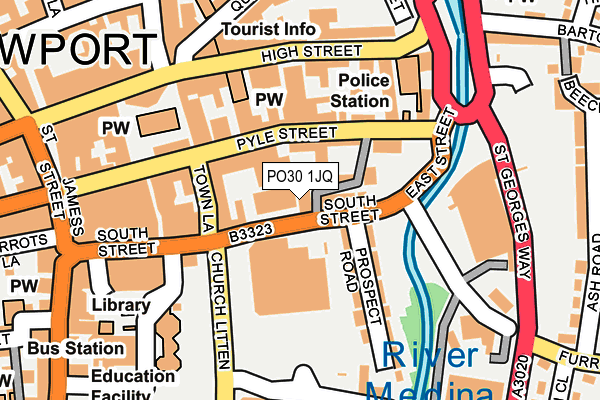
PO30 1JQ lies on South Street in Newport. PO30 1JQ is located in the Newport Central electoral ward, within the unitary authority of Isle of Wight and the English Parliamentary constituency of Isle of Wight. The Sub Integrated Care Board (ICB) Location is NHS Hampshire and Isle of Wight ICB - D9Y0V and the police force is Hampshire. This postcode has been in use since January 1980.


GetTheData
Source: OS OpenMap – Local (Ordnance Survey)
Source: OS VectorMap District (Ordnance Survey)
Licence: Open Government Licence (requires attribution)
| Easting | 450116 |
| Northing | 89067 |
| Latitude | 50.699094 |
| Longitude | -1.291748 |
GetTheData
Source: Open Postcode Geo
Licence: Open Government Licence
| Street | South Street |
| Town/City | Newport |
| Country | England |
| Postcode District | PO30 |
➜ See where PO30 is on a map ➜ Where is Newport? | |
GetTheData
Source: Land Registry Price Paid Data
Licence: Open Government Licence
Elevation or altitude of PO30 1JQ as distance above sea level:
| Metres | Feet | |
|---|---|---|
| Elevation | 10m | 33ft |
Elevation is measured from the approximate centre of the postcode, to the nearest point on an OS contour line from OS Terrain 50, which has contour spacing of ten vertical metres.
➜ How high above sea level am I? Find the elevation of your current position using your device's GPS.
GetTheData
Source: Open Postcode Elevation
Licence: Open Government Licence
| Ward | Newport Central |
| Constituency | Isle Of Wight |
GetTheData
Source: ONS Postcode Database
Licence: Open Government Licence
43, SOUTH STREET, NEWPORT, PO30 1JQ 2001 29 JUN £170,000 |
GetTheData
Source: HM Land Registry Price Paid Data
Licence: Contains HM Land Registry data © Crown copyright and database right 2025. This data is licensed under the Open Government Licence v3.0.
| Test Centre (Medina Avenue) | Newport | 326m |
| Furlongs Bottom (Furlongs) | Pan | 369m |
| Furlongs Bottom (Furrlongs) | Pan | 373m |
| Lugley Street (St James Street) | Newport | 386m |
| Barton Road | Barton | 390m |
GetTheData
Source: NaPTAN
Licence: Open Government Licence
| Median download speed | 50.0Mbps |
| Average download speed | 48.9Mbps |
| Maximum download speed | 80.00Mbps |
| Median upload speed | 10.9Mbps |
| Average upload speed | 11.2Mbps |
| Maximum upload speed | 20.00Mbps |
GetTheData
Source: Ofcom
Licence: Ofcom Terms of Use (requires attribution)
Estimated total energy consumption in PO30 1JQ by fuel type, 2015.
| Consumption (kWh) | 123,679 |
|---|---|
| Meter count | 22 |
| Mean (kWh/meter) | 5,622 |
| Median (kWh/meter) | 2,923 |
| Consumption (kWh) | 35,256 |
|---|---|
| Meter count | 21 |
| Mean (kWh/meter) | 1,679 |
| Median (kWh/meter) | 1,505 |
GetTheData
Source: Postcode level gas estimates: 2015 (experimental)
Source: Postcode level electricity estimates: 2015 (experimental)
Licence: Open Government Licence
GetTheData
Source: ONS Postcode Database
Licence: Open Government Licence


➜ Get more ratings from the Food Standards Agency
GetTheData
Source: Food Standards Agency
Licence: FSA terms & conditions
| Last Collection | |||
|---|---|---|---|
| Location | Mon-Fri | Sat | Distance |
| Town Hall | 17:30 | 12:30 | 161m |
| St Thomas Square | 17:15 | 12:00 | 162m |
| Town Hall | 17:30 | 12:30 | 162m |
GetTheData
Source: Dracos
Licence: Creative Commons Attribution-ShareAlike
The below table lists the International Territorial Level (ITL) codes (formerly Nomenclature of Territorial Units for Statistics (NUTS) codes) and Local Administrative Units (LAU) codes for PO30 1JQ:
| ITL 1 Code | Name |
|---|---|
| TLJ | South East (England) |
| ITL 2 Code | Name |
| TLJ3 | Hampshire and Isle of Wight |
| ITL 3 Code | Name |
| TLJ34 | Isle of Wight |
| LAU 1 Code | Name |
| E06000046 | Isle of Wight |
GetTheData
Source: ONS Postcode Directory
Licence: Open Government Licence
The below table lists the Census Output Area (OA), Lower Layer Super Output Area (LSOA), and Middle Layer Super Output Area (MSOA) for PO30 1JQ:
| Code | Name | |
|---|---|---|
| OA | E00087492 | |
| LSOA | E01017326 | Isle of Wight 009C |
| MSOA | E02003589 | Isle of Wight 009 |
GetTheData
Source: ONS Postcode Directory
Licence: Open Government Licence
| PO30 1JW | Pyle Street | 62m |
| PO30 1JU | Town Lane | 80m |
| PO30 1AP | Pyle Street | 86m |
| PO30 1AR | Town Lane | 92m |
| PO30 1AG | Pyle Street | 108m |
| PO30 1JA | Pyle Street | 115m |
| PO30 1JH | Prospect Road | 124m |
| PO30 1SS | High Street | 125m |
| PO30 1SN | St Thomas Square | 134m |
| PO30 1SL | St Thomas Square | 147m |
GetTheData
Source: Open Postcode Geo; Land Registry Price Paid Data
Licence: Open Government Licence