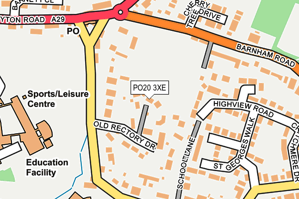
PO20 3XE lies on Old Rectory Drive in Eastergate, Chichester. PO20 3XE is located in the Barnham electoral ward, within the local authority district of Arun and the English Parliamentary constituency of Arundel and South Downs. The Sub Integrated Care Board (ICB) Location is NHS Sussex ICB - 70F and the police force is Sussex. This postcode has been in use since July 2013.


GetTheData
Source: OS OpenMap – Local (Ordnance Survey)
Source: OS VectorMap District (Ordnance Survey)
Licence: Open Government Licence (requires attribution)
| Easting | 494462 |
| Northing | 105416 |
| Latitude | 50.840571 |
| Longitude | -0.659780 |
GetTheData
Source: Open Postcode Geo
Licence: Open Government Licence
| Street | Old Rectory Drive |
| Locality | Eastergate |
| Town/City | Chichester |
| Country | England |
| Postcode District | PO20 |
➜ See where PO20 is on a map ➜ Where is Eastergate? | |
GetTheData
Source: Land Registry Price Paid Data
Licence: Open Government Licence
Elevation or altitude of PO20 3XE as distance above sea level:
| Metres | Feet | |
|---|---|---|
| Elevation | 10m | 33ft |
Elevation is measured from the approximate centre of the postcode, to the nearest point on an OS contour line from OS Terrain 50, which has contour spacing of ten vertical metres.
➜ How high above sea level am I? Find the elevation of your current position using your device's GPS.
GetTheData
Source: Open Postcode Elevation
Licence: Open Government Licence
| Ward | Barnham |
| Constituency | Arundel And South Downs |
GetTheData
Source: ONS Postcode Database
Licence: Open Government Licence
4, ABERCORN WALK, EASTERGATE, CHICHESTER, PO20 3XE 2024 19 JAN £905,000 |
2, ABERCORN WALK, EASTERGATE, CHICHESTER, PO20 3XE 2021 3 MAR £840,000 |
4, ABERCORN WALK, EASTERGATE, CHICHESTER, PO20 3XE 2020 22 OCT £770,000 |
1, ABERCORN WALK, EASTERGATE, CHICHESTER, PO20 3XE 2020 28 JAN £830,000 |
4, ABERCORN WALK, EASTERGATE, CHICHESTER, PO20 3XE 2013 4 NOV £725,950 |
3, ABERCORN WALK, EASTERGATE, CHICHESTER, PO20 3XE 2013 23 AUG £698,950 |
1, ABERCORN WALK, EASTERGATE, CHICHESTER, PO20 3XE 2013 28 JUN £682,950 |
2, ABERCORN WALK, EASTERGATE, CHICHESTER, PO20 3XE 2013 28 JUN £690,000 |
GetTheData
Source: HM Land Registry Price Paid Data
Licence: Contains HM Land Registry data © Crown copyright and database right 2025. This data is licensed under the Open Government Licence v3.0.
| War Memorial (Barnham Road) | Eastergate | 148m |
| War Memorial (Barnham Road) | Eastergate | 165m |
| Collins Close (Fontwell Avenue) | Eastergate | 215m |
| Collins Close (Fontwell Avenue) | Eastergate | 224m |
| Barnett Close (A29) | Westergate | 272m |
| Barnham Station | 1.8km |
GetTheData
Source: NaPTAN
Licence: Open Government Licence
| Percentage of properties with Next Generation Access | 100.0% |
| Percentage of properties with Superfast Broadband | 100.0% |
| Percentage of properties with Ultrafast Broadband | 0.0% |
| Percentage of properties with Full Fibre Broadband | 0.0% |
Superfast Broadband is between 30Mbps and 300Mbps
Ultrafast Broadband is > 300Mbps
| Percentage of properties unable to receive 2Mbps | 0.0% |
| Percentage of properties unable to receive 5Mbps | 0.0% |
| Percentage of properties unable to receive 10Mbps | 0.0% |
| Percentage of properties unable to receive 30Mbps | 0.0% |
GetTheData
Source: Ofcom
Licence: Ofcom Terms of Use (requires attribution)
GetTheData
Source: ONS Postcode Database
Licence: Open Government Licence


➜ Get more ratings from the Food Standards Agency
GetTheData
Source: Food Standards Agency
Licence: FSA terms & conditions
| Last Collection | |||
|---|---|---|---|
| Location | Mon-Fri | Sat | Distance |
| Aldingbourne Post Office | 16:30 | 11:00 | 1,221m |
| Eastergate Lane | 16:00 | 10:30 | 1,231m |
| Barnham Post Office | 16:15 | 11:00 | 1,647m |
GetTheData
Source: Dracos
Licence: Creative Commons Attribution-ShareAlike
The below table lists the International Territorial Level (ITL) codes (formerly Nomenclature of Territorial Units for Statistics (NUTS) codes) and Local Administrative Units (LAU) codes for PO20 3XE:
| ITL 1 Code | Name |
|---|---|
| TLJ | South East (England) |
| ITL 2 Code | Name |
| TLJ2 | Surrey, East and West Sussex |
| ITL 3 Code | Name |
| TLJ27 | West Sussex (South West) |
| LAU 1 Code | Name |
| E07000224 | Arun |
GetTheData
Source: ONS Postcode Directory
Licence: Open Government Licence
The below table lists the Census Output Area (OA), Lower Layer Super Output Area (LSOA), and Middle Layer Super Output Area (MSOA) for PO20 3XE:
| Code | Name | |
|---|---|---|
| OA | E00160096 | |
| LSOA | E01031397 | Arun 003E |
| MSOA | E02006544 | Arun 003 |
GetTheData
Source: ONS Postcode Directory
Licence: Open Government Licence
| PO20 3XH | Old Rectory Drive | 61m |
| PO20 3UU | School Lane | 92m |
| PO20 3UT | Church Lane | 137m |
| PO20 3UR | Church Lane | 150m |
| PO20 3XU | St Georges Walk | 151m |
| PO20 3RP | Barnham Road | 168m |
| PO20 3XB | Highview Road | 169m |
| PO20 3XS | St Georges Walk | 181m |
| PO20 3RR | Cherry Tree Drive | 223m |
| PO20 3XT | St Georges Walk | 225m |
GetTheData
Source: Open Postcode Geo; Land Registry Price Paid Data
Licence: Open Government Licence