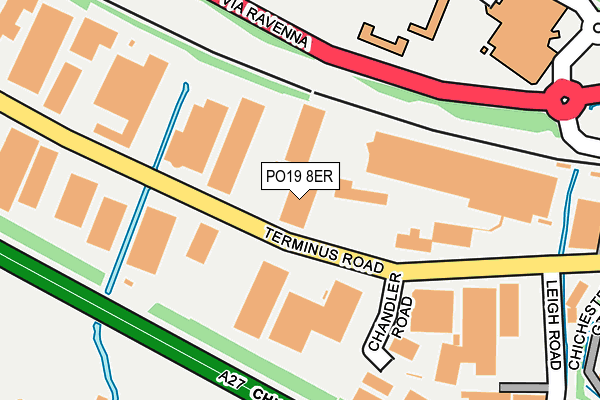
PO19 8ER is located in the Chichester Central electoral ward, within the local authority district of Chichester and the English Parliamentary constituency of Chichester. The Sub Integrated Care Board (ICB) Location is NHS Sussex ICB - 70F and the police force is Sussex. This postcode has been in use since June 2002.


GetTheData
Source: OS OpenMap – Local (Ordnance Survey)
Source: OS VectorMap District (Ordnance Survey)
Licence: Open Government Licence (requires attribution)
| Easting | 485295 |
| Northing | 104285 |
| Latitude | 50.831825 |
| Longitude | -0.790204 |
GetTheData
Source: Open Postcode Geo
Licence: Open Government Licence
| Country | England |
| Postcode District | PO19 |
➜ See where PO19 is on a map ➜ Where is Chichester? | |
GetTheData
Source: Land Registry Price Paid Data
Licence: Open Government Licence
Elevation or altitude of PO19 8ER as distance above sea level:
| Metres | Feet | |
|---|---|---|
| Elevation | 10m | 33ft |
Elevation is measured from the approximate centre of the postcode, to the nearest point on an OS contour line from OS Terrain 50, which has contour spacing of ten vertical metres.
➜ How high above sea level am I? Find the elevation of your current position using your device's GPS.
GetTheData
Source: Open Postcode Elevation
Licence: Open Government Licence
| Ward | Chichester Central |
| Constituency | Chichester |
GetTheData
Source: ONS Postcode Database
Licence: Open Government Licence
| Leisure Centre (Via Ravenna) | Chichester | 160m |
| Leisure Centre (Via Ravenna) | Chichester | 211m |
| Chichester Gate | Chichester | 402m |
| Parklands Road (Westgate) | Chichester | 496m |
| Sherborne Road (Westgate) | Chichester | 500m |
| Chichester Station | 0.6km |
| Fishbourne Station | 1.9km |
| Bosham Station | 4.2km |
GetTheData
Source: NaPTAN
Licence: Open Government Licence
GetTheData
Source: ONS Postcode Database
Licence: Open Government Licence


➜ Get more ratings from the Food Standards Agency
GetTheData
Source: Food Standards Agency
Licence: FSA terms & conditions
| Last Collection | |||
|---|---|---|---|
| Location | Mon-Fri | Sat | Distance |
| Terminus Road | 17:30 | 11:40 | 173m |
| Waitrose Store | 17:30 | 12:30 | 422m |
| Parklands Road Westgate | 17:30 | 12:10 | 557m |
GetTheData
Source: Dracos
Licence: Creative Commons Attribution-ShareAlike
The below table lists the International Territorial Level (ITL) codes (formerly Nomenclature of Territorial Units for Statistics (NUTS) codes) and Local Administrative Units (LAU) codes for PO19 8ER:
| ITL 1 Code | Name |
|---|---|
| TLJ | South East (England) |
| ITL 2 Code | Name |
| TLJ2 | Surrey, East and West Sussex |
| ITL 3 Code | Name |
| TLJ27 | West Sussex (South West) |
| LAU 1 Code | Name |
| E07000225 | Chichester |
GetTheData
Source: ONS Postcode Directory
Licence: Open Government Licence
The below table lists the Census Output Area (OA), Lower Layer Super Output Area (LSOA), and Middle Layer Super Output Area (MSOA) for PO19 8ER:
| Code | Name | |
|---|---|---|
| OA | E00160593 | |
| LSOA | E01031490 | Chichester 010D |
| MSOA | E02006570 | Chichester 010 |
GetTheData
Source: ONS Postcode Directory
Licence: Open Government Licence
| PO19 8TX | Terminus Road | 132m |
| PO19 3EY | Tannery Close | 457m |
| PO19 3HA | Westgate | 469m |
| PO19 3HB | Westgate | 475m |
| PO19 8DR | Canal Place | 481m |
| PO19 8DS | Canal Place | 504m |
| PO19 3EP | St Bartholomews Close | 509m |
| PO19 3DQ | Mount Lane | 519m |
| PO19 3HH | Westgate | 525m |
| PO19 8RQ | Croy Close | 548m |
GetTheData
Source: Open Postcode Geo; Land Registry Price Paid Data
Licence: Open Government Licence