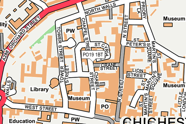
PO19 1BT lies on Chapel Street in Chichester. PO19 1BT is located in the Chichester Central electoral ward, within the local authority district of Chichester and the English Parliamentary constituency of Chichester. The Sub Integrated Care Board (ICB) Location is NHS Sussex ICB - 70F and the police force is Sussex. This postcode has been in use since October 1984.


GetTheData
Source: OS OpenMap – Local (Ordnance Survey)
Source: OS VectorMap District (Ordnance Survey)
Licence: Open Government Licence (requires attribution)
| Easting | 485998 |
| Northing | 105003 |
| Latitude | 50.838176 |
| Longitude | -0.780056 |
GetTheData
Source: Open Postcode Geo
Licence: Open Government Licence
| Street | Chapel Street |
| Town/City | Chichester |
| Country | England |
| Postcode District | PO19 |
➜ See where PO19 is on a map ➜ Where is Chichester? | |
GetTheData
Source: Land Registry Price Paid Data
Licence: Open Government Licence
Elevation or altitude of PO19 1BT as distance above sea level:
| Metres | Feet | |
|---|---|---|
| Elevation | 10m | 33ft |
Elevation is measured from the approximate centre of the postcode, to the nearest point on an OS contour line from OS Terrain 50, which has contour spacing of ten vertical metres.
➜ How high above sea level am I? Find the elevation of your current position using your device's GPS.
GetTheData
Source: Open Postcode Elevation
Licence: Open Government Licence
| Ward | Chichester Central |
| Constituency | Chichester |
GetTheData
Source: ONS Postcode Database
Licence: Open Government Licence
| Cathedral (West Street) | Chichester | 163m |
| Cathedral (West Street) | Chichester | 178m |
| Cathedral (West Street) | Chichester | 178m |
| Cathedral (West Street) | Chichester | 179m |
| Cathedral (West Street) | Chichester | 201m |
| Chichester Station | 0.7km |
| Fishbourne Station | 2.5km |
| Bosham Station | 4.8km |
GetTheData
Source: NaPTAN
Licence: Open Government Licence
| Percentage of properties with Next Generation Access | 100.0% |
| Percentage of properties with Superfast Broadband | 100.0% |
| Percentage of properties with Ultrafast Broadband | 100.0% |
| Percentage of properties with Full Fibre Broadband | 0.0% |
Superfast Broadband is between 30Mbps and 300Mbps
Ultrafast Broadband is > 300Mbps
| Percentage of properties unable to receive 2Mbps | 0.0% |
| Percentage of properties unable to receive 5Mbps | 0.0% |
| Percentage of properties unable to receive 10Mbps | 0.0% |
| Percentage of properties unable to receive 30Mbps | 0.0% |
GetTheData
Source: Ofcom
Licence: Ofcom Terms of Use (requires attribution)
GetTheData
Source: ONS Postcode Database
Licence: Open Government Licence


➜ Get more ratings from the Food Standards Agency
GetTheData
Source: Food Standards Agency
Licence: FSA terms & conditions
| Last Collection | |||
|---|---|---|---|
| Location | Mon-Fri | Sat | Distance |
| North Street | 18:30 | 12:30 | 112m |
| North Street | 18:30 | 12:30 | 112m |
| The Library | 17:15 | 12:15 | 115m |
GetTheData
Source: Dracos
Licence: Creative Commons Attribution-ShareAlike
The below table lists the International Territorial Level (ITL) codes (formerly Nomenclature of Territorial Units for Statistics (NUTS) codes) and Local Administrative Units (LAU) codes for PO19 1BT:
| ITL 1 Code | Name |
|---|---|
| TLJ | South East (England) |
| ITL 2 Code | Name |
| TLJ2 | Surrey, East and West Sussex |
| ITL 3 Code | Name |
| TLJ27 | West Sussex (South West) |
| LAU 1 Code | Name |
| E07000225 | Chichester |
GetTheData
Source: ONS Postcode Directory
Licence: Open Government Licence
The below table lists the Census Output Area (OA), Lower Layer Super Output Area (LSOA), and Middle Layer Super Output Area (MSOA) for PO19 1BT:
| Code | Name | |
|---|---|---|
| OA | E00160582 | |
| LSOA | E01031490 | Chichester 010D |
| MSOA | E02006570 | Chichester 010 |
GetTheData
Source: ONS Postcode Directory
Licence: Open Government Licence
| PO19 1AW | St Cyriacs | 20m |
| PO19 1LH | Crane Street | 26m |
| PO19 1BS | Providence Place | 28m |
| PO19 1AX | The Providence | 43m |
| PO19 1AN | St Cyriacs | 48m |
| PO19 1QL | Tower Street | 65m |
| PO19 1BU | Chapel Street | 77m |
| PO19 1DL | Chapel Street | 83m |
| PO19 1LX | North Street | 98m |
| PO19 1LP | North Street | 107m |
GetTheData
Source: Open Postcode Geo; Land Registry Price Paid Data
Licence: Open Government Licence