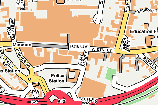
PO16 0JW is located in the Fareham East electoral ward, within the local authority district of Fareham and the English Parliamentary constituency of Fareham. The Sub Integrated Care Board (ICB) Location is NHS Hampshire and Isle of Wight ICB - D9Y0V and the police force is Hampshire. This postcode has been in use since January 1980.


GetTheData
Source: OS OpenMap – Local (Ordnance Survey)
Source: OS VectorMap District (Ordnance Survey)
Licence: Open Government Licence (requires attribution)
| Easting | 458078 |
| Northing | 106179 |
| Latitude | 50.852221 |
| Longitude | -1.176325 |
GetTheData
Source: Open Postcode Geo
Licence: Open Government Licence
| Country | England |
| Postcode District | PO16 |
➜ See where PO16 is on a map ➜ Where is Fareham? | |
GetTheData
Source: Land Registry Price Paid Data
Licence: Open Government Licence
Elevation or altitude of PO16 0JW as distance above sea level:
| Metres | Feet | |
|---|---|---|
| Elevation | 10m | 33ft |
Elevation is measured from the approximate centre of the postcode, to the nearest point on an OS contour line from OS Terrain 50, which has contour spacing of ten vertical metres.
➜ How high above sea level am I? Find the elevation of your current position using your device's GPS.
GetTheData
Source: Open Postcode Elevation
Licence: Open Government Licence
| Ward | Fareham East |
| Constituency | Fareham |
GetTheData
Source: ONS Postcode Database
Licence: Open Government Licence
| Quay Street (West Street) | Fareham | 68m |
| Shopping Centre (West Street) | Fareham | 192m |
| Library (Off Osborn Road) | Wallington | 223m |
| High Street | Fareham | 230m |
| High Street | Fareham | 252m |
| Fareham Station | 1.1km |
| Portchester Station | 3.7km |
GetTheData
Source: NaPTAN
Licence: Open Government Licence
GetTheData
Source: ONS Postcode Database
Licence: Open Government Licence


➜ Get more ratings from the Food Standards Agency
GetTheData
Source: Food Standards Agency
Licence: FSA terms & conditions
| Last Collection | |||
|---|---|---|---|
| Location | Mon-Fri | Sat | Distance |
| West Street (Stamped) | 17:30 | 12:15 | 79m |
| West Street (Franked) | 17:30 | 12:15 | 79m |
| Fareham Library | 16:45 | 12:15 | 203m |
GetTheData
Source: Dracos
Licence: Creative Commons Attribution-ShareAlike
The below table lists the International Territorial Level (ITL) codes (formerly Nomenclature of Territorial Units for Statistics (NUTS) codes) and Local Administrative Units (LAU) codes for PO16 0JW:
| ITL 1 Code | Name |
|---|---|
| TLJ | South East (England) |
| ITL 2 Code | Name |
| TLJ3 | Hampshire and Isle of Wight |
| ITL 3 Code | Name |
| TLJ35 | South Hampshire |
| LAU 1 Code | Name |
| E07000087 | Fareham |
GetTheData
Source: ONS Postcode Directory
Licence: Open Government Licence
The below table lists the Census Output Area (OA), Lower Layer Super Output Area (LSOA), and Middle Layer Super Output Area (MSOA) for PO16 0JW:
| Code | Name | |
|---|---|---|
| OA | E00115500 | |
| LSOA | E01022723 | Fareham 008C |
| MSOA | E02004734 | Fareham 008 |
GetTheData
Source: ONS Postcode Directory
Licence: Open Government Licence
| PO16 0LF | West Street | 40m |
| PO16 0PW | Osborn Mall | 44m |
| PO16 0BA | West Street | 56m |
| PO16 0LG | West Street | 68m |
| PO16 0LE | Quay Street | 69m |
| PO16 0AT | West Street | 84m |
| PO16 0BG | West Street | 96m |
| PO16 0BL | Adelaide Place | 107m |
| PO16 0BH | West Street | 112m |
| PO16 7AP | High Street | 115m |
GetTheData
Source: Open Postcode Geo; Land Registry Price Paid Data
Licence: Open Government Licence