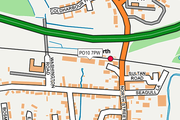
PO10 7PW is located in the Emsworth electoral ward, within the local authority district of Havant and the English Parliamentary constituency of Havant. The Sub Integrated Care Board (ICB) Location is NHS Hampshire and Isle of Wight ICB - D9Y0V and the police force is Hampshire. This postcode has been in use since January 1995.


GetTheData
Source: OS OpenMap – Local (Ordnance Survey)
Source: OS VectorMap District (Ordnance Survey)
Licence: Open Government Licence (requires attribution)
| Easting | 474765 |
| Northing | 106314 |
| Latitude | 50.851512 |
| Longitude | -0.939269 |
GetTheData
Source: Open Postcode Geo
Licence: Open Government Licence
| Country | England |
| Postcode District | PO10 |
➜ See where PO10 is on a map ➜ Where is Emsworth? | |
GetTheData
Source: Land Registry Price Paid Data
Licence: Open Government Licence
Elevation or altitude of PO10 7PW as distance above sea level:
| Metres | Feet | |
|---|---|---|
| Elevation | 40m | 131ft |
Elevation is measured from the approximate centre of the postcode, to the nearest point on an OS contour line from OS Terrain 50, which has contour spacing of ten vertical metres.
➜ How high above sea level am I? Find the elevation of your current position using your device's GPS.
GetTheData
Source: Open Postcode Elevation
Licence: Open Government Licence
| Ward | Emsworth |
| Constituency | Havant |
GetTheData
Source: ONS Postcode Database
Licence: Open Government Licence
| North Street (Victoria Road) | Emsworth | 111m |
| North Street (Victoria Road) | Emsworth | 123m |
| Victoria Road (North Street) | Emsworth | 130m |
| Victoria Road (North Street) | Emsworth | 135m |
| Bridge Road (Victoria Road) | Emsworth | 137m |
| Emsworth Station | 0.1km |
| Warblington Station | 2km |
| Southbourne Station | 2.2km |
GetTheData
Source: NaPTAN
Licence: Open Government Licence
GetTheData
Source: ONS Postcode Database
Licence: Open Government Licence


➜ Get more ratings from the Food Standards Agency
GetTheData
Source: Food Standards Agency
Licence: FSA terms & conditions
| Last Collection | |||
|---|---|---|---|
| Location | Mon-Fri | Sat | Distance |
| Victoria Road | 18:00 | 11:30 | 116m |
| Emsworth Delivery Office | 18:30 | 12:30 | 304m |
| Emsworth Delivery Office | 18:30 | 12:30 | 306m |
GetTheData
Source: Dracos
Licence: Creative Commons Attribution-ShareAlike
The below table lists the International Territorial Level (ITL) codes (formerly Nomenclature of Territorial Units for Statistics (NUTS) codes) and Local Administrative Units (LAU) codes for PO10 7PW:
| ITL 1 Code | Name |
|---|---|
| TLJ | South East (England) |
| ITL 2 Code | Name |
| TLJ3 | Hampshire and Isle of Wight |
| ITL 3 Code | Name |
| TLJ35 | South Hampshire |
| LAU 1 Code | Name |
| E07000090 | Havant |
GetTheData
Source: ONS Postcode Directory
Licence: Open Government Licence
The below table lists the Census Output Area (OA), Lower Layer Super Output Area (LSOA), and Middle Layer Super Output Area (MSOA) for PO10 7PW:
| Code | Name | |
|---|---|---|
| OA | E00116505 | |
| LSOA | E01022929 | Havant 013F |
| MSOA | E02004774 | Havant 013 |
GetTheData
Source: ONS Postcode Directory
Licence: Open Government Licence
| PO10 7NH | Victoria Road | 88m |
| PO10 7PN | North Street | 98m |
| PO10 7PH | North Street | 127m |
| PO10 7NN | Washington Road | 135m |
| PO10 7PQ | North Street | 145m |
| PO10 7PR | New Brighton Road | 169m |
| PO10 7BB | North Street | 171m |
| PO10 7PP | Sultan Road | 178m |
| PO10 7DT | Bridge Road | 183m |
| PO10 7PL | North Street | 187m |
GetTheData
Source: Open Postcode Geo; Land Registry Price Paid Data
Licence: Open Government Licence