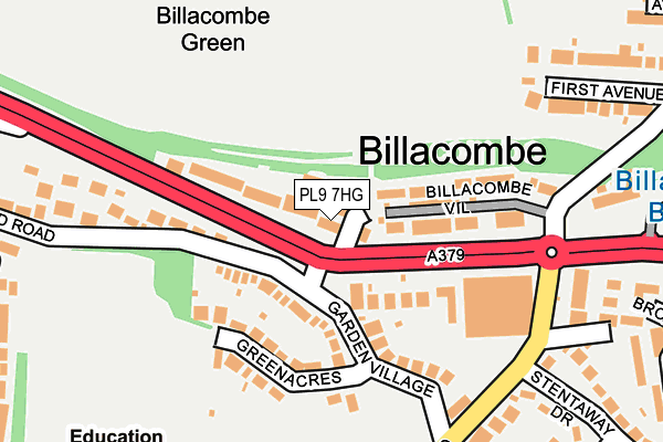
PL9 7HG lies on Billacombe Road in Plymouth. PL9 7HG is located in the Plymstock Radford electoral ward, within the unitary authority of Plymouth and the English Parliamentary constituency of South West Devon. The Sub Integrated Care Board (ICB) Location is NHS Devon ICB - 15N and the police force is Devon & Cornwall. This postcode has been in use since January 1980.


GetTheData
Source: OS OpenMap – Local (Ordnance Survey)
Source: OS VectorMap District (Ordnance Survey)
Licence: Open Government Licence (requires attribution)
| Easting | 251736 |
| Northing | 53825 |
| Latitude | 50.365601 |
| Longitude | -4.086016 |
GetTheData
Source: Open Postcode Geo
Licence: Open Government Licence
| Street | Billacombe Road |
| Town/City | Plymouth |
| Country | England |
| Postcode District | PL9 |
➜ See where PL9 is on a map ➜ Where is Plymouth? | |
GetTheData
Source: Land Registry Price Paid Data
Licence: Open Government Licence
Elevation or altitude of PL9 7HG as distance above sea level:
| Metres | Feet | |
|---|---|---|
| Elevation | 20m | 66ft |
Elevation is measured from the approximate centre of the postcode, to the nearest point on an OS contour line from OS Terrain 50, which has contour spacing of ten vertical metres.
➜ How high above sea level am I? Find the elevation of your current position using your device's GPS.
GetTheData
Source: Open Postcode Elevation
Licence: Open Government Licence
| Ward | Plymstock Radford |
| Constituency | South West Devon |
GetTheData
Source: ONS Postcode Database
Licence: Open Government Licence
| Pleasure Hill (Billacombe Road) | Billacombe | 49m |
| Boringdon Terrace | Pomphlett | 59m |
| Stentaway Road | Billacombe | 205m |
| Broadland Lane (Stentaway Road) | Plymstock | 222m |
| Stentaway Road (Elburton Road) | Billacombe | 247m |
| Plymouth Station | 4.3km |
GetTheData
Source: NaPTAN
Licence: Open Government Licence
| Percentage of properties with Next Generation Access | 100.0% |
| Percentage of properties with Superfast Broadband | 100.0% |
| Percentage of properties with Ultrafast Broadband | 100.0% |
| Percentage of properties with Full Fibre Broadband | 0.0% |
Superfast Broadband is between 30Mbps and 300Mbps
Ultrafast Broadband is > 300Mbps
| Percentage of properties unable to receive 2Mbps | 0.0% |
| Percentage of properties unable to receive 5Mbps | 0.0% |
| Percentage of properties unable to receive 10Mbps | 0.0% |
| Percentage of properties unable to receive 30Mbps | 0.0% |
GetTheData
Source: Ofcom
Licence: Ofcom Terms of Use (requires attribution)
GetTheData
Source: ONS Postcode Database
Licence: Open Government Licence

➜ Get more ratings from the Food Standards Agency
GetTheData
Source: Food Standards Agency
Licence: FSA terms & conditions
| Last Collection | |||
|---|---|---|---|
| Location | Mon-Fri | Sat | Distance |
| Greenacres | 17:00 | 13:00 | 78m |
| Plymstock Post Office | 17:30 | 12:00 | 688m |
| Stanborough Road | 17:00 | 12:45 | 724m |
GetTheData
Source: Dracos
Licence: Creative Commons Attribution-ShareAlike
The below table lists the International Territorial Level (ITL) codes (formerly Nomenclature of Territorial Units for Statistics (NUTS) codes) and Local Administrative Units (LAU) codes for PL9 7HG:
| ITL 1 Code | Name |
|---|---|
| TLK | South West (England) |
| ITL 2 Code | Name |
| TLK4 | Devon |
| ITL 3 Code | Name |
| TLK41 | Plymouth |
| LAU 1 Code | Name |
| E06000026 | Plymouth |
GetTheData
Source: ONS Postcode Directory
Licence: Open Government Licence
The below table lists the Census Output Area (OA), Lower Layer Super Output Area (LSOA), and Middle Layer Super Output Area (MSOA) for PL9 7HG:
| Code | Name | |
|---|---|---|
| OA | E00076449 | |
| LSOA | E01015135 | Plymouth 031A |
| MSOA | E02003152 | Plymouth 031 |
GetTheData
Source: ONS Postcode Directory
Licence: Open Government Licence
| PL9 7HQ | Hillside Crescent | 15m |
| PL9 7HD | Billacombe Road | 31m |
| PL9 7EL | Billacombe Road | 86m |
| PL9 7HB | Billacombe Road | 89m |
| PL9 8AL | Billacombe Villas | 106m |
| PL9 7EW | Greenacres | 129m |
| PL9 7EN | Garden Village | 144m |
| PL9 8LU | Wixenford Court | 193m |
| PL9 7EH | Stentaway Road | 202m |
| PL9 7EJ | Stentaway Road | 233m |
GetTheData
Source: Open Postcode Geo; Land Registry Price Paid Data
Licence: Open Government Licence