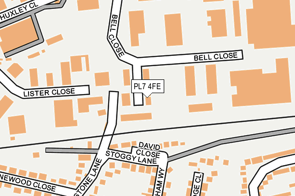
PL7 4FE is located in the Plympton St Mary electoral ward, within the unitary authority of Plymouth and the English Parliamentary constituency of South West Devon. The Sub Integrated Care Board (ICB) Location is NHS Devon ICB - 15N and the police force is Devon & Cornwall. This postcode has been in use since January 2014.


GetTheData
Source: OS OpenMap – Local (Ordnance Survey)
Source: OS VectorMap District (Ordnance Survey)
Licence: Open Government Licence (requires attribution)
| Easting | 254918 |
| Northing | 56870 |
| Latitude | 50.393762 |
| Longitude | -4.042482 |
GetTheData
Source: Open Postcode Geo
Licence: Open Government Licence
| Country | England |
| Postcode District | PL7 |
➜ See where PL7 is on a map ➜ Where is Plymouth? | |
GetTheData
Source: Land Registry Price Paid Data
Licence: Open Government Licence
Elevation or altitude of PL7 4FE as distance above sea level:
| Metres | Feet | |
|---|---|---|
| Elevation | 30m | 98ft |
Elevation is measured from the approximate centre of the postcode, to the nearest point on an OS contour line from OS Terrain 50, which has contour spacing of ten vertical metres.
➜ How high above sea level am I? Find the elevation of your current position using your device's GPS.
GetTheData
Source: Open Postcode Elevation
Licence: Open Government Licence
| Ward | Plympton St Mary |
| Constituency | South West Devon |
GetTheData
Source: ONS Postcode Database
Licence: Open Government Licence
| Bell Close | Plympton | 72m |
| Bell Close North | Newnham | 309m |
| Wallpark Close (Newnham Road) | Woodford | 333m |
| Wallpark Close (Newnham Road) | Woodford | 340m |
| Parkstone Lane | Plympton | 350m |
GetTheData
Source: NaPTAN
Licence: Open Government Licence
| Median download speed | 31.2Mbps |
| Average download speed | 31.9Mbps |
| Maximum download speed | 44.85Mbps |
| Median upload speed | 6.6Mbps |
| Average upload speed | 6.3Mbps |
| Maximum upload speed | 10.00Mbps |
GetTheData
Source: Ofcom
Licence: Ofcom Terms of Use (requires attribution)
GetTheData
Source: ONS Postcode Database
Licence: Open Government Licence


➜ Get more ratings from the Food Standards Agency
GetTheData
Source: Food Standards Agency
Licence: FSA terms & conditions
| Last Collection | |||
|---|---|---|---|
| Location | Mon-Fri | Sat | Distance |
| Westfield | 17:15 | 10:45 | 308m |
| Hemerdon | 16:30 | 07:10 | 593m |
| Longbridge Road | 19:00 | 3,689m | |
GetTheData
Source: Dracos
Licence: Creative Commons Attribution-ShareAlike
The below table lists the International Territorial Level (ITL) codes (formerly Nomenclature of Territorial Units for Statistics (NUTS) codes) and Local Administrative Units (LAU) codes for PL7 4FE:
| ITL 1 Code | Name |
|---|---|
| TLK | South West (England) |
| ITL 2 Code | Name |
| TLK4 | Devon |
| ITL 3 Code | Name |
| TLK41 | Plymouth |
| LAU 1 Code | Name |
| E06000026 | Plymouth |
GetTheData
Source: ONS Postcode Directory
Licence: Open Government Licence
The below table lists the Census Output Area (OA), Lower Layer Super Output Area (LSOA), and Middle Layer Super Output Area (MSOA) for PL7 4FE:
| Code | Name | |
|---|---|---|
| OA | E00076395 | |
| LSOA | E01015124 | Plymouth 015D |
| MSOA | E02003136 | Plymouth 015 |
GetTheData
Source: ONS Postcode Directory
Licence: Open Government Licence
| PL7 2BQ | David Close | 99m |
| PL7 2DL | Stoggy Lane | 146m |
| PL7 2DN | Stoggy Lane | 181m |
| PL7 4BA | Lister Close | 182m |
| PL7 2DJ | Newnham Way | 202m |
| PL7 2DF | Parkstone Lane | 217m |
| PL7 2DH | Torridge Close | 233m |
| PL7 2DG | Torridge Road | 253m |
| PL7 2DW | Pinewood Close | 294m |
| PL7 2DQ | Torridge Road | 298m |
GetTheData
Source: Open Postcode Geo; Land Registry Price Paid Data
Licence: Open Government Licence