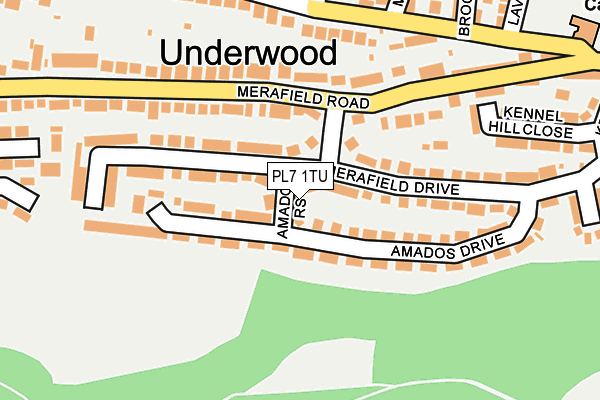
PL7 1TU lies on Amados Rise in Plymouth. PL7 1TU is located in the Plympton Erle electoral ward, within the unitary authority of Plymouth and the English Parliamentary constituency of South West Devon. The Sub Integrated Care Board (ICB) Location is NHS Devon ICB - 15N and the police force is Devon & Cornwall. This postcode has been in use since June 1996.


GetTheData
Source: OS OpenMap – Local (Ordnance Survey)
Source: OS VectorMap District (Ordnance Survey)
Licence: Open Government Licence (requires attribution)
| Easting | 253254 |
| Northing | 55871 |
| Latitude | 50.384370 |
| Longitude | -4.065486 |
GetTheData
Source: Open Postcode Geo
Licence: Open Government Licence
| Street | Amados Rise |
| Town/City | Plymouth |
| Country | England |
| Postcode District | PL7 |
➜ See where PL7 is on a map ➜ Where is Plymouth? | |
GetTheData
Source: Land Registry Price Paid Data
Licence: Open Government Licence
Elevation or altitude of PL7 1TU as distance above sea level:
| Metres | Feet | |
|---|---|---|
| Elevation | 40m | 131ft |
Elevation is measured from the approximate centre of the postcode, to the nearest point on an OS contour line from OS Terrain 50, which has contour spacing of ten vertical metres.
➜ How high above sea level am I? Find the elevation of your current position using your device's GPS.
GetTheData
Source: Open Postcode Elevation
Licence: Open Government Licence
| Ward | Plympton Erle |
| Constituency | South West Devon |
GetTheData
Source: ONS Postcode Database
Licence: Open Government Licence
| Merafield Rise | Underwood | 61m |
| Merafield Rise | Underwood | 87m |
| Amados Drive | Underwood | 123m |
| Merafield Drive | Underwood | 196m |
| Merafield Road | Underwood | 233m |
GetTheData
Source: NaPTAN
Licence: Open Government Licence
| Percentage of properties with Next Generation Access | 100.0% |
| Percentage of properties with Superfast Broadband | 100.0% |
| Percentage of properties with Ultrafast Broadband | 100.0% |
| Percentage of properties with Full Fibre Broadband | 0.0% |
Superfast Broadband is between 30Mbps and 300Mbps
Ultrafast Broadband is > 300Mbps
| Percentage of properties unable to receive 2Mbps | 0.0% |
| Percentage of properties unable to receive 5Mbps | 0.0% |
| Percentage of properties unable to receive 10Mbps | 0.0% |
| Percentage of properties unable to receive 30Mbps | 0.0% |
GetTheData
Source: Ofcom
Licence: Ofcom Terms of Use (requires attribution)
GetTheData
Source: ONS Postcode Database
Licence: Open Government Licence


➜ Get more ratings from the Food Standards Agency
GetTheData
Source: Food Standards Agency
Licence: FSA terms & conditions
| Last Collection | |||
|---|---|---|---|
| Location | Mon-Fri | Sat | Distance |
| Westfield | 17:15 | 10:45 | 2,074m |
| Pike Road Post Office | 17:00 | 12:00 | 2,360m |
| Fairview Avenue | 16:45 | 12:00 | 2,478m |
GetTheData
Source: Dracos
Licence: Creative Commons Attribution-ShareAlike
The below table lists the International Territorial Level (ITL) codes (formerly Nomenclature of Territorial Units for Statistics (NUTS) codes) and Local Administrative Units (LAU) codes for PL7 1TU:
| ITL 1 Code | Name |
|---|---|
| TLK | South West (England) |
| ITL 2 Code | Name |
| TLK4 | Devon |
| ITL 3 Code | Name |
| TLK41 | Plymouth |
| LAU 1 Code | Name |
| E06000026 | Plymouth |
GetTheData
Source: ONS Postcode Directory
Licence: Open Government Licence
The below table lists the Census Output Area (OA), Lower Layer Super Output Area (LSOA), and Middle Layer Super Output Area (MSOA) for PL7 1TU:
| Code | Name | |
|---|---|---|
| OA | E00076357 | |
| LSOA | E01015112 | Plymouth 019A |
| MSOA | E02003140 | Plymouth 019 |
GetTheData
Source: ONS Postcode Directory
Licence: Open Government Licence
| PL7 1TT | Amados Drive | 95m |
| PL7 1TS | Amados Drive | 116m |
| PL7 1TP | Merafield Drive | 124m |
| PL7 1TR | Merafield Drive | 130m |
| PL7 1SH | Merafield Road | 142m |
| PL7 1QU | Underlane | 173m |
| PL7 1TL | Merafield Road | 211m |
| PL7 1QX | Underlane | 213m |
| PL7 1QT | Underlane | 235m |
| PL7 1QE | Kennel Hill Close | 239m |
GetTheData
Source: Open Postcode Geo; Land Registry Price Paid Data
Licence: Open Government Licence