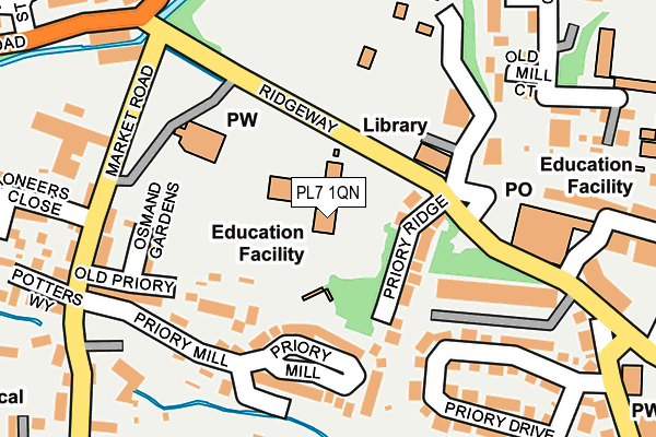
PL7 1QN is located in the Plympton Erle electoral ward, within the unitary authority of Plymouth and the English Parliamentary constituency of South West Devon. The Sub Integrated Care Board (ICB) Location is NHS Devon ICB - 15N and the police force is Devon & Cornwall. This postcode has been in use since June 1996.


GetTheData
Source: OS OpenMap – Local (Ordnance Survey)
Source: OS VectorMap District (Ordnance Survey)
Licence: Open Government Licence (requires attribution)
| Easting | 253881 |
| Northing | 56250 |
| Latitude | 50.387933 |
| Longitude | -4.056820 |
GetTheData
Source: Open Postcode Geo
Licence: Open Government Licence
| Country | England |
| Postcode District | PL7 |
➜ See where PL7 is on a map ➜ Where is Plymouth? | |
GetTheData
Source: Land Registry Price Paid Data
Licence: Open Government Licence
Elevation or altitude of PL7 1QN as distance above sea level:
| Metres | Feet | |
|---|---|---|
| Elevation | 20m | 66ft |
Elevation is measured from the approximate centre of the postcode, to the nearest point on an OS contour line from OS Terrain 50, which has contour spacing of ten vertical metres.
➜ How high above sea level am I? Find the elevation of your current position using your device's GPS.
GetTheData
Source: Open Postcode Elevation
Licence: Open Government Licence
| Ward | Plympton Erle |
| Constituency | South West Devon |
GetTheData
Source: ONS Postcode Database
Licence: Open Government Licence
| Old Priory Junior School (Ridgeway) | Underwood | 67m |
| Priory Junior School (Mudge Way) | Plympton | 103m |
| St Mary's Bridge | Plympton | 176m |
| St Mary's Church (Ridgeway) | Plympton | 215m |
| Ridgeway West (Ridgeway) | Plympton | 243m |
GetTheData
Source: NaPTAN
Licence: Open Government Licence
GetTheData
Source: ONS Postcode Database
Licence: Open Government Licence


➜ Get more ratings from the Food Standards Agency
GetTheData
Source: Food Standards Agency
Licence: FSA terms & conditions
| Last Collection | |||
|---|---|---|---|
| Location | Mon-Fri | Sat | Distance |
| Westfield | 17:15 | 10:45 | 1,351m |
| Hemerdon | 16:30 | 07:10 | 1,794m |
| Pike Road Post Office | 17:00 | 12:00 | 2,941m |
GetTheData
Source: Dracos
Licence: Creative Commons Attribution-ShareAlike
The below table lists the International Territorial Level (ITL) codes (formerly Nomenclature of Territorial Units for Statistics (NUTS) codes) and Local Administrative Units (LAU) codes for PL7 1QN:
| ITL 1 Code | Name |
|---|---|
| TLK | South West (England) |
| ITL 2 Code | Name |
| TLK4 | Devon |
| ITL 3 Code | Name |
| TLK41 | Plymouth |
| LAU 1 Code | Name |
| E06000026 | Plymouth |
GetTheData
Source: ONS Postcode Directory
Licence: Open Government Licence
The below table lists the Census Output Area (OA), Lower Layer Super Output Area (LSOA), and Middle Layer Super Output Area (MSOA) for PL7 1QN:
| Code | Name | |
|---|---|---|
| OA | E00076347 | |
| LSOA | E01015114 | Plymouth 019C |
| MSOA | E02003140 | Plymouth 019 |
GetTheData
Source: ONS Postcode Directory
Licence: Open Government Licence
| PL7 1WS | Priory Ridge | 93m |
| PL7 1QS | Old Priory | 140m |
| PL7 1WR | Priory Mill | 157m |
| PL7 1AA | Osmand Gardens | 164m |
| PL7 1PT | Saltram Terrace | 166m |
| PL7 2AJ | Old Mill Court | 200m |
| PL7 1PU | Priory Drive | 205m |
| PL7 1QW | Market Road | 225m |
| PL7 2AU | Station Road | 233m |
| PL7 1PX | Priory Drive | 249m |
GetTheData
Source: Open Postcode Geo; Land Registry Price Paid Data
Licence: Open Government Licence