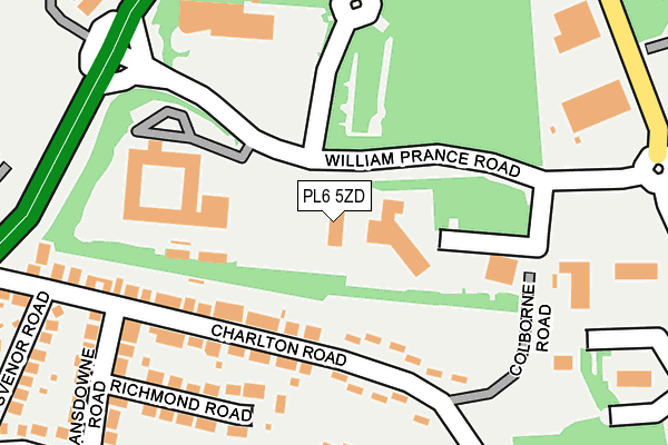
PL6 5ZD is located in the Moor View electoral ward, within the unitary authority of Plymouth and the English Parliamentary constituency of Plymouth, Moor View. The Sub Integrated Care Board (ICB) Location is NHS Devon ICB - 15N and the police force is Devon & Cornwall. This postcode has been in use since February 2006.


GetTheData
Source: OS OpenMap – Local (Ordnance Survey)
Source: OS VectorMap District (Ordnance Survey)
Licence: Open Government Licence (requires attribution)
| Easting | 249196 |
| Northing | 59228 |
| Latitude | 50.413499 |
| Longitude | -4.123901 |
GetTheData
Source: Open Postcode Geo
Licence: Open Government Licence
| Country | England |
| Postcode District | PL6 |
➜ See where PL6 is on a map ➜ Where is Plymouth? | |
GetTheData
Source: Land Registry Price Paid Data
Licence: Open Government Licence
Elevation or altitude of PL6 5ZD as distance above sea level:
| Metres | Feet | |
|---|---|---|
| Elevation | 120m | 394ft |
Elevation is measured from the approximate centre of the postcode, to the nearest point on an OS contour line from OS Terrain 50, which has contour spacing of ten vertical metres.
➜ How high above sea level am I? Find the elevation of your current position using your device's GPS.
GetTheData
Source: Open Postcode Elevation
Licence: Open Government Licence
| Ward | Moor View |
| Constituency | Plymouth, Moor View |
GetTheData
Source: ONS Postcode Database
Licence: Open Government Licence
| Land Registry | Derriford | 97m |
| Future Inns | Derriford | 116m |
| Peninsular Radiology | Derriford | 144m |
| Tavistock Road | Crownhill | 203m |
| William Prance Road | Crownhill | 228m |
| Plymouth Station | 4.2km |
| St Budeaux Ferry Road Station | 4.7km |
| St Budeaux Victoria Road Station | 4.7km |
GetTheData
Source: NaPTAN
Licence: Open Government Licence
GetTheData
Source: ONS Postcode Database
Licence: Open Government Licence


➜ Get more ratings from the Food Standards Agency
GetTheData
Source: Food Standards Agency
Licence: FSA terms & conditions
| Last Collection | |||
|---|---|---|---|
| Location | Mon-Fri | Sat | Distance |
| Crownhill Post Office | 18:15 | 12:00 | 948m |
| Penrith Gardens | 17:15 | 12:30 | 1,069m |
| Langdale Gardens | 17:00 | 12:00 | 1,424m |
GetTheData
Source: Dracos
Licence: Creative Commons Attribution-ShareAlike
The below table lists the International Territorial Level (ITL) codes (formerly Nomenclature of Territorial Units for Statistics (NUTS) codes) and Local Administrative Units (LAU) codes for PL6 5ZD:
| ITL 1 Code | Name |
|---|---|
| TLK | South West (England) |
| ITL 2 Code | Name |
| TLK4 | Devon |
| ITL 3 Code | Name |
| TLK41 | Plymouth |
| LAU 1 Code | Name |
| E06000026 | Plymouth |
GetTheData
Source: ONS Postcode Directory
Licence: Open Government Licence
The below table lists the Census Output Area (OA), Lower Layer Super Output Area (LSOA), and Middle Layer Super Output Area (MSOA) for PL6 5ZD:
| Code | Name | |
|---|---|---|
| OA | E00172072 | |
| LSOA | E01015092 | Plymouth 005C |
| MSOA | E02003126 | Plymouth 005 |
GetTheData
Source: ONS Postcode Directory
Licence: Open Government Licence
| PL6 5EG | Charlton Road | 223m |
| PL6 5EE | Richmond Road | 294m |
| PL6 5EF | Charlton Road | 297m |
| PL6 5ED | Lansdowne Road | 352m |
| PL6 5XN | Brest Road | 361m |
| PL6 5EB | Smallack Drive | 384m |
| PL6 5EH | Grosvenor Road | 386m |
| PL6 5EJ | Tavistock Road | 391m |
| PL6 5FB | Smallack Drive | 396m |
| PL6 5EN | Smallack Close | 486m |
GetTheData
Source: Open Postcode Geo; Land Registry Price Paid Data
Licence: Open Government Licence