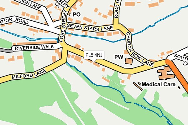
PL5 4NJ lies on Tamerton Foliot Road in Plymouth. PL5 4NJ is located in the Southway electoral ward, within the unitary authority of Plymouth and the English Parliamentary constituency of Plymouth, Moor View. The Sub Integrated Care Board (ICB) Location is NHS Devon ICB - 15N and the police force is Devon & Cornwall. This postcode has been in use since January 1980.


GetTheData
Source: OS OpenMap – Local (Ordnance Survey)
Source: OS VectorMap District (Ordnance Survey)
Licence: Open Government Licence (requires attribution)
| Easting | 247043 |
| Northing | 60821 |
| Latitude | 50.427258 |
| Longitude | -4.154832 |
GetTheData
Source: Open Postcode Geo
Licence: Open Government Licence
| Street | Tamerton Foliot Road |
| Town/City | Plymouth |
| Country | England |
| Postcode District | PL5 |
➜ See where PL5 is on a map ➜ Where is Plymouth? | |
GetTheData
Source: Land Registry Price Paid Data
Licence: Open Government Licence
Elevation or altitude of PL5 4NJ as distance above sea level:
| Metres | Feet | |
|---|---|---|
| Elevation | 10m | 33ft |
Elevation is measured from the approximate centre of the postcode, to the nearest point on an OS contour line from OS Terrain 50, which has contour spacing of ten vertical metres.
➜ How high above sea level am I? Find the elevation of your current position using your device's GPS.
GetTheData
Source: Open Postcode Elevation
Licence: Open Government Licence
| Ward | Southway |
| Constituency | Plymouth, Moor View |
GetTheData
Source: ONS Postcode Database
Licence: Open Government Licence
WADLANDS, TAMERTON FOLIOT ROAD, PLYMOUTH, PL5 4NJ 2013 12 SEP £500,000 |
GetTheData
Source: HM Land Registry Price Paid Data
Licence: Contains HM Land Registry data © Crown copyright and database right 2025. This data is licensed under the Open Government Licence v3.0.
| Station Road (Fore Street) | Tamerton Foliot | 143m |
| Queens Arms (Seven Stars Lane) | Tamerton Foliot | 146m |
| Church Row Lane (Tamerton Foliot Road) | Tamerton Foliot | 205m |
| Horsham Lane (Fore Street) | Tamerton Foliot | 235m |
| The Chapel (Fore Street) | Tamerton Foliot | 246m |
| Bere Ferrers Station | 3.3km |
| St Budeaux Victoria Road Station | 3.6km |
| St Budeaux Ferry Road Station | 3.7km |
GetTheData
Source: NaPTAN
Licence: Open Government Licence
| Percentage of properties with Next Generation Access | 100.0% |
| Percentage of properties with Superfast Broadband | 100.0% |
| Percentage of properties with Ultrafast Broadband | 0.0% |
| Percentage of properties with Full Fibre Broadband | 0.0% |
Superfast Broadband is between 30Mbps and 300Mbps
Ultrafast Broadband is > 300Mbps
| Percentage of properties unable to receive 2Mbps | 0.0% |
| Percentage of properties unable to receive 5Mbps | 0.0% |
| Percentage of properties unable to receive 10Mbps | 0.0% |
| Percentage of properties unable to receive 30Mbps | 0.0% |
GetTheData
Source: Ofcom
Licence: Ofcom Terms of Use (requires attribution)
GetTheData
Source: ONS Postcode Database
Licence: Open Government Licence


➜ Get more ratings from the Food Standards Agency
GetTheData
Source: Food Standards Agency
Licence: FSA terms & conditions
| Last Collection | |||
|---|---|---|---|
| Location | Mon-Fri | Sat | Distance |
| Lakeside Drive | 17:00 | 12:00 | 1,102m |
| Crownhill Post Office | 18:15 | 12:00 | 2,719m |
| Beverston Way | 17:30 | 12:30 | 3,111m |
GetTheData
Source: Dracos
Licence: Creative Commons Attribution-ShareAlike
The below table lists the International Territorial Level (ITL) codes (formerly Nomenclature of Territorial Units for Statistics (NUTS) codes) and Local Administrative Units (LAU) codes for PL5 4NJ:
| ITL 1 Code | Name |
|---|---|
| TLK | South West (England) |
| ITL 2 Code | Name |
| TLK4 | Devon |
| ITL 3 Code | Name |
| TLK41 | Plymouth |
| LAU 1 Code | Name |
| E06000026 | Plymouth |
GetTheData
Source: ONS Postcode Directory
Licence: Open Government Licence
The below table lists the Census Output Area (OA), Lower Layer Super Output Area (LSOA), and Middle Layer Super Output Area (MSOA) for PL5 4NJ:
| Code | Name | |
|---|---|---|
| OA | E00076600 | |
| LSOA | E01015163 | Plymouth 003D |
| MSOA | E02003124 | Plymouth 003 |
GetTheData
Source: ONS Postcode Directory
Licence: Open Government Licence
| PL5 4NH | Tamerton Foliot Road | 26m |
| PL5 4NG | Milford Lane | 128m |
| PL5 4NN | Seven Stars Lane | 133m |
| PL5 4NZ | Church Row Lane | 154m |
| PL5 4NB | Lambert Road | 185m |
| PL5 4NL | Tamerton Foliot Road | 187m |
| PL5 4NW | Fore Street | 189m |
| PL5 4NA | Fore Street | 204m |
| PL5 4AQ | Riverside Walk | 213m |
| PL5 4NE | Old Warleigh Lane | 223m |
GetTheData
Source: Open Postcode Geo; Land Registry Price Paid Data
Licence: Open Government Licence