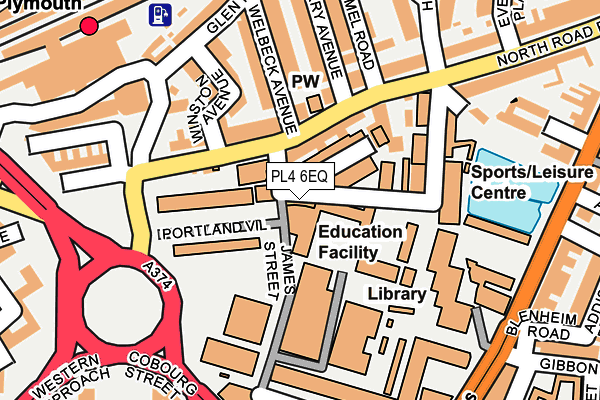
PL4 6EQ is located in the Drake electoral ward, within the unitary authority of Plymouth and the English Parliamentary constituency of Plymouth, Sutton and Devonport. The Sub Integrated Care Board (ICB) Location is NHS Devon ICB - 15N and the police force is Devon & Cornwall. This postcode has been in use since January 1980.


GetTheData
Source: OS OpenMap – Local (Ordnance Survey)
Source: OS VectorMap District (Ordnance Survey)
Licence: Open Government Licence (requires attribution)
| Easting | 247923 |
| Northing | 55141 |
| Latitude | 50.376454 |
| Longitude | -4.140122 |
GetTheData
Source: Open Postcode Geo
Licence: Open Government Licence
| Country | England |
| Postcode District | PL4 |
➜ See where PL4 is on a map ➜ Where is Plymouth? | |
GetTheData
Source: Land Registry Price Paid Data
Licence: Open Government Licence
Elevation or altitude of PL4 6EQ as distance above sea level:
| Metres | Feet | |
|---|---|---|
| Elevation | 40m | 131ft |
Elevation is measured from the approximate centre of the postcode, to the nearest point on an OS contour line from OS Terrain 50, which has contour spacing of ten vertical metres.
➜ How high above sea level am I? Find the elevation of your current position using your device's GPS.
GetTheData
Source: Open Postcode Elevation
Licence: Open Government Licence
| Ward | Drake |
| Constituency | Plymouth, Sutton And Devonport |
GetTheData
Source: ONS Postcode Database
Licence: Open Government Licence
| James Street (North Road East) | Plymouth | 73m |
| Welbeck Avenue (North Road East) | Plymouth | 78m |
| North Road East | Pennycomequick | 122m |
| North Road East | Pennycomequick | 126m |
| Sutherland Road (North Road East) | Plymouth | 207m |
| Plymouth Station | 0.3km |
| Devonport Station | 2.2km |
| Dockyard (Plymouth) Station | 2.6km |
GetTheData
Source: NaPTAN
Licence: Open Government Licence
GetTheData
Source: ONS Postcode Database
Licence: Open Government Licence


➜ Get more ratings from the Food Standards Agency
GetTheData
Source: Food Standards Agency
Licence: FSA terms & conditions
| Last Collection | |||
|---|---|---|---|
| Location | Mon-Fri | Sat | Distance |
| Bedford Terrace | 18:30 | 12:00 | 112m |
| Sherwell | 18:30 | 12:00 | 252m |
| Plymouth Station | 17:45 | 12:15 | 263m |
GetTheData
Source: Dracos
Licence: Creative Commons Attribution-ShareAlike
The below table lists the International Territorial Level (ITL) codes (formerly Nomenclature of Territorial Units for Statistics (NUTS) codes) and Local Administrative Units (LAU) codes for PL4 6EQ:
| ITL 1 Code | Name |
|---|---|
| TLK | South West (England) |
| ITL 2 Code | Name |
| TLK4 | Devon |
| ITL 3 Code | Name |
| TLK41 | Plymouth |
| LAU 1 Code | Name |
| E06000026 | Plymouth |
GetTheData
Source: ONS Postcode Directory
Licence: Open Government Licence
The below table lists the Census Output Area (OA), Lower Layer Super Output Area (LSOA), and Middle Layer Super Output Area (MSOA) for PL4 6EQ:
| Code | Name | |
|---|---|---|
| OA | E00076044 | |
| LSOA | E01015054 | Plymouth 027B |
| MSOA | E02003148 | Plymouth 027 |
GetTheData
Source: ONS Postcode Directory
Licence: Open Government Licence
| PL4 6DT | Kirkby Place | 55m |
| PL4 6AN | North Road East | 83m |
| PL4 6AW | North Road East | 87m |
| PL4 6DU | Kirkby Terrace | 89m |
| PL4 6AH | North Road East | 129m |
| PL4 6AZ | Winston Avenue | 141m |
| PL4 6DN | Endsleigh Place | 160m |
| PL4 6BG | Welbeck Avenue | 161m |
| PL4 6AL | North Road East | 170m |
| PL4 6BP | Restormel Road | 185m |
GetTheData
Source: Open Postcode Geo; Land Registry Price Paid Data
Licence: Open Government Licence