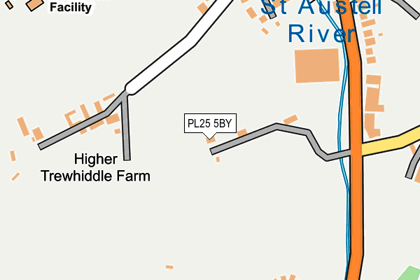
PL25 5BY lies on Rocky Park Road in St. Austell. PL25 5BY is located in the St Austell Central & Gover electoral ward, within the unitary authority of Cornwall and the English Parliamentary constituency of St Austell and Newquay. The Sub Integrated Care Board (ICB) Location is NHS Cornwall and the Isles of Scilly ICB - 11N and the police force is Devon & Cornwall. This postcode has been in use since January 1980.


GetTheData
Source: OS OpenMap – Local (Ordnance Survey)
Source: OS VectorMap District (Ordnance Survey)
Licence: Open Government Licence (requires attribution)
| Easting | 201137 |
| Northing | 51662 |
| Latitude | 50.331231 |
| Longitude | -4.795578 |
GetTheData
Source: Open Postcode Geo
Licence: Open Government Licence
| Street | Rocky Park Road |
| Town/City | St. Austell |
| Country | England |
| Postcode District | PL25 |
➜ See where PL25 is on a map ➜ Where is St Austell? | |
GetTheData
Source: Land Registry Price Paid Data
Licence: Open Government Licence
Elevation or altitude of PL25 5BY as distance above sea level:
| Metres | Feet | |
|---|---|---|
| Elevation | 40m | 131ft |
Elevation is measured from the approximate centre of the postcode, to the nearest point on an OS contour line from OS Terrain 50, which has contour spacing of ten vertical metres.
➜ How high above sea level am I? Find the elevation of your current position using your device's GPS.
GetTheData
Source: Open Postcode Elevation
Licence: Open Government Licence
| Ward | St Austell Central & Gover |
| Constituency | St Austell And Newquay |
GetTheData
Source: ONS Postcode Database
Licence: Open Government Licence
STRATH BLAYNE, ROCKY PARK ROAD, ST. AUSTELL, PL25 5BY 2004 22 OCT £160,000 |
GetTheData
Source: HM Land Registry Price Paid Data
Licence: Contains HM Land Registry data © Crown copyright and database right 2025. This data is licensed under the Open Government Licence v3.0.
| B And Q (Pentewan Road) | St Austell | 312m |
| B And Q (Pentewan Road) | St Austell | 319m |
| Penwinnick Road | St Austell | 372m |
| Penwinnick Road | St Austell | 378m |
| Moorland Road | St Austell | 463m |
| St Austell Station | 1km |
GetTheData
Source: NaPTAN
Licence: Open Government Licence
| Percentage of properties with Next Generation Access | 100.0% |
| Percentage of properties with Superfast Broadband | 100.0% |
| Percentage of properties with Ultrafast Broadband | 0.0% |
| Percentage of properties with Full Fibre Broadband | 0.0% |
Superfast Broadband is between 30Mbps and 300Mbps
Ultrafast Broadband is > 300Mbps
| Percentage of properties unable to receive 2Mbps | 0.0% |
| Percentage of properties unable to receive 5Mbps | 0.0% |
| Percentage of properties unable to receive 10Mbps | 0.0% |
| Percentage of properties unable to receive 30Mbps | 0.0% |
GetTheData
Source: Ofcom
Licence: Ofcom Terms of Use (requires attribution)
GetTheData
Source: ONS Postcode Database
Licence: Open Government Licence


➜ Get more ratings from the Food Standards Agency
GetTheData
Source: Food Standards Agency
Licence: FSA terms & conditions
| Last Collection | |||
|---|---|---|---|
| Location | Mon-Fri | Sat | Distance |
| Tregorrick | 17:45 | 07:15 | 496m |
| Tregonney Hill | 11:15 | 10:30 | 528m |
| Penwinnick Road | 17:45 | 11:45 | 621m |
GetTheData
Source: Dracos
Licence: Creative Commons Attribution-ShareAlike
The below table lists the International Territorial Level (ITL) codes (formerly Nomenclature of Territorial Units for Statistics (NUTS) codes) and Local Administrative Units (LAU) codes for PL25 5BY:
| ITL 1 Code | Name |
|---|---|
| TLK | South West (England) |
| ITL 2 Code | Name |
| TLK3 | Cornwall and Isles of Scilly |
| ITL 3 Code | Name |
| TLK30 | Cornwall and Isles of Scilly |
| LAU 1 Code | Name |
| E06000052 | Cornwall |
GetTheData
Source: ONS Postcode Directory
Licence: Open Government Licence
The below table lists the Census Output Area (OA), Lower Layer Super Output Area (LSOA), and Middle Layer Super Output Area (MSOA) for PL25 5BY:
| Code | Name | |
|---|---|---|
| OA | E00096170 | |
| LSOA | E01019033 | Cornwall 039A |
| MSOA | E02003963 | Cornwall 039 |
GetTheData
Source: ONS Postcode Directory
Licence: Open Government Licence
| PL25 5DA | Trewhiddle Road | 191m |
| PL25 5BZ | Trewhiddle Road | 216m |
| PL25 5BU | Pentewan Road | 282m |
| PL26 7AB | Pentewan Road | 383m |
| PL25 5DW | Penwinnick Road | 400m |
| PL25 4UH | Belmont Road | 466m |
| PL25 5DT | Pondhu Crescent | 468m |
| PL25 5BN | South Street | 491m |
| PL25 5DS | Penwinnick Road | 497m |
| PL25 4UU | Trelevan Close | 510m |
GetTheData
Source: Open Postcode Geo; Land Registry Price Paid Data
Licence: Open Government Licence