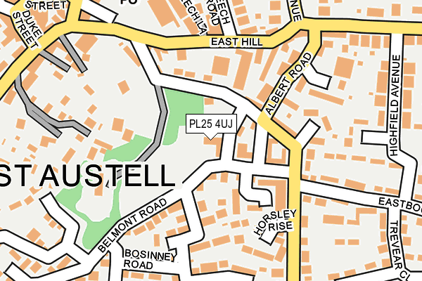
PL25 4UJ lies on Belmont Road in St Austell. PL25 4UJ is located in the St Austell Central & Gover electoral ward, within the unitary authority of Cornwall and the English Parliamentary constituency of St Austell and Newquay. The Sub Integrated Care Board (ICB) Location is NHS Cornwall and the Isles of Scilly ICB - 11N and the police force is Devon & Cornwall. This postcode has been in use since January 1980.


GetTheData
Source: OS OpenMap – Local (Ordnance Survey)
Source: OS VectorMap District (Ordnance Survey)
Licence: Open Government Licence (requires attribution)
| Easting | 201661 |
| Northing | 52224 |
| Latitude | 50.336469 |
| Longitude | -4.788477 |
GetTheData
Source: Open Postcode Geo
Licence: Open Government Licence
| Street | Belmont Road |
| Town/City | St Austell |
| Country | England |
| Postcode District | PL25 |
➜ See where PL25 is on a map ➜ Where is St Austell? | |
GetTheData
Source: Land Registry Price Paid Data
Licence: Open Government Licence
Elevation or altitude of PL25 4UJ as distance above sea level:
| Metres | Feet | |
|---|---|---|
| Elevation | 70m | 230ft |
Elevation is measured from the approximate centre of the postcode, to the nearest point on an OS contour line from OS Terrain 50, which has contour spacing of ten vertical metres.
➜ How high above sea level am I? Find the elevation of your current position using your device's GPS.
GetTheData
Source: Open Postcode Elevation
Licence: Open Government Licence
| Ward | St Austell Central & Gover |
| Constituency | St Austell And Newquay |
GetTheData
Source: ONS Postcode Database
Licence: Open Government Licence
2, BELMONT ROAD, ST. AUSTELL, PL25 4UJ 1999 12 AUG £60,000 |
GetTheData
Source: HM Land Registry Price Paid Data
Licence: Contains HM Land Registry data © Crown copyright and database right 2025. This data is licensed under the Open Government Licence v3.0.
| Kings Avenue (King's Avenue) | St Austell | 247m |
| Alexandra Road | St Austell | 265m |
| Alexandra Road | St Austell | 272m |
| South Street | St Austell | 289m |
| Duke Street | St Austell | 303m |
| St Austell Station | 0.3km |
GetTheData
Source: NaPTAN
Licence: Open Government Licence
| Percentage of properties with Next Generation Access | 15.0% |
| Percentage of properties with Superfast Broadband | 15.0% |
| Percentage of properties with Ultrafast Broadband | 15.0% |
| Percentage of properties with Full Fibre Broadband | 15.0% |
Superfast Broadband is between 30Mbps and 300Mbps
Ultrafast Broadband is > 300Mbps
| Median download speed | 23.1Mbps |
| Average download speed | 22.0Mbps |
| Maximum download speed | 23.96Mbps |
| Median upload speed | 1.2Mbps |
| Average upload speed | 1.2Mbps |
| Maximum upload speed | 1.29Mbps |
| Percentage of properties unable to receive 2Mbps | 0.0% |
| Percentage of properties unable to receive 5Mbps | 0.0% |
| Percentage of properties unable to receive 10Mbps | 0.0% |
| Percentage of properties unable to receive 30Mbps | 85.0% |
GetTheData
Source: Ofcom
Licence: Ofcom Terms of Use (requires attribution)
Estimated total energy consumption in PL25 4UJ by fuel type, 2015.
| Consumption (kWh) | 143,022 |
|---|---|
| Meter count | 18 |
| Mean (kWh/meter) | 7,946 |
| Median (kWh/meter) | 3,865 |
| Consumption (kWh) | 61,535 |
|---|---|
| Meter count | 19 |
| Mean (kWh/meter) | 3,239 |
| Median (kWh/meter) | 3,032 |
GetTheData
Source: Postcode level gas estimates: 2015 (experimental)
Source: Postcode level electricity estimates: 2015 (experimental)
Licence: Open Government Licence
GetTheData
Source: ONS Postcode Database
Licence: Open Government Licence


➜ Get more ratings from the Food Standards Agency
GetTheData
Source: Food Standards Agency
Licence: FSA terms & conditions
| Last Collection | |||
|---|---|---|---|
| Location | Mon-Fri | Sat | Distance |
| Railway Station | 17:30 | 09:30 | 332m |
| Fore Street | 16:00 | 12:00 | 384m |
| Tregonney Hill | 11:15 | 10:30 | 391m |
GetTheData
Source: Dracos
Licence: Creative Commons Attribution-ShareAlike
The below table lists the International Territorial Level (ITL) codes (formerly Nomenclature of Territorial Units for Statistics (NUTS) codes) and Local Administrative Units (LAU) codes for PL25 4UJ:
| ITL 1 Code | Name |
|---|---|
| TLK | South West (England) |
| ITL 2 Code | Name |
| TLK3 | Cornwall and Isles of Scilly |
| ITL 3 Code | Name |
| TLK30 | Cornwall and Isles of Scilly |
| LAU 1 Code | Name |
| E06000052 | Cornwall |
GetTheData
Source: ONS Postcode Directory
Licence: Open Government Licence
The below table lists the Census Output Area (OA), Lower Layer Super Output Area (LSOA), and Middle Layer Super Output Area (MSOA) for PL25 4UJ:
| Code | Name | |
|---|---|---|
| OA | E00096233 | |
| LSOA | E01019041 | Cornwall 039B |
| MSOA | E02003963 | Cornwall 039 |
GetTheData
Source: ONS Postcode Directory
Licence: Open Government Licence
| PL25 4UA | Belmont Road | 59m |
| PL25 4SX | Eastbourne Road | 83m |
| PL25 4UQ | Belmont Road | 101m |
| PL25 4SU | Eastbourne Road | 119m |
| PL25 4SZ | Eastbourne Road | 122m |
| PL25 4UG | Chisholme Close | 123m |
| PL25 4TR | East Hill | 143m |
| PL25 4TQ | Jadeana Court | 145m |
| PL25 4UP | Horsley Rise | 150m |
| PL25 4TZ | Albert Road | 152m |
GetTheData
Source: Open Postcode Geo; Land Registry Price Paid Data
Licence: Open Government Licence