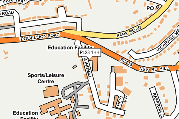
PL23 1HH is located in the Fowey, Tywardreath & Par electoral ward, within the unitary authority of Cornwall and the English Parliamentary constituency of St Austell and Newquay. The Sub Integrated Care Board (ICB) Location is NHS Cornwall and the Isles of Scilly ICB - 11N and the police force is Devon & Cornwall. This postcode has been in use since February 1990.


GetTheData
Source: OS OpenMap – Local (Ordnance Survey)
Source: OS VectorMap District (Ordnance Survey)
Licence: Open Government Licence (requires attribution)
| Easting | 212046 |
| Northing | 51851 |
| Latitude | 50.336525 |
| Longitude | -4.642527 |
GetTheData
Source: Open Postcode Geo
Licence: Open Government Licence
| Country | England |
| Postcode District | PL23 |
➜ See where PL23 is on a map ➜ Where is Fowey? | |
GetTheData
Source: Land Registry Price Paid Data
Licence: Open Government Licence
Elevation or altitude of PL23 1HH as distance above sea level:
| Metres | Feet | |
|---|---|---|
| Elevation | 70m | 230ft |
Elevation is measured from the approximate centre of the postcode, to the nearest point on an OS contour line from OS Terrain 50, which has contour spacing of ten vertical metres.
➜ How high above sea level am I? Find the elevation of your current position using your device's GPS.
GetTheData
Source: Open Postcode Elevation
Licence: Open Government Licence
| Ward | Fowey, Tywardreath & Par |
| Constituency | St Austell And Newquay |
GetTheData
Source: ONS Postcode Database
Licence: Open Government Licence
| Windmill (Polvillion Road) | Fowey | 98m |
| Community College (Polvillion Road) | Fowey | 129m |
| Community College (Polvillion Road) | Fowey | 137m |
| Fowey School (Windmill) | Fowey | 157m |
| Windmill Industrial Estate (Windmill) | Fowey | 178m |
| Par Station | 4.9km |
GetTheData
Source: NaPTAN
Licence: Open Government Licence
GetTheData
Source: ONS Postcode Database
Licence: Open Government Licence


➜ Get more ratings from the Food Standards Agency
GetTheData
Source: Food Standards Agency
Licence: FSA terms & conditions
| Last Collection | |||
|---|---|---|---|
| Location | Mon-Fri | Sat | Distance |
| Park Road Post Office | 17:15 | 12:00 | 287m |
| Polvillion Road | 16:45 | 12:00 | 328m |
| Browns Hill | 16:45 | 11:45 | 387m |
GetTheData
Source: Dracos
Licence: Creative Commons Attribution-ShareAlike
The below table lists the International Territorial Level (ITL) codes (formerly Nomenclature of Territorial Units for Statistics (NUTS) codes) and Local Administrative Units (LAU) codes for PL23 1HH:
| ITL 1 Code | Name |
|---|---|
| TLK | South West (England) |
| ITL 2 Code | Name |
| TLK3 | Cornwall and Isles of Scilly |
| ITL 3 Code | Name |
| TLK30 | Cornwall and Isles of Scilly |
| LAU 1 Code | Name |
| E06000052 | Cornwall |
GetTheData
Source: ONS Postcode Directory
Licence: Open Government Licence
The below table lists the Census Output Area (OA), Lower Layer Super Output Area (LSOA), and Middle Layer Super Output Area (MSOA) for PL23 1HH:
| Code | Name | |
|---|---|---|
| OA | E00096133 | |
| LSOA | E01019027 | Cornwall 035D |
| MSOA | E02003960 | Cornwall 035 |
GetTheData
Source: ONS Postcode Directory
Licence: Open Government Licence
| PL23 1HD | Windmill | 100m |
| PL23 1HB | Windmill | 124m |
| PL23 1HF | Polvillion Road | 164m |
| PL23 1ED | Park Road | 195m |
| PL23 1EQ | Langurtho Road | 199m |
| PL23 1EG | Tavern Barn | 219m |
| PL23 1EB | Park Road | 230m |
| PL23 1DZ | Vicarage Meadow | 243m |
| PL23 1EF | Tavern Barn | 261m |
| PL23 1EU | Saffron Close | 277m |
GetTheData
Source: Open Postcode Geo; Land Registry Price Paid Data
Licence: Open Government Licence