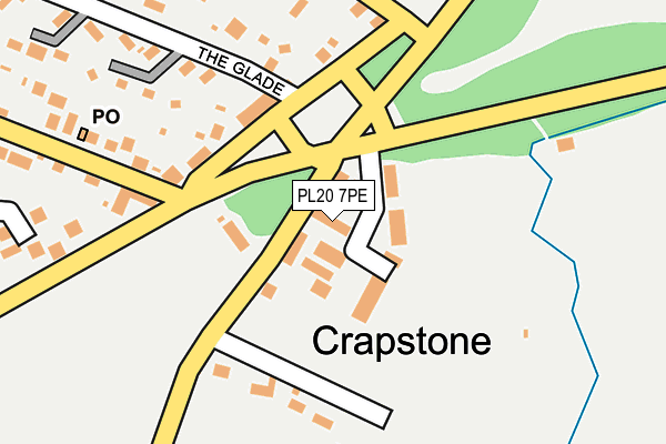
PL20 7PE is located in the Buckland Monachorum electoral ward, within the local authority district of West Devon and the English Parliamentary constituency of Torridge and West Devon. The Sub Integrated Care Board (ICB) Location is NHS Devon ICB - 15N and the police force is Devon & Cornwall. This postcode has been in use since January 1980.


GetTheData
Source: OS OpenMap – Local (Ordnance Survey)
Source: OS VectorMap District (Ordnance Survey)
Licence: Open Government Licence (requires attribution)
| Easting | 250457 |
| Northing | 67746 |
| Latitude | 50.490386 |
| Longitude | -4.109541 |
GetTheData
Source: Open Postcode Geo
Licence: Open Government Licence
| Country | England |
| Postcode District | PL20 |
➜ See where PL20 is on a map ➜ Where is Crapstone? | |
GetTheData
Source: Land Registry Price Paid Data
Licence: Open Government Licence
Elevation or altitude of PL20 7PE as distance above sea level:
| Metres | Feet | |
|---|---|---|
| Elevation | 180m | 591ft |
Elevation is measured from the approximate centre of the postcode, to the nearest point on an OS contour line from OS Terrain 50, which has contour spacing of ten vertical metres.
➜ How high above sea level am I? Find the elevation of your current position using your device's GPS.
GetTheData
Source: Open Postcode Elevation
Licence: Open Government Licence
| Ward | Buckland Monachorum |
| Constituency | Torridge And West Devon |
GetTheData
Source: ONS Postcode Database
Licence: Open Government Licence
| Memorial | Crapstone | 96m |
| Memorial | Crapstone | 101m |
| Village (Grimstone Terrace) | Crapstone | 295m |
| Village (Grimstone Terrace) | Crapstone | 304m |
| Stonemoor Estate | Crapstone | 348m |
GetTheData
Source: NaPTAN
Licence: Open Government Licence
| Median download speed | 80.0Mbps |
| Average download speed | 62.5Mbps |
| Maximum download speed | 80.00Mbps |
| Median upload speed | 20.0Mbps |
| Average upload speed | 15.3Mbps |
| Maximum upload speed | 20.00Mbps |
GetTheData
Source: Ofcom
Licence: Ofcom Terms of Use (requires attribution)
GetTheData
Source: ONS Postcode Database
Licence: Open Government Licence


➜ Get more ratings from the Food Standards Agency
GetTheData
Source: Food Standards Agency
Licence: FSA terms & conditions
| Last Collection | |||
|---|---|---|---|
| Location | Mon-Fri | Sat | Distance |
| Sadlers Shop | 16:00 | 10:45 | 1,882m |
| Chubb Tor | 09:00 | 09:00 | 2,176m |
| Horrabridge Post Office | 17:00 | 10:30 | 2,334m |
GetTheData
Source: Dracos
Licence: Creative Commons Attribution-ShareAlike
The below table lists the International Territorial Level (ITL) codes (formerly Nomenclature of Territorial Units for Statistics (NUTS) codes) and Local Administrative Units (LAU) codes for PL20 7PE:
| ITL 1 Code | Name |
|---|---|
| TLK | South West (England) |
| ITL 2 Code | Name |
| TLK4 | Devon |
| ITL 3 Code | Name |
| TLK43 | Devon CC |
| LAU 1 Code | Name |
| E07000047 | West Devon |
GetTheData
Source: ONS Postcode Directory
Licence: Open Government Licence
The below table lists the Census Output Area (OA), Lower Layer Super Output Area (LSOA), and Middle Layer Super Output Area (MSOA) for PL20 7PE:
| Code | Name | |
|---|---|---|
| OA | E00102915 | |
| LSOA | E01020316 | West Devon 007D |
| MSOA | E02004235 | West Devon 007 |
GetTheData
Source: ONS Postcode Directory
Licence: Open Government Licence
| PL20 7PL | Woodside Terrace | 126m |
| PL20 7PN | 140m | |
| PL20 7NU | 180m | |
| PL20 7PJ | 213m | |
| PL20 7PR | The Glade | 224m |
| PL20 7PH | Lisbon Villas | 242m |
| PL20 7PS | The Crescent | 287m |
| PL20 7UE | Buckland Court | 306m |
| PL20 7PG | 330m | |
| PL20 7PQ | Grimstone Terrace | 357m |
GetTheData
Source: Open Postcode Geo; Land Registry Price Paid Data
Licence: Open Government Licence