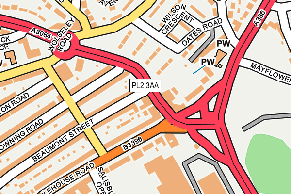
PL2 3AA lies on Wolseley Road in Plymouth. PL2 3AA is located in the Stoke electoral ward, within the unitary authority of Plymouth and the English Parliamentary constituency of Plymouth, Sutton and Devonport. The Sub Integrated Care Board (ICB) Location is NHS Devon ICB - 15N and the police force is Devon & Cornwall. This postcode has been in use since January 1980.


GetTheData
Source: OS OpenMap – Local (Ordnance Survey)
Source: OS VectorMap District (Ordnance Survey)
Licence: Open Government Licence (requires attribution)
| Easting | 246670 |
| Northing | 56228 |
| Latitude | 50.385898 |
| Longitude | -4.158174 |
GetTheData
Source: Open Postcode Geo
Licence: Open Government Licence
| Street | Wolseley Road |
| Town/City | Plymouth |
| Country | England |
| Postcode District | PL2 |
➜ See where PL2 is on a map ➜ Where is Plymouth? | |
GetTheData
Source: Land Registry Price Paid Data
Licence: Open Government Licence
Elevation or altitude of PL2 3AA as distance above sea level:
| Metres | Feet | |
|---|---|---|
| Elevation | 40m | 131ft |
Elevation is measured from the approximate centre of the postcode, to the nearest point on an OS contour line from OS Terrain 50, which has contour spacing of ten vertical metres.
➜ How high above sea level am I? Find the elevation of your current position using your device's GPS.
GetTheData
Source: Open Postcode Elevation
Licence: Open Government Licence
| Ward | Stoke |
| Constituency | Plymouth, Sutton And Devonport |
GetTheData
Source: ONS Postcode Database
Licence: Open Government Licence
| Milehouse Road East (Milehouse Road) | Milehouse | 84m |
| Milehouse Road East (Milehouse Road) | Milehouse | 85m |
| Milehouse Lc 3 (Outland Road) | Milehouse | 142m |
| Queens House (Wolseley Road) | Ford | 149m |
| Milehouse Lc 2 (Alma Road) | Milehouse | 163m |
| Devonport Station | 1.2km |
| Dockyard (Plymouth) Station | 1.3km |
| Plymouth Station | 1.4km |
GetTheData
Source: NaPTAN
Licence: Open Government Licence
| Percentage of properties with Next Generation Access | 80.0% |
| Percentage of properties with Superfast Broadband | 80.0% |
| Percentage of properties with Ultrafast Broadband | 80.0% |
| Percentage of properties with Full Fibre Broadband | 0.0% |
Superfast Broadband is between 30Mbps and 300Mbps
Ultrafast Broadband is > 300Mbps
| Percentage of properties unable to receive 2Mbps | 0.0% |
| Percentage of properties unable to receive 5Mbps | 0.0% |
| Percentage of properties unable to receive 10Mbps | 0.0% |
| Percentage of properties unable to receive 30Mbps | 20.0% |
GetTheData
Source: Ofcom
Licence: Ofcom Terms of Use (requires attribution)
GetTheData
Source: ONS Postcode Database
Licence: Open Government Licence


➜ Get more ratings from the Food Standards Agency
GetTheData
Source: Food Standards Agency
Licence: FSA terms & conditions
| Last Collection | |||
|---|---|---|---|
| Location | Mon-Fri | Sat | Distance |
| Milehouse | 16:45 | 12:00 | 585m |
| Stonehouse Post Office | 18:30 | 12:30 | 617m |
| Henderson Place | 17:00 | 12:00 | 685m |
GetTheData
Source: Dracos
Licence: Creative Commons Attribution-ShareAlike
The below table lists the International Territorial Level (ITL) codes (formerly Nomenclature of Territorial Units for Statistics (NUTS) codes) and Local Administrative Units (LAU) codes for PL2 3AA:
| ITL 1 Code | Name |
|---|---|
| TLK | South West (England) |
| ITL 2 Code | Name |
| TLK4 | Devon |
| ITL 3 Code | Name |
| TLK41 | Plymouth |
| LAU 1 Code | Name |
| E06000026 | Plymouth |
GetTheData
Source: ONS Postcode Directory
Licence: Open Government Licence
The below table lists the Census Output Area (OA), Lower Layer Super Output Area (LSOA), and Middle Layer Super Output Area (MSOA) for PL2 3AA:
| Code | Name | |
|---|---|---|
| OA | E00076645 | |
| LSOA | E01015174 | Plymouth 024D |
| MSOA | E02003145 | Plymouth 024 |
GetTheData
Source: ONS Postcode Directory
Licence: Open Government Licence
| PL2 3AG | Beaumont Street | 74m |
| PL2 3EW | Terra Nova Green | 78m |
| PL3 4DB | Milehouse Road | 81m |
| PL2 3AR | Browning Road | 97m |
| PL2 3BZ | Outland Road | 105m |
| PL2 3ER | Segrave Road | 127m |
| PL3 4AD | Milehouse Road | 131m |
| PL2 3EL | Oates Road | 136m |
| PL2 3EJ | Oates Road | 145m |
| PL2 3EN | Wilson Crescent | 171m |
GetTheData
Source: Open Postcode Geo; Land Registry Price Paid Data
Licence: Open Government Licence