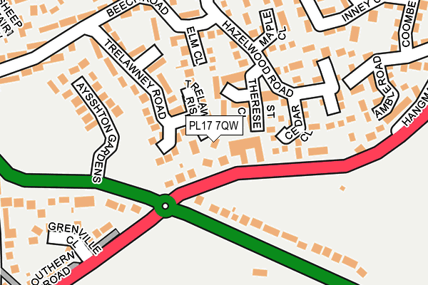
PL17 7QW lies on Trelawney Heights in Callington. PL17 7QW is located in the Callington & St Dominic electoral ward, within the unitary authority of Cornwall and the English Parliamentary constituency of South East Cornwall. The Sub Integrated Care Board (ICB) Location is NHS Cornwall and the Isles of Scilly ICB - 11N and the police force is Devon & Cornwall. This postcode has been in use since September 1991.


GetTheData
Source: OS OpenMap – Local (Ordnance Survey)
Source: OS VectorMap District (Ordnance Survey)
Licence: Open Government Licence (requires attribution)
| Easting | 236373 |
| Northing | 69347 |
| Latitude | 50.501006 |
| Longitude | -4.308628 |
GetTheData
Source: Open Postcode Geo
Licence: Open Government Licence
| Street | Trelawney Heights |
| Town/City | Callington |
| Country | England |
| Postcode District | PL17 |
➜ See where PL17 is on a map ➜ Where is Callington? | |
GetTheData
Source: Land Registry Price Paid Data
Licence: Open Government Licence
Elevation or altitude of PL17 7QW as distance above sea level:
| Metres | Feet | |
|---|---|---|
| Elevation | 170m | 558ft |
Elevation is measured from the approximate centre of the postcode, to the nearest point on an OS contour line from OS Terrain 50, which has contour spacing of ten vertical metres.
➜ How high above sea level am I? Find the elevation of your current position using your device's GPS.
GetTheData
Source: Open Postcode Elevation
Licence: Open Government Licence
| Ward | Callington & St Dominic |
| Constituency | South East Cornwall |
GetTheData
Source: ONS Postcode Database
Licence: Open Government Licence
1, TRELAWNEY HEIGHTS, CALLINGTON, PL17 7QW 2018 23 MAR £265,000 |
3, TRELAWNEY HEIGHTS, CALLINGTON, PL17 7QW 2002 20 SEP £223,000 |
2, TRELAWNEY HEIGHTS, CALLINGTON, PL17 7QW 2001 10 AUG £145,000 |
GetTheData
Source: HM Land Registry Price Paid Data
Licence: Contains HM Land Registry data © Crown copyright and database right 2025. This data is licensed under the Open Government Licence v3.0.
| Southern Road (Saltash Road) | Callington | 124m |
| Southern Road (Saltash Road) | Callington | 129m |
| Elm Close | Callington | 160m |
| Hazelwood Road | Callington | 167m |
| Elm Close (Beech Road) | Callington | 175m |
GetTheData
Source: NaPTAN
Licence: Open Government Licence
| Percentage of properties with Next Generation Access | 100.0% |
| Percentage of properties with Superfast Broadband | 100.0% |
| Percentage of properties with Ultrafast Broadband | 0.0% |
| Percentage of properties with Full Fibre Broadband | 0.0% |
Superfast Broadband is between 30Mbps and 300Mbps
Ultrafast Broadband is > 300Mbps
| Percentage of properties unable to receive 2Mbps | 0.0% |
| Percentage of properties unable to receive 5Mbps | 0.0% |
| Percentage of properties unable to receive 10Mbps | 0.0% |
| Percentage of properties unable to receive 30Mbps | 0.0% |
GetTheData
Source: Ofcom
Licence: Ofcom Terms of Use (requires attribution)
GetTheData
Source: ONS Postcode Database
Licence: Open Government Licence


➜ Get more ratings from the Food Standards Agency
GetTheData
Source: Food Standards Agency
Licence: FSA terms & conditions
| Last Collection | |||
|---|---|---|---|
| Location | Mon-Fri | Sat | Distance |
| Callington Post Office | 17:00 | 12:00 | 511m |
| Bowling Green | 16:30 | 10:00 | 3,335m |
| Harrowbarrow Post Office | 16:15 | 10:00 | 3,444m |
GetTheData
Source: Dracos
Licence: Creative Commons Attribution-ShareAlike
The below table lists the International Territorial Level (ITL) codes (formerly Nomenclature of Territorial Units for Statistics (NUTS) codes) and Local Administrative Units (LAU) codes for PL17 7QW:
| ITL 1 Code | Name |
|---|---|
| TLK | South West (England) |
| ITL 2 Code | Name |
| TLK3 | Cornwall and Isles of Scilly |
| ITL 3 Code | Name |
| TLK30 | Cornwall and Isles of Scilly |
| LAU 1 Code | Name |
| E06000052 | Cornwall |
GetTheData
Source: ONS Postcode Directory
Licence: Open Government Licence
The below table lists the Census Output Area (OA), Lower Layer Super Output Area (LSOA), and Middle Layer Super Output Area (MSOA) for PL17 7QW:
| Code | Name | |
|---|---|---|
| OA | E00094651 | |
| LSOA | E01018750 | Cornwall 013A |
| MSOA | E02003894 | Cornwall 013 |
GetTheData
Source: ONS Postcode Directory
Licence: Open Government Licence
| PL17 7ES | Southern Road | 29m |
| PL17 7QF | St Therese Close | 61m |
| PL17 7PT | Trelawney Rise | 67m |
| PL17 7HG | Cedar Close | 114m |
| PL17 7EX | Elm Close | 131m |
| PL17 7EU | Hazelwood Road | 147m |
| PL17 7EQ | Saltash Road | 154m |
| PL17 7HY | Maple Close | 176m |
| PL17 7JA | Beech Road | 191m |
| PL17 7DW | Aysshton Gardens | 203m |
GetTheData
Source: Open Postcode Geo; Land Registry Price Paid Data
Licence: Open Government Licence