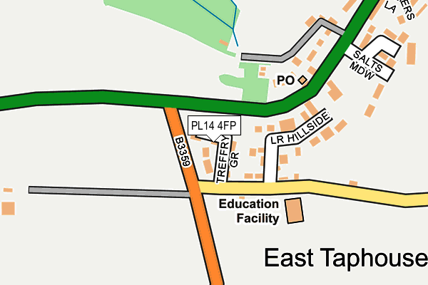
PL14 4FP is located in the Liskeard South & Dobwalls electoral ward, within the unitary authority of Cornwall and the English Parliamentary constituency of South East Cornwall. The Sub Integrated Care Board (ICB) Location is NHS Cornwall and the Isles of Scilly ICB - 11N and the police force is Devon & Cornwall. This postcode has been in use since October 2016.


GetTheData
Source: OS OpenMap – Local (Ordnance Survey)
Source: OS VectorMap District (Ordnance Survey)
Licence: Open Government Licence (requires attribution)
| Easting | 217997 |
| Northing | 63287 |
| Latitude | 50.441126 |
| Longitude | -4.564570 |
GetTheData
Source: Open Postcode Geo
Licence: Open Government Licence
| Country | England |
| Postcode District | PL14 |
➜ See where PL14 is on a map ➜ Where is East Taphouse? | |
GetTheData
Source: Land Registry Price Paid Data
Licence: Open Government Licence
Elevation or altitude of PL14 4FP as distance above sea level:
| Metres | Feet | |
|---|---|---|
| Elevation | 180m | 591ft |
Elevation is measured from the approximate centre of the postcode, to the nearest point on an OS contour line from OS Terrain 50, which has contour spacing of ten vertical metres.
➜ How high above sea level am I? Find the elevation of your current position using your device's GPS.
GetTheData
Source: Open Postcode Elevation
Licence: Open Government Licence
| Ward | Liskeard South & Dobwalls |
| Constituency | South East Cornwall |
GetTheData
Source: ONS Postcode Database
Licence: Open Government Licence
| Jubilee Cottage (A390) | East Taphouse | 325m |
| Post Box (A390) | East Taphouse | 503m |
| The Laurels | Middle Taphouse | 541m |
| The Laurels (A390) | Middle Taphouse | 545m |
| Bus Shelter (A390) | East Taphouse | 576m |
GetTheData
Source: NaPTAN
Licence: Open Government Licence
| Percentage of properties with Next Generation Access | 100.0% |
| Percentage of properties with Superfast Broadband | 92.3% |
| Percentage of properties with Ultrafast Broadband | 0.0% |
| Percentage of properties with Full Fibre Broadband | 0.0% |
Superfast Broadband is between 30Mbps and 300Mbps
Ultrafast Broadband is > 300Mbps
| Median download speed | 25.1Mbps |
| Average download speed | 24.3Mbps |
| Maximum download speed | 34.08Mbps |
| Median upload speed | 5.8Mbps |
| Average upload speed | 5.5Mbps |
| Maximum upload speed | 7.79Mbps |
| Percentage of properties unable to receive 2Mbps | 0.0% |
| Percentage of properties unable to receive 5Mbps | 0.0% |
| Percentage of properties unable to receive 10Mbps | 0.0% |
| Percentage of properties unable to receive 30Mbps | 7.7% |
GetTheData
Source: Ofcom
Licence: Ofcom Terms of Use (requires attribution)
GetTheData
Source: ONS Postcode Database
Licence: Open Government Licence


➜ Get more ratings from the Food Standards Agency
GetTheData
Source: Food Standards Agency
Licence: FSA terms & conditions
| Last Collection | |||
|---|---|---|---|
| Location | Mon-Fri | Sat | Distance |
| Middle Taphouse | 09:15 | 09:15 | 546m |
| Red Post | 15:45 | 08:15 | 1,335m |
| Burnt House (Dobwalls) | 09:00 | 08:30 | 4,608m |
GetTheData
Source: Dracos
Licence: Creative Commons Attribution-ShareAlike
The below table lists the International Territorial Level (ITL) codes (formerly Nomenclature of Territorial Units for Statistics (NUTS) codes) and Local Administrative Units (LAU) codes for PL14 4FP:
| ITL 1 Code | Name |
|---|---|
| TLK | South West (England) |
| ITL 2 Code | Name |
| TLK3 | Cornwall and Isles of Scilly |
| ITL 3 Code | Name |
| TLK30 | Cornwall and Isles of Scilly |
| LAU 1 Code | Name |
| E06000052 | Cornwall |
GetTheData
Source: ONS Postcode Directory
Licence: Open Government Licence
The below table lists the Census Output Area (OA), Lower Layer Super Output Area (LSOA), and Middle Layer Super Output Area (MSOA) for PL14 4FP:
| Code | Name | |
|---|---|---|
| OA | E00094696 | |
| LSOA | E01018758 | Cornwall 016A |
| MSOA | E02003895 | Cornwall 016 |
GetTheData
Source: ONS Postcode Directory
Licence: Open Government Licence
| PL14 4LL | Lower Hillside | 141m |
| PL14 4NL | 201m | |
| PL14 4TG | 220m | |
| PL14 4TA | Salts Meadow | 263m |
| PL14 4NJ | 314m | |
| PL14 4SY | Farmers Close | 360m |
| PL14 4NW | Highway | 474m |
| PL14 4NE | 698m | |
| PL14 4NH | 759m | |
| PL14 4NF | 1205m |
GetTheData
Source: Open Postcode Geo; Land Registry Price Paid Data
Licence: Open Government Licence