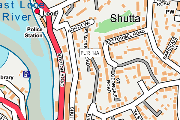
PL13 1JA lies on Elm Tree Road in Looe. PL13 1JA is located in the Looe East & Deviock electoral ward, within the unitary authority of Cornwall and the English Parliamentary constituency of South East Cornwall. The Sub Integrated Care Board (ICB) Location is NHS Cornwall and the Isles of Scilly ICB - 11N and the police force is Devon & Cornwall. This postcode has been in use since January 1980.


GetTheData
Source: OS OpenMap – Local (Ordnance Survey)
Source: OS VectorMap District (Ordnance Survey)
Licence: Open Government Licence (requires attribution)
| Easting | 225554 |
| Northing | 53798 |
| Latitude | 50.358176 |
| Longitude | -4.453804 |
GetTheData
Source: Open Postcode Geo
Licence: Open Government Licence
| Street | Elm Tree Road |
| Town/City | Looe |
| Country | England |
| Postcode District | PL13 |
➜ See where PL13 is on a map ➜ Where is Looe? | |
GetTheData
Source: Land Registry Price Paid Data
Licence: Open Government Licence
Elevation or altitude of PL13 1JA as distance above sea level:
| Metres | Feet | |
|---|---|---|
| Elevation | 60m | 197ft |
Elevation is measured from the approximate centre of the postcode, to the nearest point on an OS contour line from OS Terrain 50, which has contour spacing of ten vertical metres.
➜ How high above sea level am I? Find the elevation of your current position using your device's GPS.
GetTheData
Source: Open Postcode Elevation
Licence: Open Government Licence
| Ward | Looe East & Deviock |
| Constituency | South East Cornwall |
GetTheData
Source: ONS Postcode Database
Licence: Open Government Licence
| Bridge | Looe | 188m |
| Bridge (Station Road) | Looe | 203m |
| Railway Station | Looe | 230m |
| Railway Station (Station Road) | Looe | 238m |
| St Winnolls Park (Barbican Road) | Looe | 315m |
| Looe Station | 0.2km |
| Sandplace Station | 3.3km |
GetTheData
Source: NaPTAN
Licence: Open Government Licence
| Percentage of properties with Next Generation Access | 100.0% |
| Percentage of properties with Superfast Broadband | 100.0% |
| Percentage of properties with Ultrafast Broadband | 0.0% |
| Percentage of properties with Full Fibre Broadband | 0.0% |
Superfast Broadband is between 30Mbps and 300Mbps
Ultrafast Broadband is > 300Mbps
| Percentage of properties unable to receive 2Mbps | 0.0% |
| Percentage of properties unable to receive 5Mbps | 0.0% |
| Percentage of properties unable to receive 10Mbps | 0.0% |
| Percentage of properties unable to receive 30Mbps | 0.0% |
GetTheData
Source: Ofcom
Licence: Ofcom Terms of Use (requires attribution)
GetTheData
Source: ONS Postcode Database
Licence: Open Government Licence


➜ Get more ratings from the Food Standards Agency
GetTheData
Source: Food Standards Agency
Licence: FSA terms & conditions
| Last Collection | |||
|---|---|---|---|
| Location | Mon-Fri | Sat | Distance |
| North Road | 11:15 | 11:15 | 356m |
| Quarry | 11:00 | 10:45 | 384m |
| Looe Post Office | 17:15 | 12:00 | 437m |
GetTheData
Source: Dracos
Licence: Creative Commons Attribution-ShareAlike
The below table lists the International Territorial Level (ITL) codes (formerly Nomenclature of Territorial Units for Statistics (NUTS) codes) and Local Administrative Units (LAU) codes for PL13 1JA:
| ITL 1 Code | Name |
|---|---|
| TLK | South West (England) |
| ITL 2 Code | Name |
| TLK3 | Cornwall and Isles of Scilly |
| ITL 3 Code | Name |
| TLK30 | Cornwall and Isles of Scilly |
| LAU 1 Code | Name |
| E06000052 | Cornwall |
GetTheData
Source: ONS Postcode Directory
Licence: Open Government Licence
The below table lists the Census Output Area (OA), Lower Layer Super Output Area (LSOA), and Middle Layer Super Output Area (MSOA) for PL13 1JA:
| Code | Name | |
|---|---|---|
| OA | E00094769 | |
| LSOA | E01018775 | Cornwall 037C |
| MSOA | E02003904 | Cornwall 037 |
GetTheData
Source: ONS Postcode Directory
Licence: Open Government Licence
| PL13 1JB | Elm Tree Road | 35m |
| PL13 1HS | Hillside Terrace | 65m |
| PL13 1HQ | Pendrim Park | 73m |
| PL13 1HY | Elm Tree Road | 85m |
| PL13 1ED | St Georges Road | 90m |
| PL13 1HN | Station Road | 95m |
| PL13 1HW | Shutta Road | 98m |
| PL13 1EJ | Restormel Road | 117m |
| PL13 1HX | Pendrim Road | 122m |
| PL13 1HR | North View | 128m |
GetTheData
Source: Open Postcode Geo; Land Registry Price Paid Data
Licence: Open Government Licence