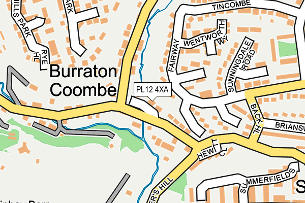
PL12 4XA lies on Nancarrows in Burraton Coombe, Saltash. PL12 4XA is located in the Saltash Trematon & Landrake electoral ward, within the unitary authority of Cornwall and the English Parliamentary constituency of South East Cornwall. The Sub Integrated Care Board (ICB) Location is NHS Cornwall and the Isles of Scilly ICB - 11N and the police force is Devon & Cornwall. This postcode has been in use since January 1993.


GetTheData
Source: OS OpenMap – Local (Ordnance Survey)
Source: OS VectorMap District (Ordnance Survey)
Licence: Open Government Licence (requires attribution)
| Easting | 241312 |
| Northing | 58562 |
| Latitude | 50.405449 |
| Longitude | -4.234469 |
GetTheData
Source: Open Postcode Geo
Licence: Open Government Licence
| Street | Nancarrows |
| Locality | Burraton Coombe |
| Town/City | Saltash |
| Country | England |
| Postcode District | PL12 |
➜ See where PL12 is on a map ➜ Where is Saltash? | |
GetTheData
Source: Land Registry Price Paid Data
Licence: Open Government Licence
Elevation or altitude of PL12 4XA as distance above sea level:
| Metres | Feet | |
|---|---|---|
| Elevation | 20m | 66ft |
Elevation is measured from the approximate centre of the postcode, to the nearest point on an OS contour line from OS Terrain 50, which has contour spacing of ten vertical metres.
➜ How high above sea level am I? Find the elevation of your current position using your device's GPS.
GetTheData
Source: Open Postcode Elevation
Licence: Open Government Licence
| Ward | Saltash Trematon & Landrake |
| Constituency | South East Cornwall |
GetTheData
Source: ONS Postcode Database
Licence: Open Government Licence
2012 4 MAY £300,000 |
2003 29 SEP £222,000 |
2, NANCARROWS, BURRATON COOMBE, SALTASH, PL12 4XA 2001 20 AUG £182,950 |
2, NANCARROWS, BURRATON COOMBE, SALTASH, PL12 4XA 1996 4 DEC £125,750 |
1995 30 JUN £93,000 |
GetTheData
Source: HM Land Registry Price Paid Data
Licence: Contains HM Land Registry data © Crown copyright and database right 2025. This data is licensed under the Open Government Licence v3.0.
| Back Hill | St Stephens | 214m |
| Broom Hill (Maybrook Drive) | St Stephens | 297m |
| Broom Hill (Maybrook Drive) | St Stephens | 309m |
| The Court (Yellowtor Road) | Burraton Coombe | 318m |
| Junction Yellow Tor Road (Yellow Tor Lane) | Saltash | 328m |
| Saltash Station | 1.8km |
| St Budeaux Victoria Road Station | 3.4km |
| St Budeaux Ferry Road Station | 3.4km |
GetTheData
Source: NaPTAN
Licence: Open Government Licence
| Percentage of properties with Next Generation Access | 100.0% |
| Percentage of properties with Superfast Broadband | 100.0% |
| Percentage of properties with Ultrafast Broadband | 100.0% |
| Percentage of properties with Full Fibre Broadband | 0.0% |
Superfast Broadband is between 30Mbps and 300Mbps
Ultrafast Broadband is > 300Mbps
| Percentage of properties unable to receive 2Mbps | 0.0% |
| Percentage of properties unable to receive 5Mbps | 0.0% |
| Percentage of properties unable to receive 10Mbps | 0.0% |
| Percentage of properties unable to receive 30Mbps | 0.0% |
GetTheData
Source: Ofcom
Licence: Ofcom Terms of Use (requires attribution)
GetTheData
Source: ONS Postcode Database
Licence: Open Government Licence


➜ Get more ratings from the Food Standards Agency
GetTheData
Source: Food Standards Agency
Licence: FSA terms & conditions
| Last Collection | |||
|---|---|---|---|
| Location | Mon-Fri | Sat | Distance |
| Tincombe | 17:15 | 11:30 | 326m |
| St Stephens Village | 16:55 | 11:30 | 398m |
| Cross Park Post Office | 17:00 | 11:30 | 744m |
GetTheData
Source: Dracos
Licence: Creative Commons Attribution-ShareAlike
The below table lists the International Territorial Level (ITL) codes (formerly Nomenclature of Territorial Units for Statistics (NUTS) codes) and Local Administrative Units (LAU) codes for PL12 4XA:
| ITL 1 Code | Name |
|---|---|
| TLK | South West (England) |
| ITL 2 Code | Name |
| TLK3 | Cornwall and Isles of Scilly |
| ITL 3 Code | Name |
| TLK30 | Cornwall and Isles of Scilly |
| LAU 1 Code | Name |
| E06000052 | Cornwall |
GetTheData
Source: ONS Postcode Directory
Licence: Open Government Licence
The below table lists the Census Output Area (OA), Lower Layer Super Output Area (LSOA), and Middle Layer Super Output Area (MSOA) for PL12 4XA:
| Code | Name | |
|---|---|---|
| OA | E00094877 | |
| LSOA | E01018794 | Cornwall 025D |
| MSOA | E02003899 | Cornwall 025 |
GetTheData
Source: ONS Postcode Directory
Licence: Open Government Licence
| PL12 4QD | 56m | |
| PL12 4XB | Tannery Court | 57m |
| PL12 4DE | Carnoustie Drive | 64m |
| PL12 4PZ | Down Close | 82m |
| PL12 4DQ | Birkdale Close | 113m |
| PL12 4QB | 115m | |
| PL12 4DF | St Andrews Close | 116m |
| PL12 4HB | Hewitt Close | 158m |
| PL12 4QE | Fairmead Road | 168m |
| PL12 4DG | Wentworth Way | 173m |
GetTheData
Source: Open Postcode Geo; Land Registry Price Paid Data
Licence: Open Government Licence