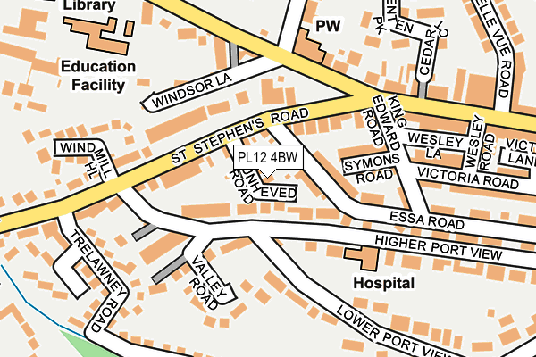
PL12 4BW lies on Dunheved Road in Saltash. PL12 4BW is located in the Saltash Essa electoral ward, within the unitary authority of Cornwall and the English Parliamentary constituency of South East Cornwall. The Sub Integrated Care Board (ICB) Location is NHS Cornwall and the Isles of Scilly ICB - 11N and the police force is Devon & Cornwall. This postcode has been in use since January 1980.


GetTheData
Source: OS OpenMap – Local (Ordnance Survey)
Source: OS VectorMap District (Ordnance Survey)
Licence: Open Government Licence (requires attribution)
| Easting | 242558 |
| Northing | 58828 |
| Latitude | 50.408175 |
| Longitude | -4.217060 |
GetTheData
Source: Open Postcode Geo
Licence: Open Government Licence
| Street | Dunheved Road |
| Town/City | Saltash |
| Country | England |
| Postcode District | PL12 |
➜ See where PL12 is on a map ➜ Where is Saltash? | |
GetTheData
Source: Land Registry Price Paid Data
Licence: Open Government Licence
Elevation or altitude of PL12 4BW as distance above sea level:
| Metres | Feet | |
|---|---|---|
| Elevation | 60m | 197ft |
Elevation is measured from the approximate centre of the postcode, to the nearest point on an OS contour line from OS Terrain 50, which has contour spacing of ten vertical metres.
➜ How high above sea level am I? Find the elevation of your current position using your device's GPS.
GetTheData
Source: Open Postcode Elevation
Licence: Open Government Licence
| Ward | Saltash Essa |
| Constituency | South East Cornwall |
GetTheData
Source: ONS Postcode Database
Licence: Open Government Licence
6, DUNHEVED ROAD, SALTASH, PL12 4BW 2021 25 JAN £342,000 |
GetTheData
Source: HM Land Registry Price Paid Data
Licence: Contains HM Land Registry data © Crown copyright and database right 2025. This data is licensed under the Open Government Licence v3.0.
| Glebe Avenue | Saltash | 158m |
| Glebe Avenue | Saltash | 178m |
| Fore Street Top (Fore Street) | Saltash | 185m |
| Fore Street Top (Fore Street) | Saltash | 185m |
| Windmill Hill (St Stephen's Road) | Wearde | 192m |
| Saltash Station | 0.6km |
| St Budeaux Victoria Road Station | 2.2km |
| St Budeaux Ferry Road Station | 2.3km |
GetTheData
Source: NaPTAN
Licence: Open Government Licence
| Percentage of properties with Next Generation Access | 100.0% |
| Percentage of properties with Superfast Broadband | 100.0% |
| Percentage of properties with Ultrafast Broadband | 90.9% |
| Percentage of properties with Full Fibre Broadband | 0.0% |
Superfast Broadband is between 30Mbps and 300Mbps
Ultrafast Broadband is > 300Mbps
| Median download speed | 88.5Mbps |
| Average download speed | 85.4Mbps |
| Maximum download speed | 200.00Mbps |
| Median upload speed | 10.6Mbps |
| Average upload speed | 10.5Mbps |
| Maximum upload speed | 20.00Mbps |
| Percentage of properties unable to receive 2Mbps | 0.0% |
| Percentage of properties unable to receive 5Mbps | 0.0% |
| Percentage of properties unable to receive 10Mbps | 0.0% |
| Percentage of properties unable to receive 30Mbps | 0.0% |
GetTheData
Source: Ofcom
Licence: Ofcom Terms of Use (requires attribution)
Estimated total energy consumption in PL12 4BW by fuel type, 2015.
| Consumption (kWh) | 179,289 |
|---|---|
| Meter count | 10 |
| Mean (kWh/meter) | 17,929 |
| Median (kWh/meter) | 16,047 |
| Consumption (kWh) | 26,079 |
|---|---|
| Meter count | 9 |
| Mean (kWh/meter) | 2,898 |
| Median (kWh/meter) | 2,288 |
GetTheData
Source: Postcode level gas estimates: 2015 (experimental)
Source: Postcode level electricity estimates: 2015 (experimental)
Licence: Open Government Licence
GetTheData
Source: ONS Postcode Database
Licence: Open Government Licence


➜ Get more ratings from the Food Standards Agency
GetTheData
Source: Food Standards Agency
Licence: FSA terms & conditions
| Last Collection | |||
|---|---|---|---|
| Location | Mon-Fri | Sat | Distance |
| Saltash Delivery Office | 17:30 | 12:30 | 250m |
| Longmeadow Road | 17:00 | 12:15 | 330m |
| Glebe Avenue | 17:00 | 12:15 | 341m |
GetTheData
Source: Dracos
Licence: Creative Commons Attribution-ShareAlike
The below table lists the International Territorial Level (ITL) codes (formerly Nomenclature of Territorial Units for Statistics (NUTS) codes) and Local Administrative Units (LAU) codes for PL12 4BW:
| ITL 1 Code | Name |
|---|---|
| TLK | South West (England) |
| ITL 2 Code | Name |
| TLK3 | Cornwall and Isles of Scilly |
| ITL 3 Code | Name |
| TLK30 | Cornwall and Isles of Scilly |
| LAU 1 Code | Name |
| E06000052 | Cornwall |
GetTheData
Source: ONS Postcode Directory
Licence: Open Government Licence
The below table lists the Census Output Area (OA), Lower Layer Super Output Area (LSOA), and Middle Layer Super Output Area (MSOA) for PL12 4BW:
| Code | Name | |
|---|---|---|
| OA | E00094860 | |
| LSOA | E01018791 | Cornwall 026B |
| MSOA | E02003900 | Cornwall 026 |
GetTheData
Source: ONS Postcode Directory
Licence: Open Government Licence
| PL12 4BX | Higher Port View | 70m |
| PL12 4EE | Essa Road | 80m |
| PL12 4BG | St Stephens Road | 87m |
| PL12 4BQ | St Stephens Road | 98m |
| PL12 4EG | Symons Road | 117m |
| PL12 4BP | Harbour View | 144m |
| PL12 6DT | Warfelton Terrace | 150m |
| PL12 6FA | King Edward Road | 153m |
| PL12 4EQ | King Edward Road | 153m |
| PL12 4BT | Valley Road | 159m |
GetTheData
Source: Open Postcode Geo; Land Registry Price Paid Data
Licence: Open Government Licence