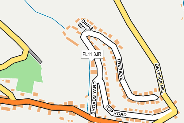
PL11 3JR lies on Trerieve in Downderry, Torpoint. PL11 3JR is located in the Looe East & Deviock electoral ward, within the unitary authority of Cornwall and the English Parliamentary constituency of South East Cornwall. The Sub Integrated Care Board (ICB) Location is NHS Cornwall and the Isles of Scilly ICB - 11N and the police force is Devon & Cornwall. This postcode has been in use since October 2003.


GetTheData
Source: OS OpenMap – Local (Ordnance Survey)
Source: OS VectorMap District (Ordnance Survey)
Licence: Open Government Licence (requires attribution)
| Easting | 231481 |
| Northing | 54222 |
| Latitude | 50.363714 |
| Longitude | -4.370746 |
GetTheData
Source: Open Postcode Geo
Licence: Open Government Licence
| Street | Trerieve |
| Locality | Downderry |
| Town/City | Torpoint |
| Country | England |
| Postcode District | PL11 |
➜ See where PL11 is on a map ➜ Where is Downderry? | |
GetTheData
Source: Land Registry Price Paid Data
Licence: Open Government Licence
Elevation or altitude of PL11 3JR as distance above sea level:
| Metres | Feet | |
|---|---|---|
| Elevation | 40m | 131ft |
Elevation is measured from the approximate centre of the postcode, to the nearest point on an OS contour line from OS Terrain 50, which has contour spacing of ten vertical metres.
➜ How high above sea level am I? Find the elevation of your current position using your device's GPS.
GetTheData
Source: Open Postcode Elevation
Licence: Open Government Licence
| Ward | Looe East & Deviock |
| Constituency | South East Cornwall |
GetTheData
Source: ONS Postcode Database
Licence: Open Government Licence
| Broads Yard | Downderry | 178m |
| Broads Yard | Downderry | 190m |
| Church (Main Road) | Downderry | 450m |
| Church (Main Road) | Downderry | 470m |
| Sea Front (Brenton Road) | Seaton | 1,055m |
| St Germans Station | 5.6km |
GetTheData
Source: NaPTAN
Licence: Open Government Licence
| Percentage of properties with Next Generation Access | 100.0% |
| Percentage of properties with Superfast Broadband | 100.0% |
| Percentage of properties with Ultrafast Broadband | 0.0% |
| Percentage of properties with Full Fibre Broadband | 0.0% |
Superfast Broadband is between 30Mbps and 300Mbps
Ultrafast Broadband is > 300Mbps
| Median download speed | 48.9Mbps |
| Average download speed | 56.0Mbps |
| Maximum download speed | 80.00Mbps |
| Median upload speed | 14.6Mbps |
| Average upload speed | 14.8Mbps |
| Maximum upload speed | 20.00Mbps |
| Percentage of properties unable to receive 2Mbps | 0.0% |
| Percentage of properties unable to receive 5Mbps | 0.0% |
| Percentage of properties unable to receive 10Mbps | 0.0% |
| Percentage of properties unable to receive 30Mbps | 0.0% |
GetTheData
Source: Ofcom
Licence: Ofcom Terms of Use (requires attribution)
Estimated total energy consumption in PL11 3JR by fuel type, 2015.
| Consumption (kWh) | 47,043 |
|---|---|
| Meter count | 7 |
| Mean (kWh/meter) | 6,720 |
| Median (kWh/meter) | 4,110 |
GetTheData
Source: Postcode level gas estimates: 2015 (experimental)
Source: Postcode level electricity estimates: 2015 (experimental)
Licence: Open Government Licence
GetTheData
Source: ONS Postcode Database
Licence: Open Government Licence


➜ Get more ratings from the Food Standards Agency
GetTheData
Source: Food Standards Agency
Licence: FSA terms & conditions
The below table lists the International Territorial Level (ITL) codes (formerly Nomenclature of Territorial Units for Statistics (NUTS) codes) and Local Administrative Units (LAU) codes for PL11 3JR:
| ITL 1 Code | Name |
|---|---|
| TLK | South West (England) |
| ITL 2 Code | Name |
| TLK3 | Cornwall and Isles of Scilly |
| ITL 3 Code | Name |
| TLK30 | Cornwall and Isles of Scilly |
| LAU 1 Code | Name |
| E06000052 | Cornwall |
GetTheData
Source: ONS Postcode Directory
Licence: Open Government Licence
The below table lists the Census Output Area (OA), Lower Layer Super Output Area (LSOA), and Middle Layer Super Output Area (MSOA) for PL11 3JR:
| Code | Name | |
|---|---|---|
| OA | E00094682 | |
| LSOA | E01018757 | Cornwall 023A |
| MSOA | E02003898 | Cornwall 023 |
GetTheData
Source: ONS Postcode Directory
Licence: Open Government Licence
| PL11 3EF | Morweth View | 34m |
| PL11 3LY | Trerieve | 93m |
| PL11 3JP | Morweth Court | 119m |
| PL11 3LX | Trerieve | 138m |
| PL11 3NH | Trerieve | 141m |
| PL11 3JX | 183m | |
| PL11 3LD | 211m | |
| PL11 3LZ | Top Road | 212m |
| PL11 3JZ | 233m | |
| PL11 3LJ | 236m |
GetTheData
Source: Open Postcode Geo; Land Registry Price Paid Data
Licence: Open Government Licence