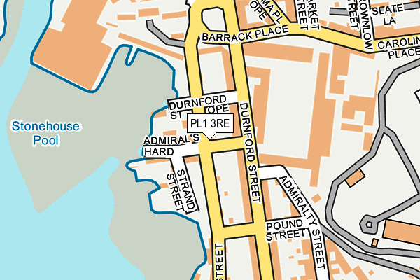
PL1 3RE lies on Cremyll Street in Plymouth. PL1 3RE is located in the St Peter and the Waterfront electoral ward, within the unitary authority of Plymouth and the English Parliamentary constituency of Plymouth, Sutton and Devonport. The Sub Integrated Care Board (ICB) Location is NHS Devon ICB - 15N and the police force is Devon & Cornwall. This postcode has been in use since January 1980.


GetTheData
Source: OS OpenMap – Local (Ordnance Survey)
Source: OS VectorMap District (Ordnance Survey)
Licence: Open Government Licence (requires attribution)
| Easting | 246295 |
| Northing | 54004 |
| Latitude | 50.365813 |
| Longitude | -4.162536 |
GetTheData
Source: Open Postcode Geo
Licence: Open Government Licence
| Street | Cremyll Street |
| Town/City | Plymouth |
| Country | England |
| Postcode District | PL1 |
➜ See where PL1 is on a map ➜ Where is Plymouth? | |
GetTheData
Source: Land Registry Price Paid Data
Licence: Open Government Licence
Elevation or altitude of PL1 3RE as distance above sea level:
| Metres | Feet | |
|---|---|---|
| Elevation | 10m | 33ft |
Elevation is measured from the approximate centre of the postcode, to the nearest point on an OS contour line from OS Terrain 50, which has contour spacing of ten vertical metres.
➜ How high above sea level am I? Find the elevation of your current position using your device's GPS.
GetTheData
Source: Open Postcode Elevation
Licence: Open Government Licence
| Ward | St Peter And The Waterfront |
| Constituency | Plymouth, Sutton And Devonport |
GetTheData
Source: ONS Postcode Database
Licence: Open Government Licence
92, CREMYLL STREET, PLYMOUTH, PL1 3RE 2019 22 AUG £235,000 |
33, CREMYLL STREET, PLYMOUTH, PL1 3RE 2012 30 MAR £150,000 |
SPRINGTIDE, 92, CREMYLL STREET, PLYMOUTH, PL1 3RE 2003 7 JUL £160,000 |
GetTheData
Source: HM Land Registry Price Paid Data
Licence: Contains HM Land Registry data © Crown copyright and database right 2025. This data is licensed under the Open Government Licence v3.0.
| Admiral's Hard (Cremyll Street) | Stonehouse | 37m |
| Admiralty Street (Durnford Street) | Stonehouse | 67m |
| Stonehall Flats (Cremyll Street) | Stonehouse | 117m |
| Emma Place Ope | Stonehouse | 206m |
| Market Street (Caroline Place) | Stonehouse | 218m |
| Devonport Station | 1.5km |
| Plymouth Station | 1.9km |
| Dockyard (Plymouth) Station | 2.1km |
GetTheData
Source: NaPTAN
Licence: Open Government Licence
| Percentage of properties with Next Generation Access | 100.0% |
| Percentage of properties with Superfast Broadband | 100.0% |
| Percentage of properties with Ultrafast Broadband | 40.0% |
| Percentage of properties with Full Fibre Broadband | 0.0% |
Superfast Broadband is between 30Mbps and 300Mbps
Ultrafast Broadband is > 300Mbps
| Percentage of properties unable to receive 2Mbps | 0.0% |
| Percentage of properties unable to receive 5Mbps | 0.0% |
| Percentage of properties unable to receive 10Mbps | 0.0% |
| Percentage of properties unable to receive 30Mbps | 0.0% |
GetTheData
Source: Ofcom
Licence: Ofcom Terms of Use (requires attribution)
GetTheData
Source: ONS Postcode Database
Licence: Open Government Licence


➜ Get more ratings from the Food Standards Agency
GetTheData
Source: Food Standards Agency
Licence: FSA terms & conditions
| Last Collection | |||
|---|---|---|---|
| Location | Mon-Fri | Sat | Distance |
| Durnford Street | 18:30 | 12:15 | 118m |
| Lower Durnford Street | 18:30 | 12:15 | 240m |
| Richmond Walk | 17:30 | 12:45 | 379m |
GetTheData
Source: Dracos
Licence: Creative Commons Attribution-ShareAlike
The below table lists the International Territorial Level (ITL) codes (formerly Nomenclature of Territorial Units for Statistics (NUTS) codes) and Local Administrative Units (LAU) codes for PL1 3RE:
| ITL 1 Code | Name |
|---|---|
| TLK | South West (England) |
| ITL 2 Code | Name |
| TLK4 | Devon |
| ITL 3 Code | Name |
| TLK41 | Plymouth |
| LAU 1 Code | Name |
| E06000026 | Plymouth |
GetTheData
Source: ONS Postcode Directory
Licence: Open Government Licence
The below table lists the Census Output Area (OA), Lower Layer Super Output Area (LSOA), and Middle Layer Super Output Area (MSOA) for PL1 3RE:
| Code | Name | |
|---|---|---|
| OA | E00076582 | |
| LSOA | E01015157 | Plymouth 029D |
| MSOA | E02003150 | Plymouth 029 |
GetTheData
Source: ONS Postcode Directory
Licence: Open Government Licence
| PL1 3RJ | Admirals Hard | 42m |
| PL1 3RA | Cremyll Street | 67m |
| PL1 3RL | Strand Street | 68m |
| PL1 3QN | Durnford Street | 83m |
| PL1 3QW | Durnford Street | 94m |
| PL1 3RG | Barrack Place | 125m |
| PL1 3RY | Admiralty Street | 125m |
| PL1 3RH | Pound Street | 168m |
| PL1 3FE | Barrack Place | 171m |
| PL1 3EU | Durnford Street | 179m |
GetTheData
Source: Open Postcode Geo; Land Registry Price Paid Data
Licence: Open Government Licence