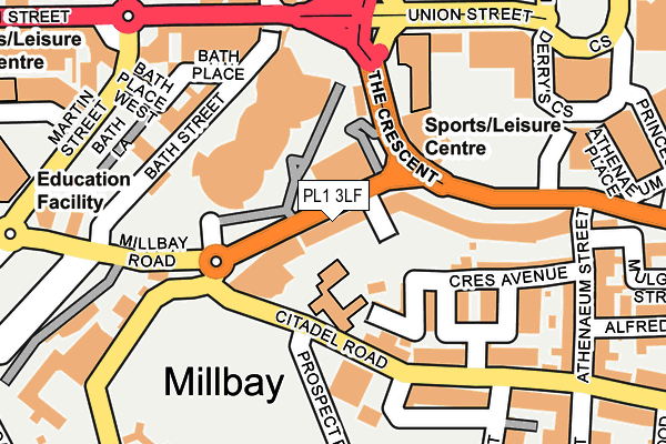
PL1 3LF is located in the St Peter and the Waterfront electoral ward, within the unitary authority of Plymouth and the English Parliamentary constituency of Plymouth, Sutton and Devonport. The Sub Integrated Care Board (ICB) Location is NHS Devon ICB - 15N and the police force is Devon & Cornwall. This postcode has been in use since January 1980.


GetTheData
Source: OS OpenMap – Local (Ordnance Survey)
Source: OS VectorMap District (Ordnance Survey)
Licence: Open Government Licence (requires attribution)
| Easting | 247271 |
| Northing | 54237 |
| Latitude | 50.368147 |
| Longitude | -4.148947 |
GetTheData
Source: Open Postcode Geo
Licence: Open Government Licence
| Country | England |
| Postcode District | PL1 |
➜ See where PL1 is on a map ➜ Where is Plymouth? | |
GetTheData
Source: Land Registry Price Paid Data
Licence: Open Government Licence
Elevation or altitude of PL1 3LF as distance above sea level:
| Metres | Feet | |
|---|---|---|
| Elevation | 10m | 33ft |
Elevation is measured from the approximate centre of the postcode, to the nearest point on an OS contour line from OS Terrain 50, which has contour spacing of ten vertical metres.
➜ How high above sea level am I? Find the elevation of your current position using your device's GPS.
GetTheData
Source: Open Postcode Elevation
Licence: Open Government Licence
| Ward | St Peter And The Waterfront |
| Constituency | Plymouth, Sutton And Devonport |
GetTheData
Source: ONS Postcode Database
Licence: Open Government Licence
| New Continental Hotel (Millbay Road) | West Hoe | 26m |
| Durley House (Millbay Road) | West Hoe | 31m |
| Pavilions Forecourt | West Hoe | 58m |
| St Andrews School (Citadel Road) | The Hoe | 104m |
| Pavilions (Union Street) | Plymouth | 183m |
| Plymouth Station | 1.1km |
| Devonport Station | 1.9km |
| Dockyard (Plymouth) Station | 2.5km |
GetTheData
Source: NaPTAN
Licence: Open Government Licence
GetTheData
Source: ONS Postcode Database
Licence: Open Government Licence


➜ Get more ratings from the Food Standards Agency
GetTheData
Source: Food Standards Agency
Licence: FSA terms & conditions
| Last Collection | |||
|---|---|---|---|
| Location | Mon-Fri | Sat | Distance |
| Duke Of Cornwall (Out) | 19:00 | 12:15 | 137m |
| Citadel Road | 19:00 | 12:15 | 276m |
| Derrys Cross | 18:45 | 12:00 | 301m |
GetTheData
Source: Dracos
Licence: Creative Commons Attribution-ShareAlike
The below table lists the International Territorial Level (ITL) codes (formerly Nomenclature of Territorial Units for Statistics (NUTS) codes) and Local Administrative Units (LAU) codes for PL1 3LF:
| ITL 1 Code | Name |
|---|---|
| TLK | South West (England) |
| ITL 2 Code | Name |
| TLK4 | Devon |
| ITL 3 Code | Name |
| TLK41 | Plymouth |
| LAU 1 Code | Name |
| E06000026 | Plymouth |
GetTheData
Source: ONS Postcode Directory
Licence: Open Government Licence
The below table lists the Census Output Area (OA), Lower Layer Super Output Area (LSOA), and Middle Layer Super Output Area (MSOA) for PL1 3LF:
| Code | Name | |
|---|---|---|
| OA | E00172053 | |
| LSOA | E01015158 | Plymouth 029E |
| MSOA | E02003150 | Plymouth 029 |
GetTheData
Source: ONS Postcode Directory
Licence: Open Government Licence
| PL1 3DT | Crescent Avenue | 90m |
| PL1 3LB | Millbay Road | 91m |
| PL1 3FH | The Crescent | 112m |
| PL1 3FG | The Crescent | 114m |
| PL1 3BG | Citadel Road | 116m |
| PL1 3AP | Crescent Avenue Mews | 126m |
| PL1 3AB | The Crescent | 137m |
| PL1 3AT | St James Place West | 143m |
| PL1 3AU | Citadel Road | 155m |
| PL1 3LH | Millbay Road | 160m |
GetTheData
Source: Open Postcode Geo; Land Registry Price Paid Data
Licence: Open Government Licence