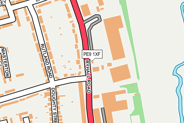
PE9 1XF lies on Martin Markhams Yard in Stamford. PE9 1XF is located in the Stamford St George's electoral ward, within the local authority district of South Kesteven and the English Parliamentary constituency of Grantham and Stamford. The Sub Integrated Care Board (ICB) Location is NHS Lincolnshire ICB - 71E and the police force is Lincolnshire. This postcode has been in use since December 1995.


GetTheData
Source: OS OpenMap – Local (Ordnance Survey)
Source: OS VectorMap District (Ordnance Survey)
Licence: Open Government Licence (requires attribution)
| Easting | 503849 |
| Northing | 308226 |
| Latitude | 52.661817 |
| Longitude | -0.465967 |
GetTheData
Source: Open Postcode Geo
Licence: Open Government Licence
| Street | Martin Markhams Yard |
| Town/City | Stamford |
| Country | England |
| Postcode District | PE9 |
➜ See where PE9 is on a map ➜ Where is Stamford? | |
GetTheData
Source: Land Registry Price Paid Data
Licence: Open Government Licence
Elevation or altitude of PE9 1XF as distance above sea level:
| Metres | Feet | |
|---|---|---|
| Elevation | 30m | 98ft |
Elevation is measured from the approximate centre of the postcode, to the nearest point on an OS contour line from OS Terrain 50, which has contour spacing of ten vertical metres.
➜ How high above sea level am I? Find the elevation of your current position using your device's GPS.
GetTheData
Source: Open Postcode Elevation
Licence: Open Government Licence
| Ward | Stamford St George's |
| Constituency | Grantham And Stamford |
GetTheData
Source: ONS Postcode Database
Licence: Open Government Licence
FLAT, MARTINS COTTAGE, MARTIN MARKHAMS YARD, STAMFORD, PE9 1XF 2021 17 MAR £250,000 |
GetTheData
Source: HM Land Registry Price Paid Data
Licence: Contains HM Land Registry data © Crown copyright and database right 2025. This data is licensed under the Open Government Licence v3.0.
| Drift Road (Ryhall Road) | Stamford | 190m |
| Drift Road (Ryhall Road) | Stamford | 200m |
| Guash Way (Ryhall Road) | Stamford | 217m |
| Bowling Green (Lincoln Road) | Stamford | 231m |
| Bowling Green (Lincoln Road) | Stamford | 247m |
| Stamford Station | 1.8km |
GetTheData
Source: NaPTAN
Licence: Open Government Licence
GetTheData
Source: ONS Postcode Database
Licence: Open Government Licence


➜ Get more ratings from the Food Standards Agency
GetTheData
Source: Food Standards Agency
Licence: FSA terms & conditions
| Last Collection | |||
|---|---|---|---|
| Location | Mon-Fri | Sat | Distance |
| Doughty Street | 17:30 | 10:45 | 127m |
| Ryhall Road Post Office | 17:30 | 11:15 | 462m |
| Drift Estate | 17:30 | 10:45 | 617m |
GetTheData
Source: Dracos
Licence: Creative Commons Attribution-ShareAlike
The below table lists the International Territorial Level (ITL) codes (formerly Nomenclature of Territorial Units for Statistics (NUTS) codes) and Local Administrative Units (LAU) codes for PE9 1XF:
| ITL 1 Code | Name |
|---|---|
| TLF | East Midlands (England) |
| ITL 2 Code | Name |
| TLF3 | Lincolnshire |
| ITL 3 Code | Name |
| TLF30 | Lincolnshire CC |
| LAU 1 Code | Name |
| E07000141 | South Kesteven |
GetTheData
Source: ONS Postcode Directory
Licence: Open Government Licence
The below table lists the Census Output Area (OA), Lower Layer Super Output Area (LSOA), and Middle Layer Super Output Area (MSOA) for PE9 1XF:
| Code | Name | |
|---|---|---|
| OA | E00133827 | |
| LSOA | E01026346 | South Kesteven 015D |
| MSOA | E02005490 | South Kesteven 015 |
GetTheData
Source: ONS Postcode Directory
Licence: Open Government Licence
| PE9 1UR | Rutland Road | 81m |
| PE9 1UL | Ryhall Road | 103m |
| PE9 1UJ | Ryhall Road | 158m |
| PE9 1UP | Rutland Road | 188m |
| PE9 1UT | Doughty Street | 211m |
| PE9 1UW | Rutland Road | 241m |
| PE9 1UU | Lincoln Road | 280m |
| PE9 1UZ | Drift Road | 295m |
| PE9 1SL | Masterton Close | 300m |
| PE9 1DU | Losecoat Close | 300m |
GetTheData
Source: Open Postcode Geo; Land Registry Price Paid Data
Licence: Open Government Licence