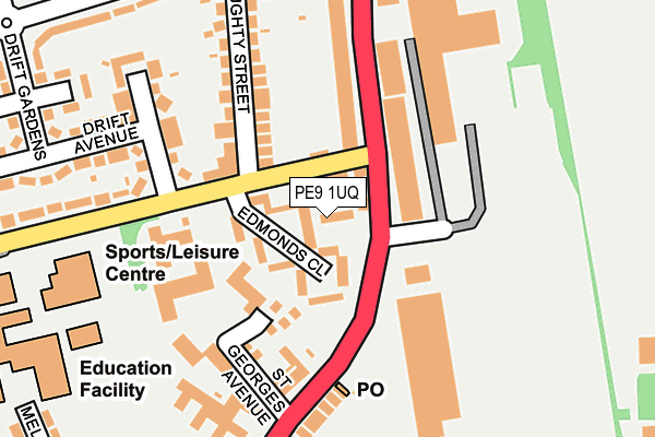
PE9 1UQ lies on Ryhall Road in Stamford. PE9 1UQ is located in the Stamford St George's electoral ward, within the local authority district of South Kesteven and the English Parliamentary constituency of Grantham and Stamford. The Sub Integrated Care Board (ICB) Location is NHS Lincolnshire ICB - 71E and the police force is Lincolnshire. This postcode has been in use since January 1980.


GetTheData
Source: OS OpenMap – Local (Ordnance Survey)
Source: OS VectorMap District (Ordnance Survey)
Licence: Open Government Licence (requires attribution)
| Easting | 503808 |
| Northing | 307911 |
| Latitude | 52.658994 |
| Longitude | -0.466672 |
GetTheData
Source: Open Postcode Geo
Licence: Open Government Licence
| Street | Ryhall Road |
| Town/City | Stamford |
| Country | England |
| Postcode District | PE9 |
➜ See where PE9 is on a map ➜ Where is Stamford? | |
GetTheData
Source: Land Registry Price Paid Data
Licence: Open Government Licence
Elevation or altitude of PE9 1UQ as distance above sea level:
| Metres | Feet | |
|---|---|---|
| Elevation | 30m | 98ft |
Elevation is measured from the approximate centre of the postcode, to the nearest point on an OS contour line from OS Terrain 50, which has contour spacing of ten vertical metres.
➜ How high above sea level am I? Find the elevation of your current position using your device's GPS.
GetTheData
Source: Open Postcode Elevation
Licence: Open Government Licence
| Ward | Stamford St George's |
| Constituency | Grantham And Stamford |
GetTheData
Source: ONS Postcode Database
Licence: Open Government Licence
| Drift Road (Ryhall Road) | Stamford | 123m |
| Drift Road (Ryhall Road) | Stamford | 129m |
| Stamford & Rutland Hospital (Ryhall Road) | Stamford | 272m |
| Bowling Green (Lincoln Road) | Stamford | 277m |
| Bowling Green (Lincoln Road) | Stamford | 286m |
| Stamford Station | 1.5km |
GetTheData
Source: NaPTAN
Licence: Open Government Licence
| Percentage of properties with Next Generation Access | 100.0% |
| Percentage of properties with Superfast Broadband | 100.0% |
| Percentage of properties with Ultrafast Broadband | 0.0% |
| Percentage of properties with Full Fibre Broadband | 0.0% |
Superfast Broadband is between 30Mbps and 300Mbps
Ultrafast Broadband is > 300Mbps
| Percentage of properties unable to receive 2Mbps | 0.0% |
| Percentage of properties unable to receive 5Mbps | 0.0% |
| Percentage of properties unable to receive 10Mbps | 0.0% |
| Percentage of properties unable to receive 30Mbps | 0.0% |
GetTheData
Source: Ofcom
Licence: Ofcom Terms of Use (requires attribution)
GetTheData
Source: ONS Postcode Database
Licence: Open Government Licence


➜ Get more ratings from the Food Standards Agency
GetTheData
Source: Food Standards Agency
Licence: FSA terms & conditions
| Last Collection | |||
|---|---|---|---|
| Location | Mon-Fri | Sat | Distance |
| Ryhall Road Post Office | 17:30 | 11:15 | 146m |
| Doughty Street | 17:30 | 10:45 | 279m |
| Drift Estate | 17:30 | 10:45 | 511m |
GetTheData
Source: Dracos
Licence: Creative Commons Attribution-ShareAlike
The below table lists the International Territorial Level (ITL) codes (formerly Nomenclature of Territorial Units for Statistics (NUTS) codes) and Local Administrative Units (LAU) codes for PE9 1UQ:
| ITL 1 Code | Name |
|---|---|
| TLF | East Midlands (England) |
| ITL 2 Code | Name |
| TLF3 | Lincolnshire |
| ITL 3 Code | Name |
| TLF30 | Lincolnshire CC |
| LAU 1 Code | Name |
| E07000141 | South Kesteven |
GetTheData
Source: ONS Postcode Directory
Licence: Open Government Licence
The below table lists the Census Output Area (OA), Lower Layer Super Output Area (LSOA), and Middle Layer Super Output Area (MSOA) for PE9 1UQ:
| Code | Name | |
|---|---|---|
| OA | E00133827 | |
| LSOA | E01026346 | South Kesteven 015D |
| MSOA | E02005490 | South Kesteven 015 |
GetTheData
Source: ONS Postcode Directory
Licence: Open Government Licence
| PE9 1UZ | Drift Road | 35m |
| PE9 1XY | St Georges Avenue | 112m |
| PE9 1UH | Blackstones Court | 147m |
| PE9 1UT | Doughty Street | 150m |
| PE9 1XG | Hillary Close | 156m |
| PE9 1UJ | Ryhall Road | 161m |
| PE9 1UF | Ryhall Road | 199m |
| PE9 1UY | Drift Avenue | 261m |
| PE9 1UR | Rutland Road | 276m |
| PE9 1UU | Lincoln Road | 278m |
GetTheData
Source: Open Postcode Geo; Land Registry Price Paid Data
Licence: Open Government Licence