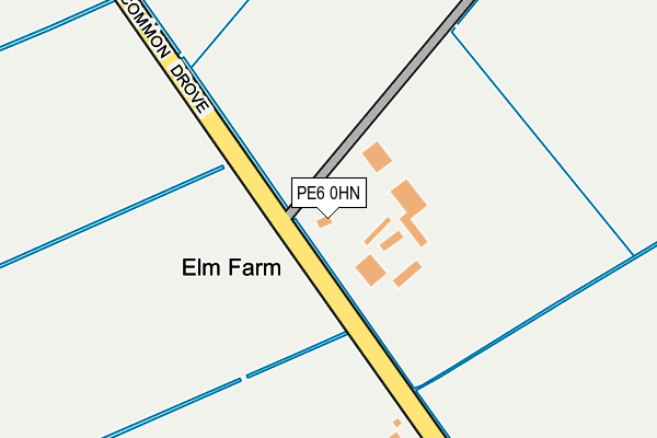
PE6 0HN is located in the Crowland and Deeping St Nicholas electoral ward, within the local authority district of South Holland and the English Parliamentary constituency of South Holland and The Deepings. The Sub Integrated Care Board (ICB) Location is NHS Lincolnshire ICB - 71E and the police force is Lincolnshire. This postcode has been in use since June 2017.


GetTheData
Source: OS OpenMap – Local (Ordnance Survey)
Source: OS VectorMap District (Ordnance Survey)
Licence: Open Government Licence (requires attribution)
| Easting | 522116 |
| Northing | 311667 |
| Latitude | 52.688953 |
| Longitude | -0.194725 |
GetTheData
Source: Open Postcode Geo
Licence: Open Government Licence
| Country | England |
| Postcode District | PE6 |
| ➜ PE6 open data dashboard ➜ See where PE6 is on a map | |
GetTheData
Source: Land Registry Price Paid Data
Licence: Open Government Licence
| Ward | Crowland And Deeping St Nicholas |
| Constituency | South Holland And The Deepings |
GetTheData
Source: ONS Postcode Database
Licence: Open Government Licence
| September 2021 | Anti-social behaviour | On or near Common Drove | 254m |
| ➜ Get more crime data in our Crime section | |||
GetTheData
Source: data.police.uk
Licence: Open Government Licence
GetTheData
Source: ONS Postcode Database
Licence: Open Government Licence

➜ Get more ratings from the Food Standards Agency
GetTheData
Source: Food Standards Agency
Licence: FSA terms & conditions
| Last Collection | |||
|---|---|---|---|
| Location | Mon-Fri | Sat | Distance |
| Crowland Post Office | 16:50 | 11:45 | 2,257m |
| Broadway | 16:30 | 09:45 | 2,326m |
| Albion Street | 16:45 | 09:45 | 2,352m |
GetTheData
Source: Dracos
Licence: Creative Commons Attribution-ShareAlike
| Facility | Distance |
|---|---|
| Crowland Leisure And Wellbeing Centre Postland Road, Crowland, Spalding Sports Hall, Health and Fitness Gym, Grass Pitches | 2.2km |
| South View Primary School Postland Road, Crowland, Peterborough Grass Pitches, Swimming Pool | 2.3km |
| Snowden Field Thorney Road, Crowland, Peterborough Grass Pitches, Outdoor Tennis Courts | 2.6km |
GetTheData
Source: Active Places
Licence: Open Government Licence
| School | Phase of Education | Distance |
|---|---|---|
| South View Community Primary School Postland Road, Crowland, Peterborough, PE6 0JA | Primary | 2.3km |
| Deeping St Nicholas Primary School Main Road, Deeping St Nicholas, Spalding, PE11 3DG | Primary | 3.7km |
GetTheData
Source: Edubase
Licence: Open Government Licence
| Risk of PE6 0HN flooding from rivers and sea | Very Low |
| ➜ PE6 0HN flood map | |
GetTheData
Source: Open Flood Risk by Postcode
Licence: Open Government Licence
The below table lists the International Territorial Level (ITL) codes (formerly Nomenclature of Territorial Units for Statistics (NUTS) codes) and Local Administrative Units (LAU) codes for PE6 0HN:
| ITL 1 Code | Name |
|---|---|
| TLF | East Midlands (England) |
| ITL 2 Code | Name |
| TLF3 | Lincolnshire |
| ITL 3 Code | Name |
| TLF30 | Lincolnshire CC |
| LAU 1 Code | Name |
| E07000140 | South Holland |
GetTheData
Source: ONS Postcode Directory
Licence: Open Government Licence
The below table lists the Census Output Area (OA), Lower Layer Super Output Area (LSOA), and Middle Layer Super Output Area (MSOA) for PE6 0HN:
| Code | Name | |
|---|---|---|
| OA | E00133250 | |
| LSOA | E01026239 | South Holland 011A |
| MSOA | E02005475 | South Holland 011 |
GetTheData
Source: ONS Postcode Directory
Licence: Open Government Licence
| PE6 0HL | The Common | 153m |
| PE6 0HP | West Bank | 2004m |
| PE6 0DJ | Foreman Way | 2050m |
| PE6 0HQ | The Willows | 2070m |
| PE6 0HE | Kemp Street | 2130m |
| PE6 0EF | North Street | 2138m |
| PE6 0EQ | St Marks Drive | 2139m |
| PE6 0BU | Broadway | 2164m |
| PE6 0EG | North Street | 2166m |
| PE6 0EE | West Street | 2177m |
GetTheData
Source: Open Postcode Geo; Land Registry Price Paid Data
Licence: Open Government Licence