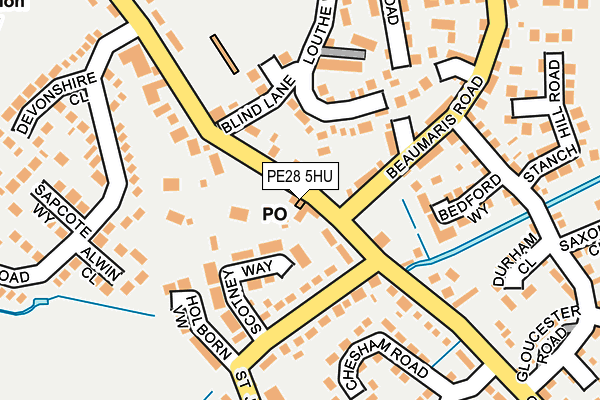
PE28 5HU is located in the Sawtry electoral ward, within the local authority district of Huntingdonshire and the English Parliamentary constituency of North West Cambridgeshire. The Sub Integrated Care Board (ICB) Location is NHS Cambridgeshire and Peterborough ICB - 06H and the police force is Cambridgeshire. This postcode has been in use since March 2013.


GetTheData
Source: OS OpenMap – Local (Ordnance Survey)
Source: OS VectorMap District (Ordnance Survey)
Licence: Open Government Licence (requires attribution)
| Easting | 517100 |
| Northing | 283067 |
| Latitude | 52.433047 |
| Longitude | -0.279002 |
GetTheData
Source: Open Postcode Geo
Licence: Open Government Licence
| Country | England |
| Postcode District | PE28 |
➜ See where PE28 is on a map ➜ Where is Sawtry? | |
GetTheData
Source: Land Registry Price Paid Data
Licence: Open Government Licence
Elevation or altitude of PE28 5HU as distance above sea level:
| Metres | Feet | |
|---|---|---|
| Elevation | 10m | 33ft |
Elevation is measured from the approximate centre of the postcode, to the nearest point on an OS contour line from OS Terrain 50, which has contour spacing of ten vertical metres.
➜ How high above sea level am I? Find the elevation of your current position using your device's GPS.
GetTheData
Source: Open Postcode Elevation
Licence: Open Government Licence
| Ward | Sawtry |
| Constituency | North West Cambridgeshire |
GetTheData
Source: ONS Postcode Database
Licence: Open Government Licence
| Beaumaris Road (Green End Road) | Sawtry | 37m |
| Beaumaris Road (Green End Road) | Sawtry | 64m |
| Middlefield Road (Green End Road) | Sawtry | 424m |
| Cotton Close (Green End Road) | Sawtry | 430m |
| Cotton Close (Green End Road) | Sawtry | 440m |
GetTheData
Source: NaPTAN
Licence: Open Government Licence
GetTheData
Source: ONS Postcode Database
Licence: Open Government Licence


➜ Get more ratings from the Food Standards Agency
GetTheData
Source: Food Standards Agency
Licence: FSA terms & conditions
| Last Collection | |||
|---|---|---|---|
| Location | Mon-Fri | Sat | Distance |
| Sawtry Post Office | 16:45 | 10:45 | 26m |
| Green End Road Sawtry | 16:30 | 10:45 | 276m |
| Fen Lane Sawtry | 16:30 | 10:45 | 498m |
GetTheData
Source: Dracos
Licence: Creative Commons Attribution-ShareAlike
The below table lists the International Territorial Level (ITL) codes (formerly Nomenclature of Territorial Units for Statistics (NUTS) codes) and Local Administrative Units (LAU) codes for PE28 5HU:
| ITL 1 Code | Name |
|---|---|
| TLH | East |
| ITL 2 Code | Name |
| TLH1 | East Anglia |
| ITL 3 Code | Name |
| TLH12 | Cambridgeshire CC |
| LAU 1 Code | Name |
| E07000011 | Huntingdonshire |
GetTheData
Source: ONS Postcode Directory
Licence: Open Government Licence
The below table lists the Census Output Area (OA), Lower Layer Super Output Area (LSOA), and Middle Layer Super Output Area (MSOA) for PE28 5HU:
| Code | Name | |
|---|---|---|
| OA | E00091778 | |
| LSOA | E01018193 | Huntingdonshire 004C |
| MSOA | E02003756 | Huntingdonshire 004 |
GetTheData
Source: ONS Postcode Directory
Licence: Open Government Licence
| PE28 5UZ | Green End Road | 8m |
| PE28 5XF | Scotney Way | 98m |
| PE28 5TR | Louthe Way | 123m |
| PE28 5GG | College Court | 133m |
| PE28 5FF | Spriggs Close | 146m |
| PE28 5QL | Bedford Way | 148m |
| PE28 5GR | Holborn View | 176m |
| PE28 5XH | Alwin Close | 185m |
| PE28 5TW | Moyne Road | 204m |
| PE28 5XB | Chesham Road | 207m |
GetTheData
Source: Open Postcode Geo; Land Registry Price Paid Data
Licence: Open Government Licence