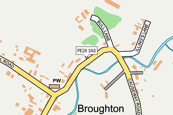
PE28 3AS lies on Causeway Road in Broughton, Huntingdon. PE28 3AS is located in the Warboys electoral ward, within the local authority district of Huntingdonshire and the English Parliamentary constituency of North West Cambridgeshire. The Sub Integrated Care Board (ICB) Location is NHS Cambridgeshire and Peterborough ICB - 06H and the police force is Cambridgeshire. This postcode has been in use since June 2000.


GetTheData
Source: OS OpenMap – Local (Ordnance Survey)
Source: OS VectorMap District (Ordnance Survey)
Licence: Open Government Licence (requires attribution)
| Easting | 528176 |
| Northing | 278005 |
| Latitude | 52.385082 |
| Longitude | -0.118113 |
GetTheData
Source: Open Postcode Geo
Licence: Open Government Licence
| Street | Causeway Road |
| Locality | Broughton |
| Town/City | Huntingdon |
| Country | England |
| Postcode District | PE28 |
➜ See where PE28 is on a map ➜ Where is Broughton? | |
GetTheData
Source: Land Registry Price Paid Data
Licence: Open Government Licence
Elevation or altitude of PE28 3AS as distance above sea level:
| Metres | Feet | |
|---|---|---|
| Elevation | 20m | 66ft |
Elevation is measured from the approximate centre of the postcode, to the nearest point on an OS contour line from OS Terrain 50, which has contour spacing of ten vertical metres.
➜ How high above sea level am I? Find the elevation of your current position using your device's GPS.
GetTheData
Source: Open Postcode Elevation
Licence: Open Government Licence
| Ward | Warboys |
| Constituency | North West Cambridgeshire |
GetTheData
Source: ONS Postcode Database
Licence: Open Government Licence
| School Road (Bridge Road) | Broughton | 189m |
| School Road (Bridge Road) | Broughton | 194m |
GetTheData
Source: NaPTAN
Licence: Open Government Licence
| Percentage of properties with Next Generation Access | 100.0% |
| Percentage of properties with Superfast Broadband | 100.0% |
| Percentage of properties with Ultrafast Broadband | 100.0% |
| Percentage of properties with Full Fibre Broadband | 100.0% |
Superfast Broadband is between 30Mbps and 300Mbps
Ultrafast Broadband is > 300Mbps
| Percentage of properties unable to receive 2Mbps | 0.0% |
| Percentage of properties unable to receive 5Mbps | 0.0% |
| Percentage of properties unable to receive 10Mbps | 0.0% |
| Percentage of properties unable to receive 30Mbps | 0.0% |
GetTheData
Source: Ofcom
Licence: Ofcom Terms of Use (requires attribution)
GetTheData
Source: ONS Postcode Database
Licence: Open Government Licence


➜ Get more ratings from the Food Standards Agency
GetTheData
Source: Food Standards Agency
Licence: FSA terms & conditions
| Last Collection | |||
|---|---|---|---|
| Location | Mon-Fri | Sat | Distance |
| Warboys Airfield | 17:00 | 10:20 | 1,965m |
| Kings Ripton | 16:50 | 09:55 | 2,523m |
| Wistow | 16:50 | 09:00 | 2,966m |
GetTheData
Source: Dracos
Licence: Creative Commons Attribution-ShareAlike
The below table lists the International Territorial Level (ITL) codes (formerly Nomenclature of Territorial Units for Statistics (NUTS) codes) and Local Administrative Units (LAU) codes for PE28 3AS:
| ITL 1 Code | Name |
|---|---|
| TLH | East |
| ITL 2 Code | Name |
| TLH1 | East Anglia |
| ITL 3 Code | Name |
| TLH12 | Cambridgeshire CC |
| LAU 1 Code | Name |
| E07000011 | Huntingdonshire |
GetTheData
Source: ONS Postcode Directory
Licence: Open Government Licence
The below table lists the Census Output Area (OA), Lower Layer Super Output Area (LSOA), and Middle Layer Super Output Area (MSOA) for PE28 3AS:
| Code | Name | |
|---|---|---|
| OA | E00091790 | |
| LSOA | E01018196 | Huntingdonshire 006A |
| MSOA | E02003758 | Huntingdonshire 006 |
GetTheData
Source: ONS Postcode Directory
Licence: Open Government Licence
| PE28 3AW | Illings Lane | 190m |
| PE28 3AR | Causeway Road | 244m |
| PE28 3AY | Bridge Road | 295m |
| PE28 3AT | School Road | 346m |
| PE28 3AZ | Bridge Road | 645m |
| PE28 2SH | Warboys Airfield Industrial Estate | 1384m |
| PE28 3AJ | 1622m | |
| PE28 3AA | Warboys Road | 1848m |
| PE28 3AU | Dacre Close | 1919m |
| PE28 3AQ | Blenheim Close | 1934m |
GetTheData
Source: Open Postcode Geo; Land Registry Price Paid Data
Licence: Open Government Licence