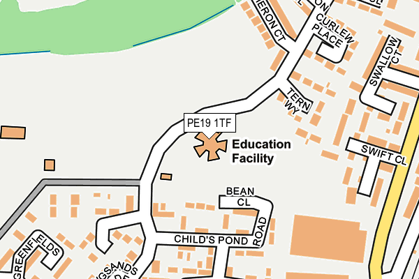
PE19 1TF is located in the St Neots Priory Park & Little Paxton electoral ward, within the local authority district of Huntingdonshire and the English Parliamentary constituency of Huntingdon. The Sub Integrated Care Board (ICB) Location is NHS Cambridgeshire and Peterborough ICB - 06H and the police force is Cambridgeshire. This postcode has been in use since January 1980.


GetTheData
Source: OS OpenMap – Local (Ordnance Survey)
Source: OS VectorMap District (Ordnance Survey)
Licence: Open Government Licence (requires attribution)
| Easting | 519406 |
| Northing | 260746 |
| Latitude | 52.231986 |
| Longitude | -0.252999 |
GetTheData
Source: Open Postcode Geo
Licence: Open Government Licence
| Country | England |
| Postcode District | PE19 |
➜ See where PE19 is on a map ➜ Where is St Neots? | |
GetTheData
Source: Land Registry Price Paid Data
Licence: Open Government Licence
Elevation or altitude of PE19 1TF as distance above sea level:
| Metres | Feet | |
|---|---|---|
| Elevation | 20m | 66ft |
Elevation is measured from the approximate centre of the postcode, to the nearest point on an OS contour line from OS Terrain 50, which has contour spacing of ten vertical metres.
➜ How high above sea level am I? Find the elevation of your current position using your device's GPS.
GetTheData
Source: Open Postcode Elevation
Licence: Open Government Licence
| Ward | St Neots Priory Park & Little Paxton |
| Constituency | Huntingdon |
GetTheData
Source: ONS Postcode Database
Licence: Open Government Licence
| Greenfields (Longsands Road) | St Neots | 36m |
| Princes Drive (Longsands Road) | St Neots | 176m |
| Princes Drive (Longsands Road) | St Neots | 204m |
| Heron Court (Longsands Road) | St Neots | 244m |
| Heron Court (Longsands Road) | St Neots | 284m |
| St Neots Station | 0.4km |
GetTheData
Source: NaPTAN
Licence: Open Government Licence
GetTheData
Source: ONS Postcode Database
Licence: Open Government Licence


➜ Get more ratings from the Food Standards Agency
GetTheData
Source: Food Standards Agency
Licence: FSA terms & conditions
| Last Collection | |||
|---|---|---|---|
| Location | Mon-Fri | Sat | Distance |
| Longsands Parade | 17:30 | 12:00 | 165m |
| Station Road | 17:30 | 12:00 | 378m |
| Cromwell Gardens | 17:30 | 12:00 | 449m |
GetTheData
Source: Dracos
Licence: Creative Commons Attribution-ShareAlike
The below table lists the International Territorial Level (ITL) codes (formerly Nomenclature of Territorial Units for Statistics (NUTS) codes) and Local Administrative Units (LAU) codes for PE19 1TF:
| ITL 1 Code | Name |
|---|---|
| TLH | East |
| ITL 2 Code | Name |
| TLH1 | East Anglia |
| ITL 3 Code | Name |
| TLH12 | Cambridgeshire CC |
| LAU 1 Code | Name |
| E07000011 | Huntingdonshire |
GetTheData
Source: ONS Postcode Directory
Licence: Open Government Licence
The below table lists the Census Output Area (OA), Lower Layer Super Output Area (LSOA), and Middle Layer Super Output Area (MSOA) for PE19 1TF:
| Code | Name | |
|---|---|---|
| OA | E00091756 | |
| LSOA | E01018190 | Huntingdonshire 019D |
| MSOA | E02003771 | Huntingdonshire 019 |
GetTheData
Source: ONS Postcode Directory
Licence: Open Government Licence
| PE19 1TE | Longsands Road | 48m |
| PE19 1TT | Childs Pond Road | 77m |
| PE19 1TD | Greenfields | 95m |
| PE19 1TB | Longsands Road | 109m |
| PE19 1TX | Bean Close | 114m |
| PE19 1TU | Childs Pond Road | 140m |
| PE19 1TA | Longsands Road | 153m |
| PE19 1SU | Longsands Parade | 172m |
| PE19 1SL | Greenfields | 179m |
| PE19 1SN | Princes Drive | 191m |
GetTheData
Source: Open Postcode Geo; Land Registry Price Paid Data
Licence: Open Government Licence