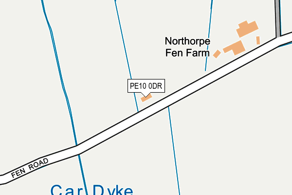
PE10 0DR is located in the Dole Wood electoral ward, within the local authority district of South Kesteven and the English Parliamentary constituency of Grantham and Stamford. The Sub Integrated Care Board (ICB) Location is NHS Lincolnshire ICB - 71E and the police force is Lincolnshire. This postcode has been in use since January 1980.


GetTheData
Source: OS OpenMap – Local (Ordnance Survey)
Source: OS VectorMap District (Ordnance Survey)
Licence: Open Government Licence (requires attribution)
| Easting | 510669 |
| Northing | 317800 |
| Latitude | 52.746521 |
| Longitude | -0.361944 |
GetTheData
Source: Open Postcode Geo
Licence: Open Government Licence
| Country | England |
| Postcode District | PE10 |
➜ See where PE10 is on a map | |
GetTheData
Source: Land Registry Price Paid Data
Licence: Open Government Licence
Elevation or altitude of PE10 0DR as distance above sea level:
| Metres | Feet | |
|---|---|---|
| Elevation | 10m | 33ft |
Elevation is measured from the approximate centre of the postcode, to the nearest point on an OS contour line from OS Terrain 50, which has contour spacing of ten vertical metres.
➜ How high above sea level am I? Find the elevation of your current position using your device's GPS.
GetTheData
Source: Open Postcode Elevation
Licence: Open Government Licence
| Ward | Dole Wood |
| Constituency | Grantham And Stamford |
GetTheData
Source: ONS Postcode Database
Licence: Open Government Licence
| Fen Lane (Bourne Road) | Northorpe | 489m |
| Demand Responsive Area | Northorpe | 502m |
| Fen Lane (Bourne Road) | Northorpe | 516m |
| The Horseshoe Ph (Main Road) | Thurlby | 1,018m |
| Demand Responsive Area | Thurlby | 1,036m |
GetTheData
Source: NaPTAN
Licence: Open Government Licence
| Percentage of properties with Next Generation Access | 100.0% |
| Percentage of properties with Superfast Broadband | 100.0% |
| Percentage of properties with Ultrafast Broadband | 0.0% |
| Percentage of properties with Full Fibre Broadband | 0.0% |
Superfast Broadband is between 30Mbps and 300Mbps
Ultrafast Broadband is > 300Mbps
| Percentage of properties unable to receive 2Mbps | 0.0% |
| Percentage of properties unable to receive 5Mbps | 0.0% |
| Percentage of properties unable to receive 10Mbps | 0.0% |
| Percentage of properties unable to receive 30Mbps | 0.0% |
GetTheData
Source: Ofcom
Licence: Ofcom Terms of Use (requires attribution)
GetTheData
Source: ONS Postcode Database
Licence: Open Government Licence


➜ Get more ratings from the Food Standards Agency
GetTheData
Source: Food Standards Agency
Licence: FSA terms & conditions
| Last Collection | |||
|---|---|---|---|
| Location | Mon-Fri | Sat | Distance |
| Thurlby Cross Roads | 16:05 | 07:00 | 1,031m |
| Tillia Way | 16:00 | 12:45 | 1,216m |
| Thurlby Post Office | 16:00 | 12:45 | 1,471m |
GetTheData
Source: Dracos
Licence: Creative Commons Attribution-ShareAlike
The below table lists the International Territorial Level (ITL) codes (formerly Nomenclature of Territorial Units for Statistics (NUTS) codes) and Local Administrative Units (LAU) codes for PE10 0DR:
| ITL 1 Code | Name |
|---|---|
| TLF | East Midlands (England) |
| ITL 2 Code | Name |
| TLF3 | Lincolnshire |
| ITL 3 Code | Name |
| TLF30 | Lincolnshire CC |
| LAU 1 Code | Name |
| E07000141 | South Kesteven |
GetTheData
Source: ONS Postcode Directory
Licence: Open Government Licence
The below table lists the Census Output Area (OA), Lower Layer Super Output Area (LSOA), and Middle Layer Super Output Area (MSOA) for PE10 0DR:
| Code | Name | |
|---|---|---|
| OA | E00133901 | |
| LSOA | E01026360 | South Kesteven 012B |
| MSOA | E02005487 | South Kesteven 012 |
GetTheData
Source: ONS Postcode Directory
Licence: Open Government Licence
| PE10 0DZ | Bourne Road | 514m |
| PE10 0LQ | Bourne Road | 536m |
| PE10 0XU | Pulford Close | 546m |
| PE10 0HT | Woodside East | 629m |
| PE10 0HZ | Northorpe | 638m |
| PE10 0HR | Cappitts Drive | 730m |
| PE10 0HL | Elsea Drive | 767m |
| PE10 0HW | Woodside Close | 807m |
| PE10 0HN | Elizabeth Way | 846m |
| PE10 0EQ | St Firmins Way | 910m |
GetTheData
Source: Open Postcode Geo; Land Registry Price Paid Data
Licence: Open Government Licence