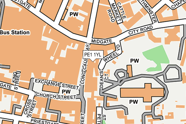
PE1 1YL is located in the Central electoral ward, within the unitary authority of Peterborough and the English Parliamentary constituency of Peterborough. The Sub Integrated Care Board (ICB) Location is NHS Cambridgeshire and Peterborough ICB - 06H and the police force is Cambridgeshire. This postcode has been in use since March 2013.


GetTheData
Source: OS OpenMap – Local (Ordnance Survey)
Source: OS VectorMap District (Ordnance Survey)
Licence: Open Government Licence (requires attribution)
| Easting | 519252 |
| Northing | 298743 |
| Latitude | 52.573461 |
| Longitude | -0.241738 |
GetTheData
Source: Open Postcode Geo
Licence: Open Government Licence
| Country | England |
| Postcode District | PE1 |
➜ See where PE1 is on a map ➜ Where is Peterborough? | |
GetTheData
Source: Land Registry Price Paid Data
Licence: Open Government Licence
Elevation or altitude of PE1 1YL as distance above sea level:
| Metres | Feet | |
|---|---|---|
| Elevation | 10m | 33ft |
Elevation is measured from the approximate centre of the postcode, to the nearest point on an OS contour line from OS Terrain 50, which has contour spacing of ten vertical metres.
➜ How high above sea level am I? Find the elevation of your current position using your device's GPS.
GetTheData
Source: Open Postcode Elevation
Licence: Open Government Licence
| Ward | Central |
| Constituency | Peterborough |
GetTheData
Source: ONS Postcode Database
Licence: Open Government Licence
| Hereward Cross (Midgate) | Peterborough | 66m |
| Hereward Cross (Midgate) | Peterborough | 85m |
| Tesco (Broadway) | Peterborough | 141m |
| Tesco (Broadway) | Peterborough | 150m |
| Tesco (Broadway) | Peterborough | 176m |
| Peterborough (Nene Valley Railway) | Woodston | 768m |
| Peterborough Station | 0.6km |
GetTheData
Source: NaPTAN
Licence: Open Government Licence
| Percentage of properties with Next Generation Access | 0.0% |
| Percentage of properties with Superfast Broadband | 0.0% |
| Percentage of properties with Ultrafast Broadband | 0.0% |
| Percentage of properties with Full Fibre Broadband | 0.0% |
Superfast Broadband is between 30Mbps and 300Mbps
Ultrafast Broadband is > 300Mbps
| Percentage of properties unable to receive 2Mbps | 0.0% |
| Percentage of properties unable to receive 5Mbps | 0.0% |
| Percentage of properties unable to receive 10Mbps | 0.0% |
| Percentage of properties unable to receive 30Mbps | 100.0% |
GetTheData
Source: Ofcom
Licence: Ofcom Terms of Use (requires attribution)
GetTheData
Source: ONS Postcode Database
Licence: Open Government Licence


➜ Get more ratings from the Food Standards Agency
GetTheData
Source: Food Standards Agency
Licence: FSA terms & conditions
| Last Collection | |||
|---|---|---|---|
| Location | Mon-Fri | Sat | Distance |
| Cathedral Square | 18:30 | 17:45 | 157m |
| Westgate | 18:30 | 11:45 | 251m |
| New Road | 18:45 | 12:00 | 296m |
GetTheData
Source: Dracos
Licence: Creative Commons Attribution-ShareAlike
The below table lists the International Territorial Level (ITL) codes (formerly Nomenclature of Territorial Units for Statistics (NUTS) codes) and Local Administrative Units (LAU) codes for PE1 1YL:
| ITL 1 Code | Name |
|---|---|
| TLH | East |
| ITL 2 Code | Name |
| TLH1 | East Anglia |
| ITL 3 Code | Name |
| TLH11 | Peterborough |
| LAU 1 Code | Name |
| E06000031 | Peterborough |
GetTheData
Source: ONS Postcode Directory
Licence: Open Government Licence
The below table lists the Census Output Area (OA), Lower Layer Super Output Area (LSOA), and Middle Layer Super Output Area (MSOA) for PE1 1YL:
| Code | Name | |
|---|---|---|
| OA | E00078897 | |
| LSOA | E01015599 | Peterborough 014A |
| MSOA | E02003250 | Peterborough 014 |
GetTheData
Source: ONS Postcode Directory
Licence: Open Government Licence
| PE1 1XS | Minster Precincts | 42m |
| PE1 1YJ | Long Causeway | 46m |
| PE1 1TN | Midgate | 58m |
| PE1 1PX | Westgate | 82m |
| PE1 1XZ | Minster Precincts | 119m |
| PE1 1XH | Cathedral Square | 144m |
| PE1 1YR | Cumbergate | 152m |
| PE1 1PZ | Westgate | 166m |
| PE1 2GA | Park Road | 181m |
| PE1 1RS | Broadway | 193m |
GetTheData
Source: Open Postcode Geo; Land Registry Price Paid Data
Licence: Open Government Licence